Upstate Tiger
-
Posts
984 -
Joined
-
Last visited
Content Type
Profiles
Blogs
Forums
American Weather
Media Demo
Store
Gallery
Everything posted by Upstate Tiger
-
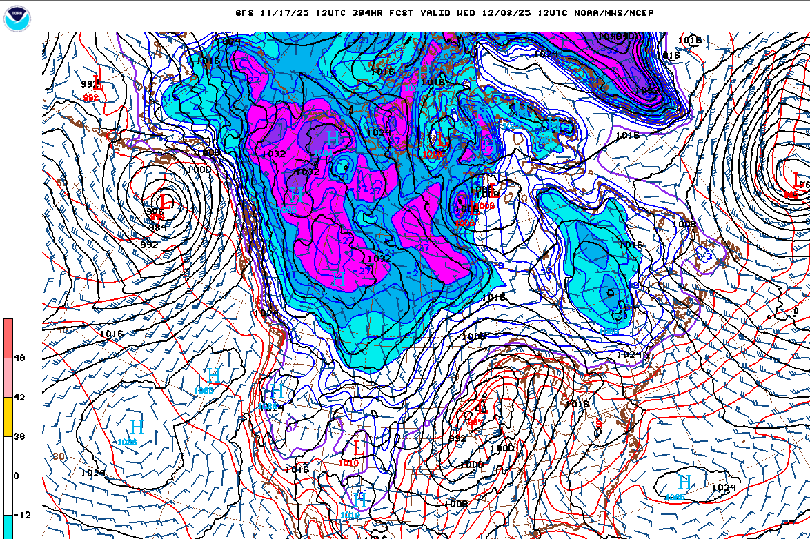
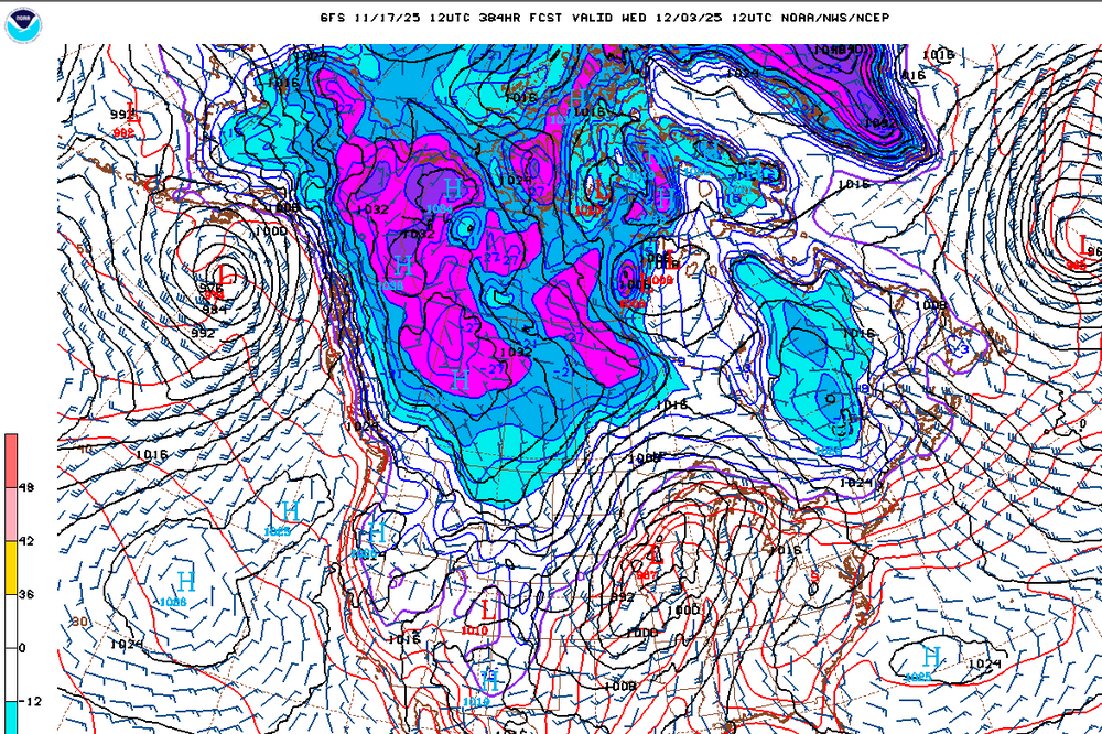
Lots of cold air finally filling up Western Canada. Does not always mean it comes into the SE as we've seen the last few years but for any chance at BN, Canada has to be super cold. Hopefully that ridge can get tamped down and the trough axis moves east with time.
-
Felt like an Edmund Fitzgerald day driving home. Grey with a howling NE wind. Obviously nothing like the 978mb bomb that sank the Fitz with 86 mph winds and 30 foot seas. Played Gordon Lighfoot in honor of the 29 souls lost 50 years ago today.
-
Grey and blustery in West Lincoln. Temp 37 with wind chill of 20 and Virga storm on top of us for last hour.
-
After the warmup both GFS and Euro remarkably both show a strong cold front traversing the country in a couple of weeks.
-
Hopefully this is a track and pattern that lasts through the winter
-
I can work with that!
-
Starting to see Canada fill up with colder air after mid-month and even some lake effect on the ops models.
-
Next weekend looks nice with highs in the 60s. Looking forward to it.
-
Finally seeing some colder air making its way into the US and eventually SE by the first and second weeks of October. https://www.pivotalweather.com/model.php?p=sfct_anom-imp
-
Kids will need a light jacket in the mornings midweek.
-
Starting to see snowfall pop up on the long range GFS along the northern border states. Also seeing a gulf hurricane showing up pretty consistenly at two weeks. Would love to see a nice hurricane free fall this year!
-
Headed to the coast next weekend. It sure seems Erin nudges closer to the coast with each GFS and Euro run. Haven't seen any forecasters predicting landfall but some have said we could experience some outter bands.
-
Picked up 2.3" last evening of welcomed rain. Lightening was very intenses but very little wind and no hail. Power flickered several times but never went completely off...
-
Not a forecast endorsement but interesting reading for a hot afternoon. Provides education on the complicated relationship of winter teleconnections. https://www.severe-weather.eu/long-range-2/early-forecast-data-weak-polar-vortex-united-states-canada-winter-2025-2026-fa/
-
As we wait for our impending heat wave to develop over the weekend, the latest ENSO forecast is out. Looks to stay neutral into the fall. Overall forecast still showing neutral to last into January (48%) but weak Nina has increased (41%) for late fall early next year. https://www.cpc.ncep.noaa.gov/products/analysis_monitoring/lanina/enso_evolution-status-fcsts-web.pdf
-
There are things in life to be miserable over. Weather isn’t one of those. It always changing whether we want it to or not.
-
Had to mow my grass for the 2nd time in a week. Never want to complain about rain though and it has held the temps down. Mosquitos are at plague level. Looks like we may hit 90 next weekend. Good news is after next Saturday it gets darker earlier everyday until Christmas.
-
Little over half inch of welcomed rainfall today. Hopefully some more next couple of days.
-
37 this morning when I left for work. Wasn't prepared for it to be that cold. Looking forward to tomorrow when it will be near 80. It also be my first time on the golf course since rotator cuff surgery in January.
-
Just had hail with band that went through Lincolnton.
-
La Nina died a quiet death and we are now in an ENSO neutral state that looks to last into the fall. After that, forecasts favor a continuation of neautral or weak Nina. El Nino conditions are not favored at this time. I am all in on neutral for summer, fall, and winter. https://iri.columbia.edu/our-expertise/climate/forecasts/enso/current/
-
While we are near 90 on Saturday, west Texas will experiencing a major snowstorm. Imagine jumping on a plane in Charlotte in sweltering heat and landing in Amarillo and a snowstorm?
-
That’s why I started wearing Depends.
-
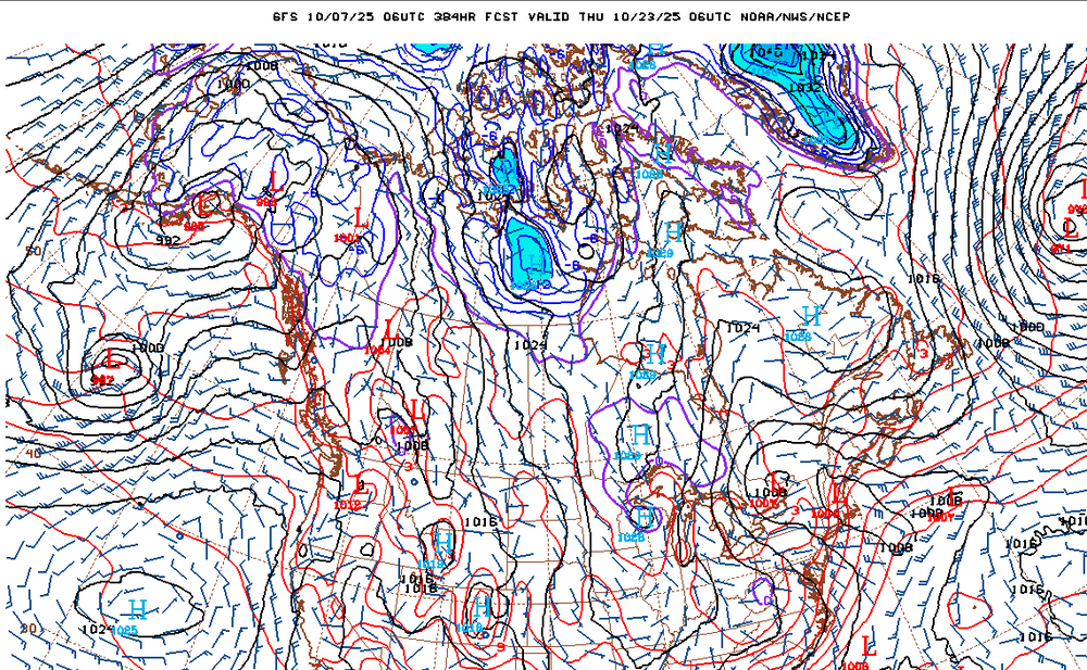
Yep. Crazy looking at extended models and seeing how much snow is forecast across the US over the next 2 weeks. Indication of how cold will be in the lower 48. The pool will be frigid when it is opened in May.
-
Still remember that day. I was a freshman in college. Rained in the morning and then sun came out. When I came out of class after lunch, I remember walking across campus thinking “why is so hot and why am I sweating so much?” Had no idea what was on the way. Guys in the room next door to me in the dorm were from Marlboro County. Left as soon as they got word and went home to help. Had this outbreak happened in a more populated area, hundreds would have died. Article The worst tornado outbreak in Carolina History unfolded 41 years ago today. 24 tornadoes, 7 of which were EF-4, raced across the Carolinas at 65 mph. At the end of the 7 hour outbreak, 57 had been killed and over 1200 injured. Marlboro County took a devastating hit with 2 EF-4 tornadoes striking in less than an hour. One of those grew to 2.5 miles wide and was on the ground for 45 miles. The picture of the beam impaled in the ground below remains in Bennettsville as a monument to the outbreak. Jeffrey Bryant