Upstate Tiger
-
Posts
984 -
Joined
-
Last visited
Content Type
Profiles
Blogs
Forums
American Weather
Media Demo
Store
Gallery
Everything posted by Upstate Tiger
-

January 25/26 Jimbo Back Surgery Storm
Upstate Tiger replied to Jimbo!'s topic in Southeastern States
30 straight hours of precip for NC. -
January 25/26 Jimbo Back Surgery Storm
Upstate Tiger replied to Jimbo!'s topic in Southeastern States
Quickly goes over to ice but closer to GFS -
January 25/26 Jimbo Back Surgery Storm
Upstate Tiger replied to Jimbo!'s topic in Southeastern States
Euro with a little front end snow at 60 for NC -
January 25/26 Jimbo Back Surgery Storm
Upstate Tiger replied to Jimbo!'s topic in Southeastern States
Euro and GFS surface reflections look very similar at 54 with timing and precip types. -
I knew this thing would correct back to the SE…oh crap. That’s next weekend.
-
January 25/26 Jimbo Back Surgery Storm
Upstate Tiger replied to Jimbo!'s topic in Southeastern States
After this cluster I am not looking at any models for next weekend until next Thursday...BTW, Do you happen to have a snowfall map of next weekend? -
January 25/26 Jimbo Back Surgery Storm
Upstate Tiger replied to Jimbo!'s topic in Southeastern States
Given the alternatives, I would prefer what the GFS is showing for NC. More sleet, less freezing rain. -
January 25/26 Jimbo Back Surgery Storm
Upstate Tiger replied to Jimbo!'s topic in Southeastern States
He's probably taking his talking points from the mets at GSP. I was on a regional call this morning with EM, healthcare, utilities etc and the forecasters at GSP were painting a pretty grim picture for this weekend using words like "memorable storm" and "devastating impacts." They seemed pretty concerned. Maybe after Helene they just want everyone to take the threat serious. We're looking at this as amateurs (except the red tags) but those guys GSP are pros and have to make high stakes forecasts. -
January 25/26 Jimbo Back Surgery Storm
Upstate Tiger replied to Jimbo!'s topic in Southeastern States
NAM with precip on NC's doorstep at 15Z Saturday. That's faster onset. -
January 25/26 Jimbo Back Surgery Storm
Upstate Tiger replied to Jimbo!'s topic in Southeastern States
Just went out a couple of hours ago to get one of my LP tanks filled/exchanged, grab a few groceries, and get some gas. Mission was unsuccessful. If you don’t have it by now, you ain’t gettin it. -
January 25/26 Jimbo Back Surgery Storm
Upstate Tiger replied to Jimbo!'s topic in Southeastern States
Best GFS run in 24 hours. For NC snow on the front, sleet, and then snow on the backend. -
January 25/26 Jimbo Back Surgery Storm
Upstate Tiger replied to Jimbo!'s topic in Southeastern States
Yeah really hoping to see precip work it's away into the Carolinas earlier than what NAM is showing but there are some positives and we are still at the end of the NAM's range and reliability. -
January 25/26 Jimbo Back Surgery Storm
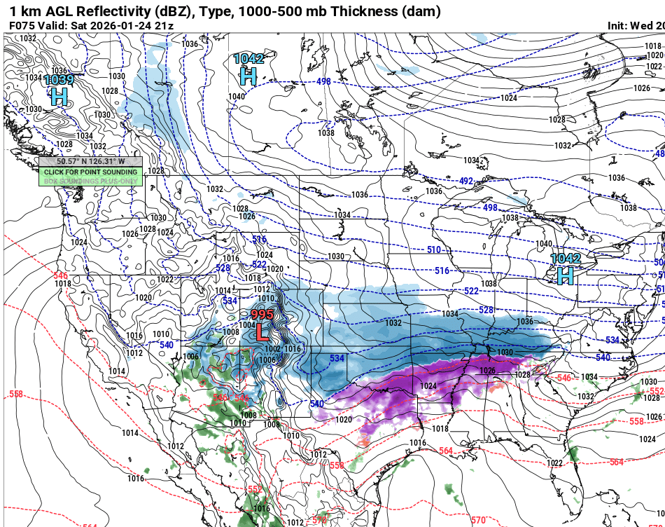
Upstate Tiger replied to Jimbo!'s topic in Southeastern States
NAM surface at 75
-
January 25/26 Jimbo Back Surgery Storm
Upstate Tiger replied to Jimbo!'s topic in Southeastern States
Yeah I don’t know what we were thinking. We’re not in Pensacola where they get 8”-10” of all snow. -
January 25/26 Jimbo Back Surgery Storm
Upstate Tiger replied to Jimbo!'s topic in Southeastern States
Go to Best Buy and buy a StarLink! I went and got one yesterday. That way we can still whine. -
January 25/26 Jimbo Back Surgery Storm
Upstate Tiger replied to Jimbo!'s topic in Southeastern States
For much of NC, the GFS would provide some epic sledding. A couple inches of snow, couple inches of sleet, and some freezing rain on top and it ain't going anywhere. -
January 25/26 Jimbo Back Surgery Storm
Upstate Tiger replied to Jimbo!'s topic in Southeastern States
Crazy evlolution of the system on the GFS but definetly a more favorable outcome for NC and SC. -
January 25/26 Jimbo Back Surgery Storm
Upstate Tiger replied to Jimbo!'s topic in Southeastern States
Models handled the thermals on the 2003 PD2 terribly. We were told for 5 days to prepare for an apocalyptic ice storm but had a sleet storm instead. -
January 25/26 Jimbo Back Surgery Storm
Upstate Tiger replied to Jimbo!'s topic in Southeastern States
Overnight trends not good. We’ve gone from January 88 to Presidents Day 2003. I do think the 06z GFS has a better handle on the thermals than the NAM or Euro at 84 hours. Still have a 1051 High in NY. The CADs not being represented well IMO. -
January 25/26 Jimbo Back Surgery Storm
Upstate Tiger replied to Jimbo!'s topic in Southeastern States
Whatever verifies, I have never seen back to back model runs as epic for NC as the GFS runs today. 3 day winter storm. Feb 14 was close but this is nuts. -
January 25/26 Jimbo Back Surgery Storm
Upstate Tiger replied to Jimbo!'s topic in Southeastern States
KGSP AFD. https://forecast.weather.gov/product.php?site=NWS&issuedby=GSP&product=AFD&format=ci&version=1&glossary=1&highlight=off Boys and girls...remember these next several days. You will be talking about them and posting maps long after I have gone on... -
January 25/26 Jimbo Back Surgery Storm
Upstate Tiger replied to Jimbo!'s topic in Southeastern States
Not good for SC but a lot of that would likely be sleet. -
January 25/26 Jimbo Back Surgery Storm
Upstate Tiger replied to Jimbo!'s topic in Southeastern States
Lot of similarities to the January 88 storm with this setup. https://www.weather.gov/media/gsp/localdat/TechAttachments/ta2001-02.pdf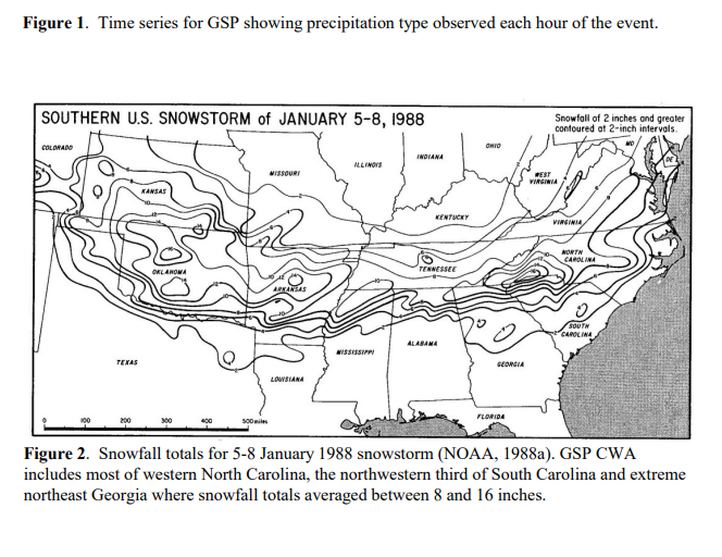
-
Models hinting at another winter storm possibility the following weekend, 30/31st. Interesting period upcoming in the SE. Will have the LP tank refilled this week and test the generator for sure.
-