

Upstate Tiger
-
Posts
984 -
Joined
-
Last visited
Content Type
Profiles
Blogs
Forums
American Weather
Media Demo
Store
Gallery
Everything posted by Upstate Tiger
-
33 in Cherryville in the piedmont of NC. No frost as winds were too brisk.
-

Mid to Long Range Discussion ~ 2023
Upstate Tiger replied to buckeyefan1's topic in Southeastern States
Like seeing the CPC 8-14 day hazard map with the blue here https://www.cpc.ncep.noaa.gov/products/predictions/threats/threats.php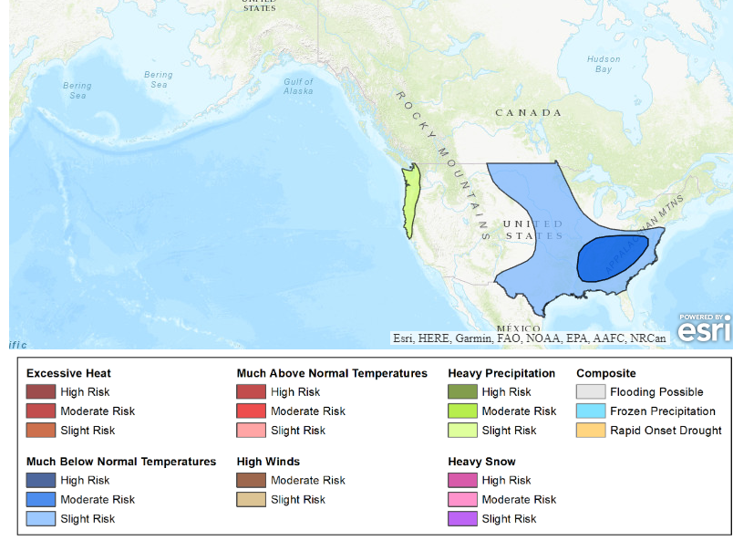
-
Mid to Long Range Discussion ~ 2023
Upstate Tiger replied to buckeyefan1's topic in Southeastern States
Hmmm. Another cold shot in two weeks after next weeks cold shot?
-
Finally saw our first patches of frost here in Cherryville this morning. Wasn't widespread but rooftops and yards in the low lying spots were white.
-
Mid to Long Range Discussion ~ 2023
Upstate Tiger replied to buckeyefan1's topic in Southeastern States
I was a senior in college in 87/88 and October was really cold in the upstate. I think GW posted a correlation between BN October’s in EN and wintery precip. I remember many days going to lunch with temps in the low to mid 50s. We had snow flurries on Halloween and big snow in January. 86/87 was a EN year too but don’t remember October being cold. Of course JFM were really good that year. -
Mid to Long Range Discussion ~ 2023
Upstate Tiger replied to buckeyefan1's topic in Southeastern States
Finally starting to see some colder air filter into central and western Canada at the end of the month and beginning of October. -
Mid to Long Range Discussion ~ 2023
Upstate Tiger replied to buckeyefan1's topic in Southeastern States
It’s never right at this range with a winter storm but watch it be right with a cat 4 hurricane. -
Mid to Long Range Discussion ~ 2023
Upstate Tiger replied to buckeyefan1's topic in Southeastern States
Of course it’s a historic anomaly. I’ll be at Myrtle Beach Saturday - Wednesday. -
Good analysis on Tennessee upcoming winter forum for those interested.
-
In Myrtle Beach on 6th floor of hotel. Storms right on our doorstep. Winds are making a creepy howling sound. Told the wife I can’t imagine what the wind would sound like in here in a hurricane.
-
Mid to Long Range Discussion ~ 2023
Upstate Tiger replied to buckeyefan1's topic in Southeastern States
Hope he's right Cary. BTW, just saw the other thread on 23/24 winter predictions... -
Mid to Long Range Discussion ~ 2023
Upstate Tiger replied to buckeyefan1's topic in Southeastern States
While we deal with this ongoing hot pattern...latest ENSO predictions increase chance for moderate to strong El Nino. 97/98 and 15/16 are analogs. Neither were stellar years in the SE FWIW but it only takes one! The most recent IRI plume indicates El Niño will persist through the Northern Hemisphere winter 2023-24 [Fig. 6]. Forecasters favor continued growth of El Niño through the fall, peaking this winter with moderate-to-strong intensity (81% chance of November-January Niño-3.4 ≥ 1.0°C). An event that becomes "historically strong" (seasonally averaged Niño-3.4 ≥ 2.0°C), rivaling the winters of 1997-98 or 2015-16, has an approximately 1 in 5 chance. In summary, there is a greater than 90% chance that El Niño will continue through the Northern Hemisphere winter [Fig. 7]. https://www.cpc.ncep.noaa.gov/products/analysis_monitoring/enso_advisory/ensodisc.shtml -
2023 Mountains Spring/Summer Thread
Upstate Tiger replied to Tyler Penland's topic in Southeastern States
Yeah, we were under it. About 3.5 hours moderate to heavy rain. Lost power for 2.5 hours. Not complaining. We were very dry. -
Mid to Long Range Discussion ~ 2023
Upstate Tiger replied to buckeyefan1's topic in Southeastern States
Figures. Was supposed to play in a golf tournament tomorrow lol. Can't complain too much. We finally had a nice weekend. -
Mid to Long Range Discussion ~ 2023
Upstate Tiger replied to buckeyefan1's topic in Southeastern States
Yep. I love the 76-80 weak nino! 4 straight epic winters from my youth! I believe that was a also a predominantly negative NAO. -
Mid to Long Range Discussion ~ 2023
Upstate Tiger replied to buckeyefan1's topic in Southeastern States
Looking ahead to fall and winter. Odds are increasing of a moderate to strong El Nino in the late fall and winter. Climatologically, not great for SE snow but has to be better than 3 years of Nina. I have posted the strong to moderate El Nino years below. There are some winners in the there for major storms... https://www.cpc.ncep.noaa.gov/products/analysis_monitoring/lanina/enso_evolution-status-fcsts-web.pdf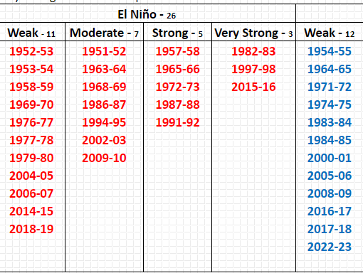
-
Mid to Long Range Discussion ~ 2023
Upstate Tiger replied to buckeyefan1's topic in Southeastern States
From KGSP AM AFD...can we ever get a flippin weekend with no rain? "Have higher chance PoPs the rest of the long term as guidance is generally trending wetter this weekend into early next week." -
Mid to Long Range Discussion ~ 2023
Upstate Tiger replied to buckeyefan1's topic in Southeastern States
BTW. The average global temp was down 1 degree. -
Mid to Long Range Discussion ~ 2023
Upstate Tiger replied to buckeyefan1's topic in Southeastern States
Most failed. Led to widespread food shortages in America and Europe. -
Mid to Long Range Discussion ~ 2023
Upstate Tiger replied to buckeyefan1's topic in Southeastern States
Reading some stuff this morning about 1816, the year without summer. Our current pattern is in no way similar to that global event brought on largely by the eruption of Mt Tambora. Nevertheless, fascinating reading. The New England states had frost every month that year and widespread snow in June. Philadelphia had frost on the 4th of July and Augusta Ga had a low of 43. Several other crazy anomalies that summer that are worth checking out. -
52 this morning in Cherryville. Unreal. Not complaining though!
-
Mid to Long Range Discussion ~ 2023
Upstate Tiger replied to buckeyefan1's topic in Southeastern States
Highs Saturday and Sunday may not get out of the low 50's. That would be 30 degrees below average and easily set records for low maximums. The pool is opening this weekend at the country club. Think we'll hold off a week. Probably won't be difficult to get chairs though... -
53 this morning in Cherryville. Very refreshing.
-
Mid to Long Range Discussion ~ 2023
Upstate Tiger replied to buckeyefan1's topic in Southeastern States
Would have been really interesting to have seen this weekend's setup in January or February. https://forecast.weather.gov/product.php?site=NWS&issuedby=GSP&product=AFD&format=ci&version=1&glossary=1&highlight=off -
39 this morning in Cherryville. Has felt like fall last several days. Hard to believe July 4 is 8 weeks away.


