

Upstate Tiger
-
Posts
983 -
Joined
-
Last visited
Content Type
Profiles
Blogs
Forums
American Weather
Media Demo
Store
Gallery
Everything posted by Upstate Tiger
-

February 11-12 ULL Winter Storm
Upstate Tiger replied to Upstate Tiger's topic in Southeastern States
This one stinks because it fizzled so dramatically. Hopefully with the end of Nina we can really have some storms to track next year. Who knows, this year may yield a surprise. -
February 11-12 ULL Winter Storm
Upstate Tiger replied to Upstate Tiger's topic in Southeastern States
lilj, brought the wife to downtown Greenville tonight for Valentines weekend. First time here in 6 1/2 years since we moved to NC. Didn’t recognize the area. Amazing how much it’s grown. Still had an awesome time eating at Sobys and going to jazz club by the river. -
February 11-12 ULL Winter Storm
Upstate Tiger replied to Upstate Tiger's topic in Southeastern States
Frustrating is an understatement. Hang in there though. This issue if far from settled. I am reserving all judgement until tomorrow's afternoon suite comes out. -
February 11-12 ULL Winter Storm
Upstate Tiger replied to Upstate Tiger's topic in Southeastern States
By Saturday we should be in the jackpot zone -
February 11-12 ULL Winter Storm
Upstate Tiger replied to Upstate Tiger's topic in Southeastern States
NAM was definitely an improvement for the foothills of the Carolinas. Now just just a little bit more to get us in the game from Shelby, Lincolnton, Mooresville line north and west. -
February 11-12 ULL Winter Storm
Upstate Tiger replied to Upstate Tiger's topic in Southeastern States
When it comes to SE snow it is every man (lady) for himself! -
February 11-12 ULL Winter Storm
Upstate Tiger replied to Upstate Tiger's topic in Southeastern States
Has anyone seen the KGSP AFD for this afternoon? Still showing the morning AFD. -
February 11-12 ULL Winter Storm
Upstate Tiger replied to Upstate Tiger's topic in Southeastern States
The NAM needs to continue to shift east about 100 miles. -
February 11-12 ULL Winter Storm
Upstate Tiger replied to Upstate Tiger's topic in Southeastern States
At 72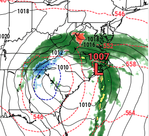
-
February 11-12 ULL Winter Storm
Upstate Tiger replied to Upstate Tiger's topic in Southeastern States
At 66.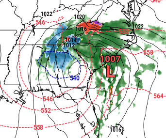
-
February 11-12 ULL Winter Storm
Upstate Tiger replied to Upstate Tiger's topic in Southeastern States
At 60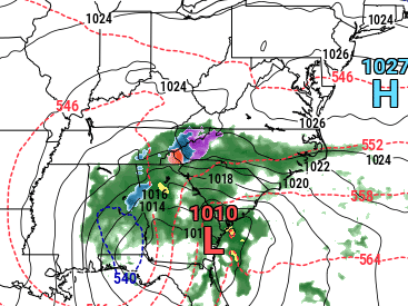
-
February 11-12 ULL Winter Storm
Upstate Tiger replied to Upstate Tiger's topic in Southeastern States
Not sure which one you are looking for but this is through 54...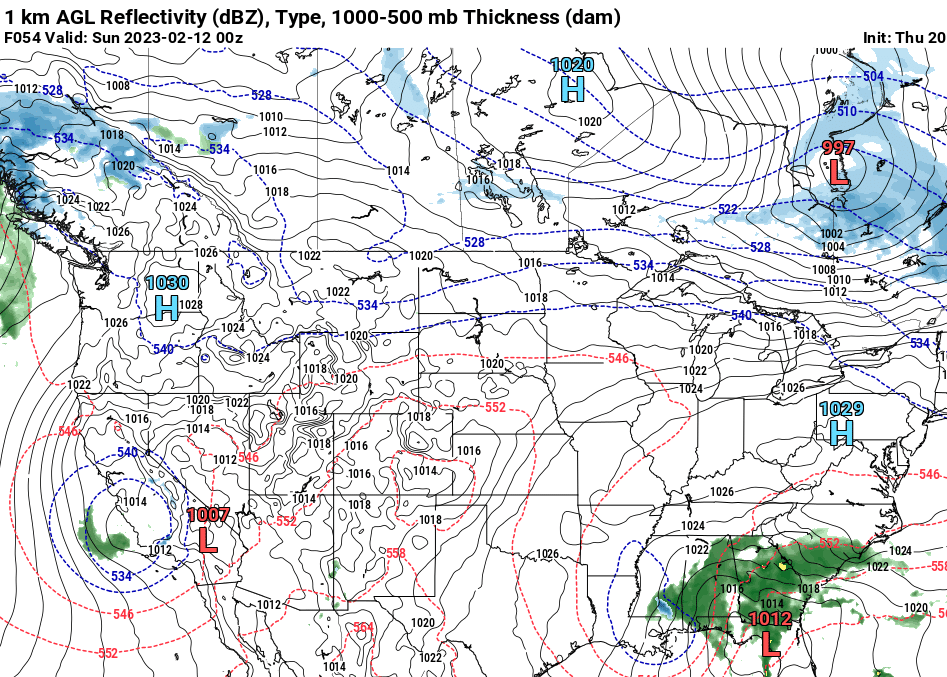
-
February 11-12 ULL Winter Storm
Upstate Tiger replied to Upstate Tiger's topic in Southeastern States
True. I was in the upstate. 2011, 2014, 2015, and 2016 had good events. 2019 was a good year here in the western NC Piedmont. The 2000s didn’t produce much in my area outside Presidents’ Day storm. Still no pattern that rivals the 70s or 80s or even 1996. 2011 was probably the closest. -
February 11-12 ULL Winter Storm
Upstate Tiger replied to Upstate Tiger's topic in Southeastern States
I know many of us in the south get frustrated when we do not see snow when it is forecast, especially since it has become so rare in recent years (or decades). I look at like this. I am probably the biggest winnie on here but if there is no snow this weekend, so be it. I'll be disappointed but it was fun tracking the last couple of days. It's a welcome diversion from all the serious things we deal with in life. I will just move on to looking for the next threat. If nothing happens this year, I will start reading ENSO predictions in June and start tracking again next fall. I just feel for the younger posters under 40 who did not get to experience some of the great winters of the 70's and 80's around here. But even then, a good year was 2-3 events. The climate has changed. In next 20 years or so when I am gone, you younger posters will probably be experiencing another shift. That's what the weather does. That's what makes it so fun to follow. -
February 11-12 ULL Winter Storm
Upstate Tiger replied to Upstate Tiger's topic in Southeastern States
Yeah. I gotta say there’s a lot of handwringing here in western NC and SC outside the mountains over what happens but I would be most nervous if I was in eastern Tenn. -
Mid to Long Range Discussion ~ 2023
Upstate Tiger replied to buckeyefan1's topic in Southeastern States
Nice
-
February 11-12 ULL Winter Storm
Upstate Tiger replied to Upstate Tiger's topic in Southeastern States
Just got a peak at the Euro. Hospital occasionally expects me to do some work. They're funny that way. I actually like that track and it's more in line with what Snowgoose was saying. I think anyone between I 75 and I 85 is still in play. -
February 11-12 ULL Winter Storm
Upstate Tiger replied to Upstate Tiger's topic in Southeastern States
Has it been sampled??. Not paying attention to any forecasts until the Chinese ballon samples it. -
February 11-12 ULL Winter Storm
Upstate Tiger replied to Upstate Tiger's topic in Southeastern States
Yep, don't like that track. Hope Matt chimes in again... -
February 11-12 ULL Winter Storm
Upstate Tiger replied to Upstate Tiger's topic in Southeastern States
Looks like the mountains and Tennessee about to get NAM'd. -
February 11-12 ULL Winter Storm
Upstate Tiger replied to Upstate Tiger's topic in Southeastern States
I think the forecaster at KGSP said it best in this mornings AFD “we will likely have to go right to the eve of the event to determine precipitation types”. Complicated dynamics. Oh what I’d give for a 1038 over western NY. -
February 11-12 ULL Winter Storm
Upstate Tiger replied to Upstate Tiger's topic in Southeastern States
Nothing particularly concerning to me on the 18z. Track means everything here. We’re 4 days out. -
February 11-12 ULL Winter Storm
Upstate Tiger replied to Upstate Tiger's topic in Southeastern States
If the GFS is further west with a couple of runs, I’ll call it a trend. But since the others are catching up to what it has shown for days, I’m going to reserve judgment. -
February 11-12 ULL Winter Storm
Upstate Tiger replied to Upstate Tiger's topic in Southeastern States
84 hour NAM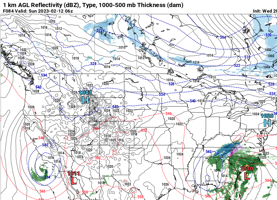
-
February 11-12 ULL Winter Storm
Upstate Tiger replied to Upstate Tiger's topic in Southeastern States
About to write the same thing. That would be a smart play at this point. This is the best Euro operational run yet. Tomorrow afternoon should give us some sort of sense plus we start getting in NAM range.


