

hawkeye_wx
-
Posts
6,664 -
Joined
-
Last visited
Content Type
Profiles
Blogs
Forums
American Weather
Media Demo
Store
Gallery
Everything posted by hawkeye_wx
-
My July rain total is 6.75". My June-July rain total is 15.79".
-
My 36-hr rain total is 4.29".
-
The Cedar Rapids area was the bulls-eye this morning. 2-3" of rain fell across the city. My total is 2.70". Up to 4" fell just east of the city. It was just pure heavy rain with no thunder. I love mornings like this. A few spots could get another 1-2" later today and tonight. July has been dry, but today's rain doubled my monthly total and we are now above avg.
-
The Cedar Rapids dew point is up to 84º. I think that's the highest since 1995.
-
I think this oppressively-humid air feels great (for 5-10 minutes) when I've been in AC for a while. I get cold inside.
-
Burlington is 92/85/120 Ames is 92/86/123 This is as high as the dew point ever gets around here. It's only 83 here.
-
This afternoon's line of storms was gusty, like the morning line, but it was weakening as it moved through and didn't last long. I only got 0.38" this time. We were not able to recover enough after the first line.
-
Today had potential to be the hottest day here, but the morning storms held the heat back in central and western Iowa.
-
-
Storms are really blowing up in north-central Iowa. They should side sse down the outflow boundary from this morning's storms. Cedar Rapids is well east into the morning cold pool, so I'm not sure if the storms will be able to get this far east.
-
We had a severe warning this morning. The wind was gusty, but it did not reach severe level.
-
This morning's storms were more robust than models predicted. I received gusty wind and a much-needed 1.10" of rain from a solid red line that swept through the area. I don't know if this line will ruin tonight's potential.
-
We finally got some clouds today. A tiny cluster of clouds popped, along with some showers, right over the Cedar Rapids area, and it kept bubbling for a couple hours. I only got 0.13", but the clouds were nice and it helped keep the temp down a bit.
-
GOES East on COD's website has been up and running for a couple hours.
-
GOES East is back up.
-
Another dying line of storms dropped 0.27" here last night, so I've only received 1.42" this month. The next two weeks look very dry. Some COCORAHS stations in far southern Iowa and northern Missouri are reporting 0.00" this month. Meanwhile, stations from central to northern Iowa and southern Minnesota have received several inches.
-
Our heatwave was 90, 91, 90, 91.
-
Most of the heavier rain has missed me over the last couple days, but I still accumulated a decent 1.15".
-
A bunch of rain fell just north and west of Cedar Rapids last night into this morning, but it's all crapping out before reaching us. I hope we can get something decent tonight because the next week looks dry again.
-
Bentley/Guyer were the names listed.
-
We've only managed to hit 90, 91, 90 the last three days, so pretty tame.
-
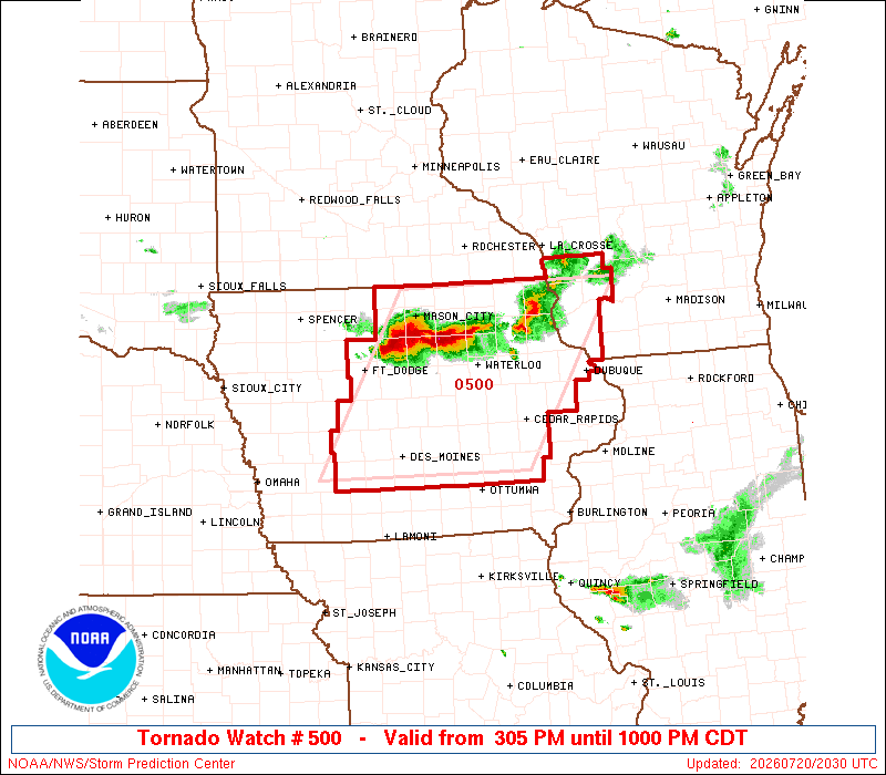
The SPC put out a meso discussion this afternoon for southeast Iowa into northern Illinois and southern Wisconsin, which included an 80% chance of a watch, which seemed odd. They were focusing on a band of cumulus through this area. However, the area is capped and no models have been predicting anything around here, only northern and western Iowa tonight. Nothing ever developed and the cumulus faded away.
-
DVN lowered us to 93 today, but we still came up short and hit 91.
-
The big question for us this week is when do the storms begin to reach our area. The Euro says Wednesday night, but other models say not til the weekend.
-
DVN had 95 for us today. We hit 90.


