

Met1985
-
Posts
16,909 -
Joined
-
Last visited
Content Type
Profiles
Blogs
Forums
American Weather
Media Demo
Store
Gallery
Everything posted by Met1985
-
Also tonight into tomorrow the winds are really going to pick up.
-
Here is the flooding aspect already coming into play. At Blantyre affecting Transylvania and Henderson Counties. ...Near Fletcher affecting Buncombe and Henderson Counties. .A complex storm system and associated cold front will impact the upper French Broad River watershed Saturday night through Sunday morning, resulting in periods of moderate to heavy rainfall. Storm-total accumulations of 3-5" are expected across the watershed. The resultant excessive runoff will likely cause the French Broad River from Rosman to Fletcher to approach or exceed Action/Advisory Stage, resulting in nuisance flooding of adjacent low-lying areas, including farmland, parks, greenways, boat-access areas, and golf courses. The most likely period of flooding is Sunday morning through Sunday evening, with conditions gradually improving later Sunday into Monday morning. There remains some uncertainty about exact amounts and isolated areas of Minor flooding cannot be ruled out, especially closer to Penrose, Blantyre, and Etowah. If the forecast significantly exceeds the Minor Flood Stage of 16.0 feet at Blantyre, a River Flood Warning may be issued. Stay abreast of the latest forecasts in case additional rainfall becomes likely.
-
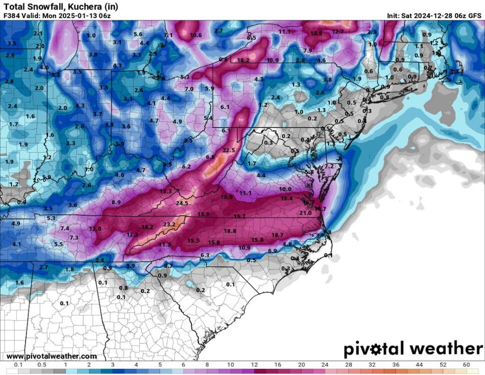
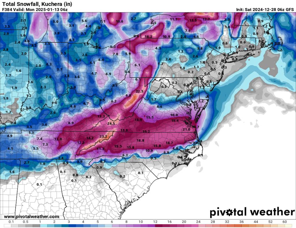
06z gfs wanting to give the viewing area anywhere from 1 to 2 feet plus of snow through the next two weeks... Sent from my SM-G998U using Tapatalk
-
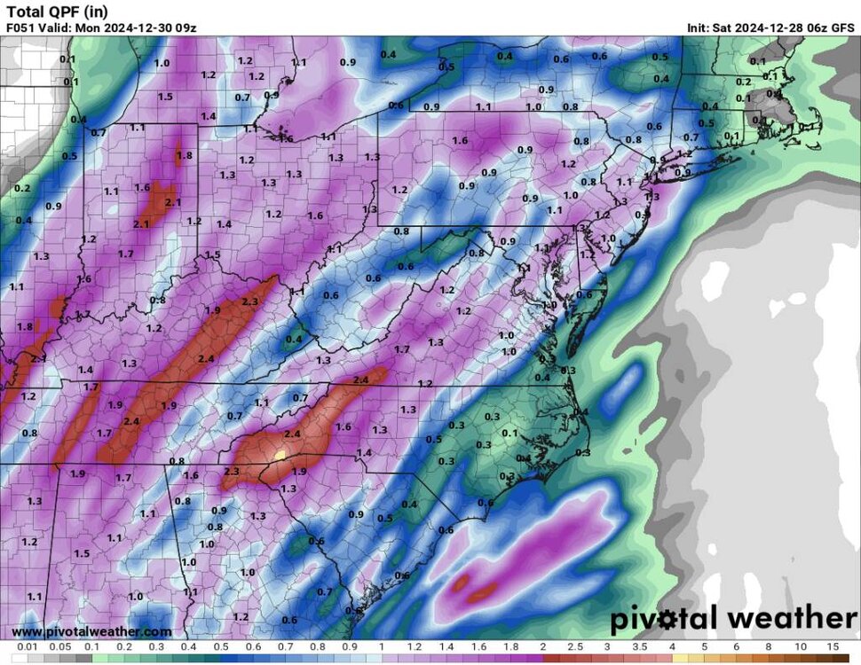
Before we get to dealing with the pattern change, we have a ton more rainfall ahead for us, especially in the southern mountains. Sent from my SM-G998U using Tapatalk
-
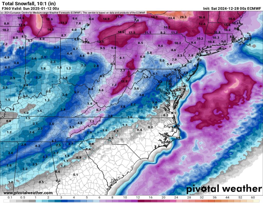
This is brutal cold. Having lows in the teen negative digits and highs below zero is insane. Also having snow on the ground... This is 10:1 ratio but the ratio would be much much higher than this. Sent from my SM-G998U using Tapatalk
.thumb.jpg.90574ffaab9ec1af19e81b16e38b498c.jpg)

-
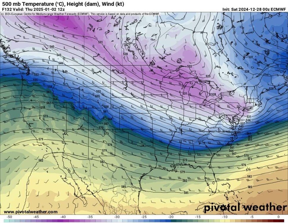
The 00z Euro is damn cold. I mean pipe busting frost bit northern blue cold. This would rival some records. Sent from my SM-G998U using Tapatalk
.thumb.jpg.8b7f70fc9397be2fb035dd0a58cca787.jpg)
-
Just glanced over the models and read some folks opinions for today. A couple things and I know most know this but we are in times that people can ride high or ride low with every model run. The key takeways is that the cold is coming and it might be really cold. The weeklies, eps, euro and cmc are dang cold. Second is please don't pay attention to any storm until maybe this coming Monday... Things will and have changed every single model run. To me we in the mountains are looking golden.
-
Yeah no freaking kidding along with some very cold weather.
-
Yeah I remember my mom telling me it was so cold engines were freezing up, and that everything just kind of came to a standstill.
-
Yeah I know they are trying to get campers in here for everyone who are still in tents. We've already had several mornings around 10 degrees this season.
-
The cold weather is coming. The rest will come into view in time.
-
Merry Christmas to the best crew on AMWX! I hope everyone has a wonderful day! Sent from my SM-G998U using Tapatalk

-
You get them through stormvista?
-
Post
-
Good Lord I must have been drunk this morning because my spelling was atrocious lol. A freaking beautiful day today.
-
Got down to 20 this morning. This month is going to be solidly below average.
-
Beautiful!
-
Yeah I'll take beautiful weather and the 50s at Christmas especially with the pattern loading up like it is towards the end of the month.
-
Everything looking great for the end of this month and 1st half of next month.
-
CMC has been looking good as well. Sent from my SM-G998U using Tapatalk
.thumb.jpg.650dabf52934ba93cccc9f0e8ab23fa1.jpg)
-
Euro at 12z is dang cold! Sent from my SM-G998U using Tapatalk
.thumb.jpg.f67ae36bd7ab60860176b4ea6d311811.jpg)
-
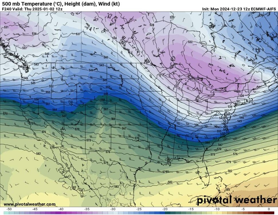
The Euro AIFS looks good in the extended period also. Sent from my SM-G998U using Tapatalk
-
The EPS has been and is currently beating the drum. Euro Weeklies continue to advertise a really nice pattern. Sent from my SM-G998U using Tapatalk
.thumb.jpg.44b6ae34cec85d7e403cfbdeb1b33981.jpg)
-
Yeah I saw that in the news. Awful news.
-
15 here this morning with a heavy frost.


.jpg.7d18e94d50f8d5845c5ad1b7e7c0bcdd.jpg)

.jpg.5b10c5382b22850921eca9e702755628.jpg)

.jpg.0de43daeeb0d324dd17f785e7ddd58b3.jpg)
.jpg.75fcf796ff3d93777c9e52a1093ed08f.jpg)

.jpg.5c51fe6ecb6091c6f6dc3fd237d2b1de.jpg)