

Met1985
-
Posts
16,909 -
Joined
-
Last visited
Content Type
Profiles
Blogs
Forums
American Weather
Media Demo
Store
Gallery
Everything posted by Met1985
-
 All in all good trends so far today. Got to feel good about this at this point.
 -
Yeah still some tweaks and improvements coming and I do think you are right with how the low tracks up the coast.
-
This is looking more and more like a classic setup.
-
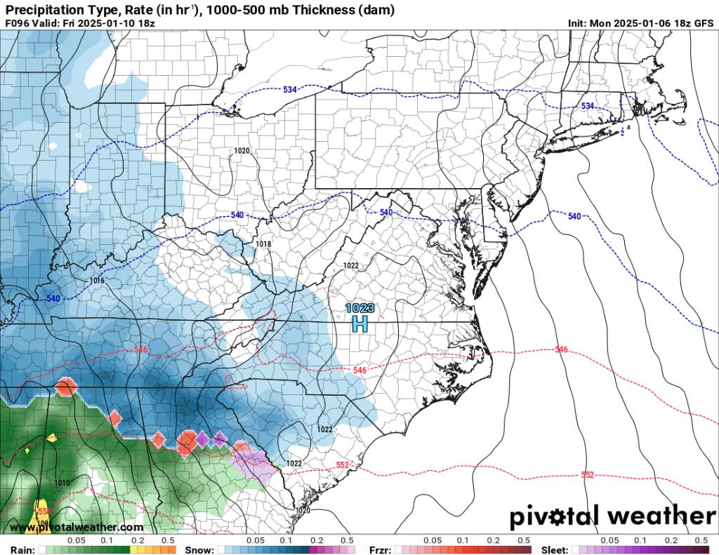
12z gfs looks dang good boys and girls! Sent from my SM-G998U using Tapatalk
-
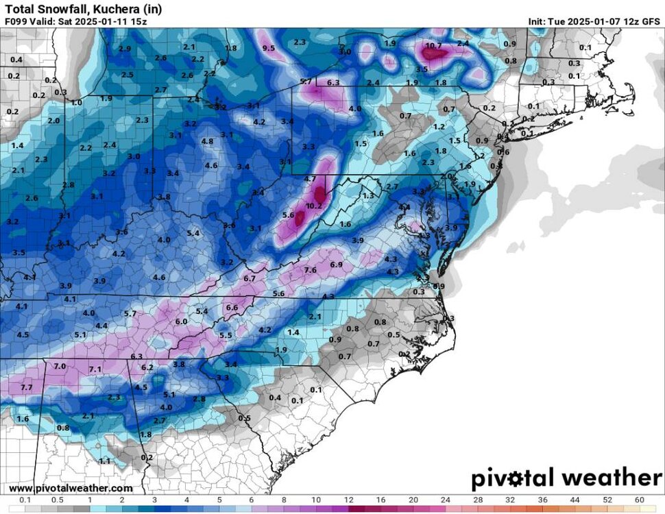
12z gfs snowfall. Sent from my SM-G998U using Tapatalk

-
12z gfs Sent from my SM-G998U using Tapatalk
.thumb.jpg.3c6e2eb66895bc1f99e026c96d928cb1.jpg)
.thumb.jpg.bb743b240a64c702287d249e67362f8d.jpg)
.thumb.jpg.8c7f9816e3f0362a48822f4b83f81277.jpg)
-
12z gfs Sent from my SM-G998U using Tapatalk
.thumb.jpg.9282908dcdad66f7ab22739f50d9523e.jpg)
-
This is going to be a great run region wide.
-
Yeah I am really hoping for a region wide snow.
-
Yeah you are right Don. I think a general 4-8 inches will be a good cover and will make a lot of people happy. We've got cold setting in now, snow on the ground and really leading up this is one of the best setups we've had in a long time.
-
That would be pretty conservative in my opinion. If it starts as snow here then it's more than likely going to stay snow. As Tony mentioned 3-6 with more in around the SW mountains.
-
A lot of the warm air advection comes from how the low travels. Prime track for NC is up along the coast. It keeps the warm air basically out to sea.
-
Just a beautiful landscape out there this morning with everything covered.
-
Nice!
-
With living in the SE we are almost always going to be fighting warm air but with snow to our west and north that helps a lot.
-
Looking like a possibility.
-
Hope yall get hammered over this way. This would relax a lot of snow weenies. Things should really come into focus tonight and into tomorrow morning with this storm. Today will be telling but hopefully good trends. So far so good.
-
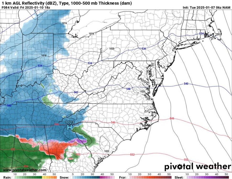
This look at the end of the NAM looks ripe. Obviously it 84 hour but just gives another snapshot of this system. I'd say things will really come into focus tonight into tomorrow morning... Sent from my SM-G998U using Tapatalk
-
Just looked out. Wind has died down and the temp is 17 degrees with 3 inches of snow in the ground. Still snowing moderately.
-
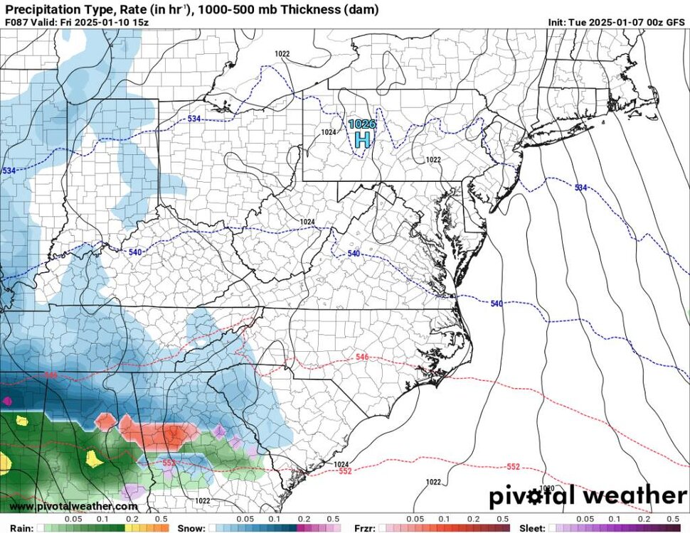
This looks solid from the 00z gfs. Sent from my SM-G998U using Tapatalk
.thumb.jpg.ce519dd94ff6501e3fbb73545547513c.jpg)
-
Just went out..hammering still. Closing in on 2 inches here. The flow has set my area up nicely.
-
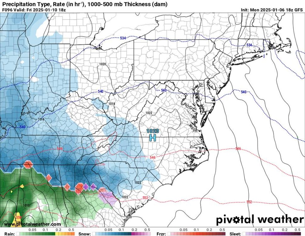
This looks like the ol 1, 2 punch this weekend from the 18z. Sent from my SM-G998U using Tapatalk
.thumb.jpg.fdffcb5e19e1979a9b3e23eab7944610.jpg)
.thumb.jpg.be15ef17cec5a1ee4428317bd4e7022e.jpg)
.thumb.jpg.389a656bf48d773bc472582e4e25df47.jpg)
.thumb.jpg.a3bfd6b5de2aefc35d87d764e0b018d5.jpg)
-
Upstream looks really good..we should have on and off snow all night.
-
Yeah that area specifically is very icy. Lots of black ice through there.
-
Just got home. Canton is coveted and still snowing. Home had 1.25 inch and it's hammering with a temp of 18 degrees. The wind is cranking.


.jpg.3604564f0991f3dae24c8268d5d1c71e.jpg)
.jpg.642cd38fd2e69cfcb2199da7d4a093c6.jpg)
.jpg.07b42d6bf7e379670262b8eb63cb6b6e.jpg)
.jpg.42e99a3a2bb00f50858cc74bfa64f1e5.jpg)


.jpg.123c4e251cbe7e089d5f255beb1e5486.jpg)
.jpg.9538a7c1d4f9a91f4d094b72350d8e09.jpg)
.jpg.db249900357fed885a3c71c236da6b03.jpg)
.jpg.8e0e6c12b36075beeed69b27587e2260.jpg)
.jpg.84483dc59b6271ddba10c940bdb2d1a3.jpg)