

Met1985
-
Posts
16,933 -
Joined
-
Last visited
Content Type
Profiles
Blogs
Forums
American Weather
Media Demo
Store
Gallery
Everything posted by Met1985
-
I've got no clue in that area but highlands is nice and sets up in elevation. There's still a lot to iron out.
-
Yeah ok 14 that's right.
-
You in district 13?
-
Ah nice! All that OT money.
-
I'd take 5 to 8 inches in a heartbeat. Especially with frozen ground and an arctic high moving in. Yes sir. Let's do it.
-
Mmmm yes you are in a decent spot I think but still early. But I do like the trends overnight and today.
-
Yes sir. Exactly!
-
Confidence is increasing... Sent from my SM-G998U using Tapatalk
-
It's winter. We cold.
-
Yeah I swore I was going to start a weather blog this season but between life and a big promotion at work I've not had a lot of time. Women also... Been busy there also lol.
-
They must be looking at just the low pressure because even without the low pressure forming we are still getting snow from the pv dropping down. These maps are stupid for us.
-
That would be significant.
-
You can't make the public happy...
-
This is exactly what's going to happen. People say they blew it big and we aren't going to get any snow this weekend. That's fine. At least you'll be able to find crap at the grocery store.
-
Yes sir especially with all the energy we are going to see.
-
Id say right now a conservative 3 to 6 inches. A lot of energy flying around..we've got energy coming down from the PV and then the low. Kind of a 1 two punch possibly.
-

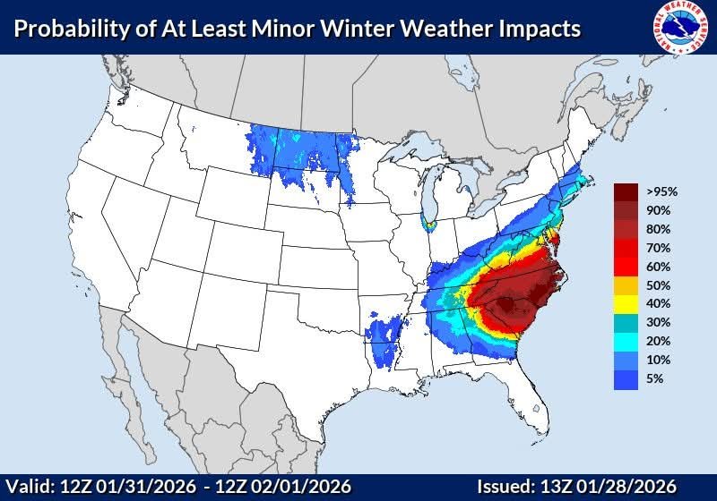
The “I bring the mojo” Jan 30-Feb 1 potential winter storm
Met1985 replied to lilj4425's topic in Southeastern States
It won't. Hopefully just slight movements north with such a strong arctic high. -
The “I bring the mojo” Jan 30-Feb 1 potential winter storm
Met1985 replied to lilj4425's topic in Southeastern States
You shouldn't be surprised. -
Also for the near future we will see a reinforcing shot of cold air and the high elevations may see some flurries tonight.
-
Obviously having the Euro bite is huge for us. A cold ground, a true arctic high building in, high winds. This has all the makings of a fun weekend.
-
Shouldn't be any with the moisture coming from the East.
-
Regardless of if this system throws moisture back our way it looks like we are going to have a few impulses that come through here with the PV lobe. I don't think it will just be flow snow either.
-
The “I bring the mojo” Jan 30-Feb 1 potential winter storm
Met1985 replied to lilj4425's topic in Southeastern States
Doesn't look good fellas. -
The “I bring the mojo” Jan 30-Feb 1 potential winter storm
Met1985 replied to lilj4425's topic in Southeastern States
Are there public records were we can look at the verification scores? -
The “I bring the mojo” Jan 30-Feb 1 potential winter storm
Met1985 replied to lilj4425's topic in Southeastern States
Also on that note I wouldn't believe anything the GFS spits out until about 2 days before the event.


