

Met1985
-
Posts
16,674 -
Joined
-
Last visited
Content Type
Profiles
Blogs
Forums
American Weather
Media Demo
Store
Gallery
Everything posted by Met1985
-

2022-2023 Fall/Winter Mountains Thread
Met1985 replied to BlueRidgeFolklore's topic in Southeastern States
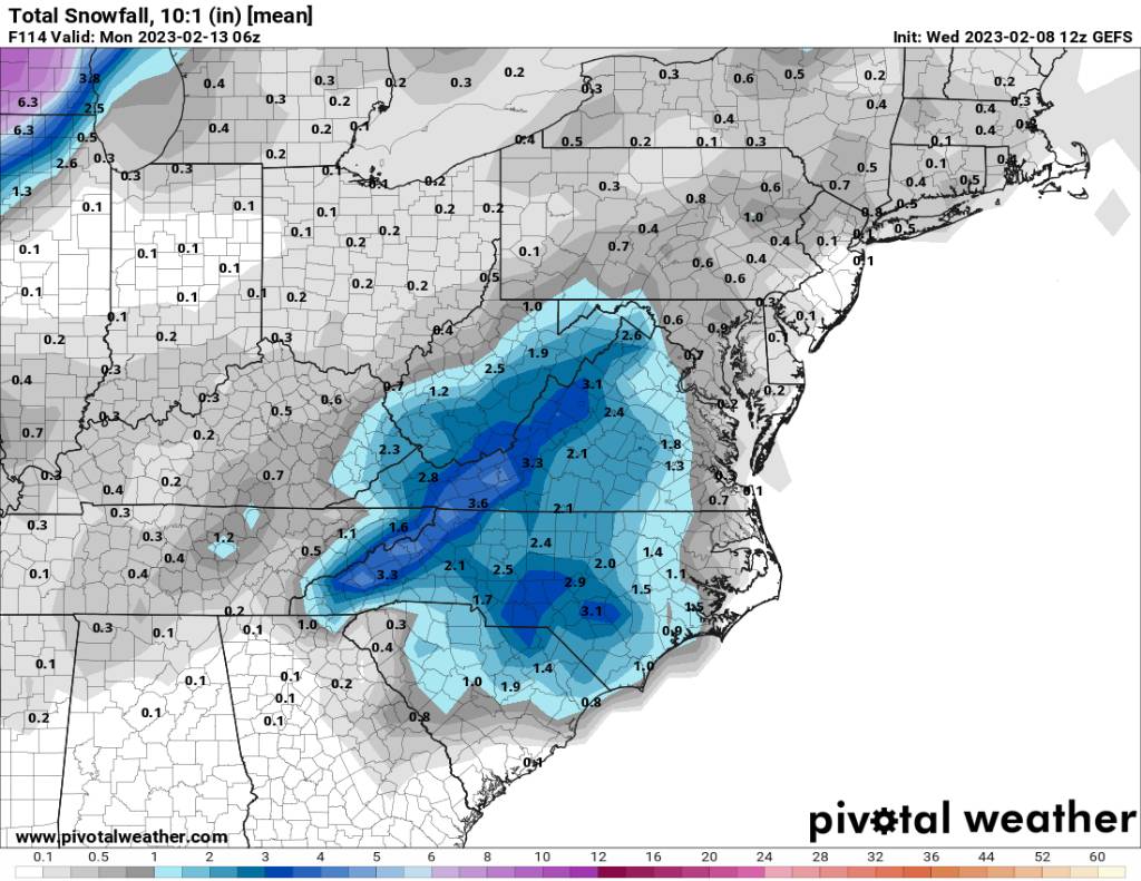
18z gfs snowmap Sent from my SM-G998U using Tapatalk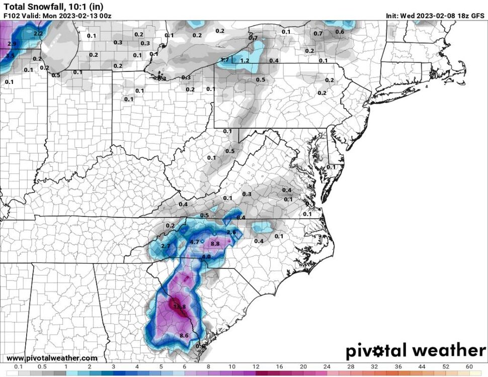
-
2022-2023 Fall/Winter Mountains Thread
Met1985 replied to BlueRidgeFolklore's topic in Southeastern States
Lol congrats middle Georgia and South Carolina. -
2022-2023 Fall/Winter Mountains Thread
Met1985 replied to BlueRidgeFolklore's topic in Southeastern States
Dang it is isn't it. Nice catch. -
2022-2023 Fall/Winter Mountains Thread
Met1985 replied to BlueRidgeFolklore's topic in Southeastern States
Yeah no kidding! This is a classic synoptic look for us. We can get big snows from this type setup but it's been years since we've had one roll through that looks like this. -
2022-2023 Fall/Winter Mountains Thread
Met1985 replied to BlueRidgeFolklore's topic in Southeastern States
Hunters video. https://youtube.com/watch?v=9NJU7_fFGUE&si=EnSIkaIECMiOmarE -
2022-2023 Fall/Winter Mountains Thread
Met1985 replied to BlueRidgeFolklore's topic in Southeastern States
Yeah Hunter it's great to see the euro and eps jump on board big time. -
2022-2023 Fall/Winter Mountains Thread
Met1985 replied to BlueRidgeFolklore's topic in Southeastern States
Another damn great trends on the model runs today. We have the cmc, icon, the gfs, GEFS, the euro, and the eps all putting us in a favorable situation this weekend. And this is all under 4 days now. -
2022-2023 Fall/Winter Mountains Thread
Met1985 replied to BlueRidgeFolklore's topic in Southeastern States
Yeah by this for sure but im very suspect of any great snowfall outside the mountains. -
2022-2023 Fall/Winter Mountains Thread
Met1985 replied to BlueRidgeFolklore's topic in Southeastern States
The 12z gefs snowfall means looks good for the mountains. Sent from my SM-G998U using Tapatalk
-
2022-2023 Fall/Winter Mountains Thread
Met1985 replied to BlueRidgeFolklore's topic in Southeastern States
Oh yeah for sure. I think a general 4 to 8 inches across the region and people would be happy with that. -
2022-2023 Fall/Winter Mountains Thread
Met1985 replied to BlueRidgeFolklore's topic in Southeastern States
Yeah we sit in a better spot for sure. You'll probably be on the line on big snow or slop but in the valley or flat lands I don't see it. -
Yeah I just posted the cmc snow map and it gets yall involved and to me a more realistic look at this point. I think it does slow especially when turning negative tilt.
-
2022-2023 Fall/Winter Mountains Thread
Met1985 replied to BlueRidgeFolklore's topic in Southeastern States
Realistically I see the cmc working out much more than I do the gfs. I really don't see down East getting that much snow with marginal temps outside the foothills. -
2022-2023 Fall/Winter Mountains Thread
Met1985 replied to BlueRidgeFolklore's topic in Southeastern States
The 12z cmc absolutely hammers us with its track. Sent from my SM-G998U using Tapatalk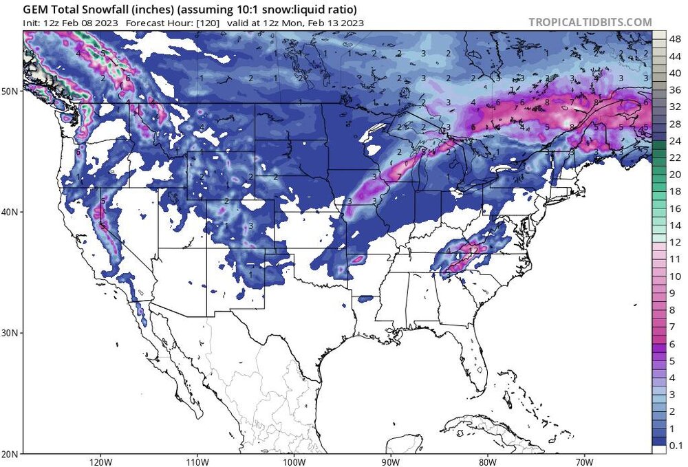
-
I do think it's being too progressive at this point. I think it'll correct today or tomorrow.
-
Yeah you are possible right. Especially in February there may be something weird about it.
-
2022-2023 Fall/Winter Mountains Thread
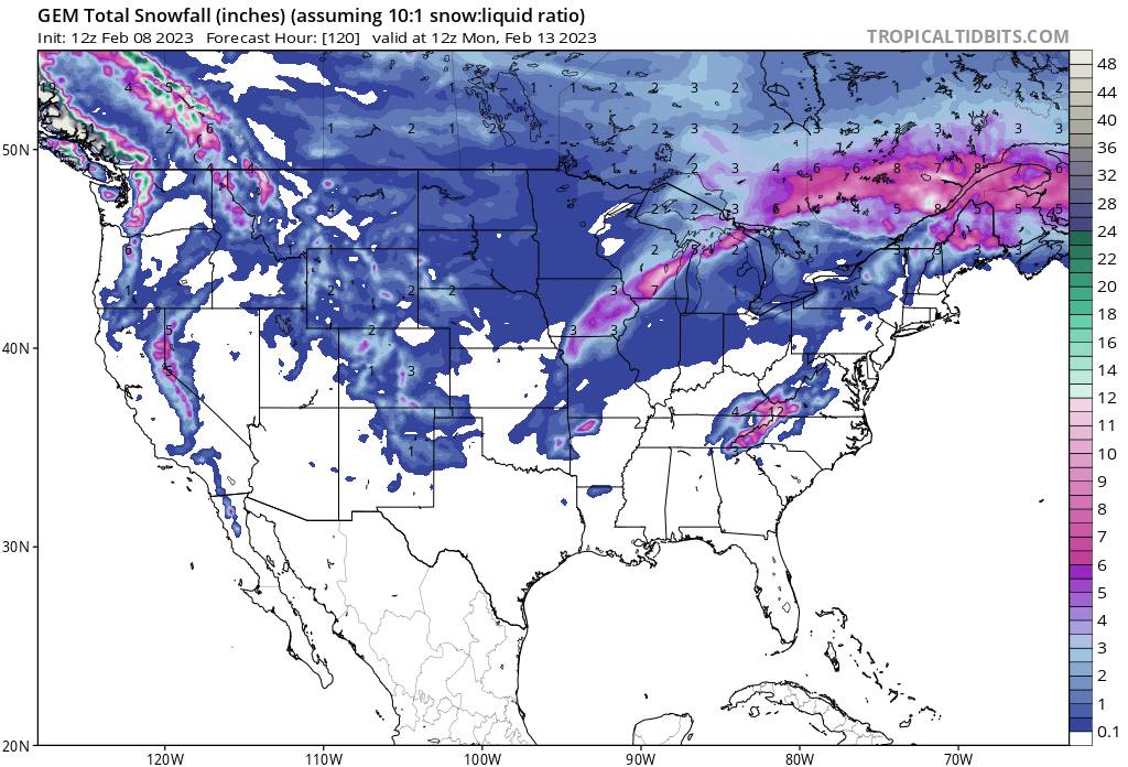
Met1985 replied to BlueRidgeFolklore's topic in Southeastern States
For what it's worth this is the latest Icon model. A decent hit for most. Sent from my SM-G998U using Tapatalk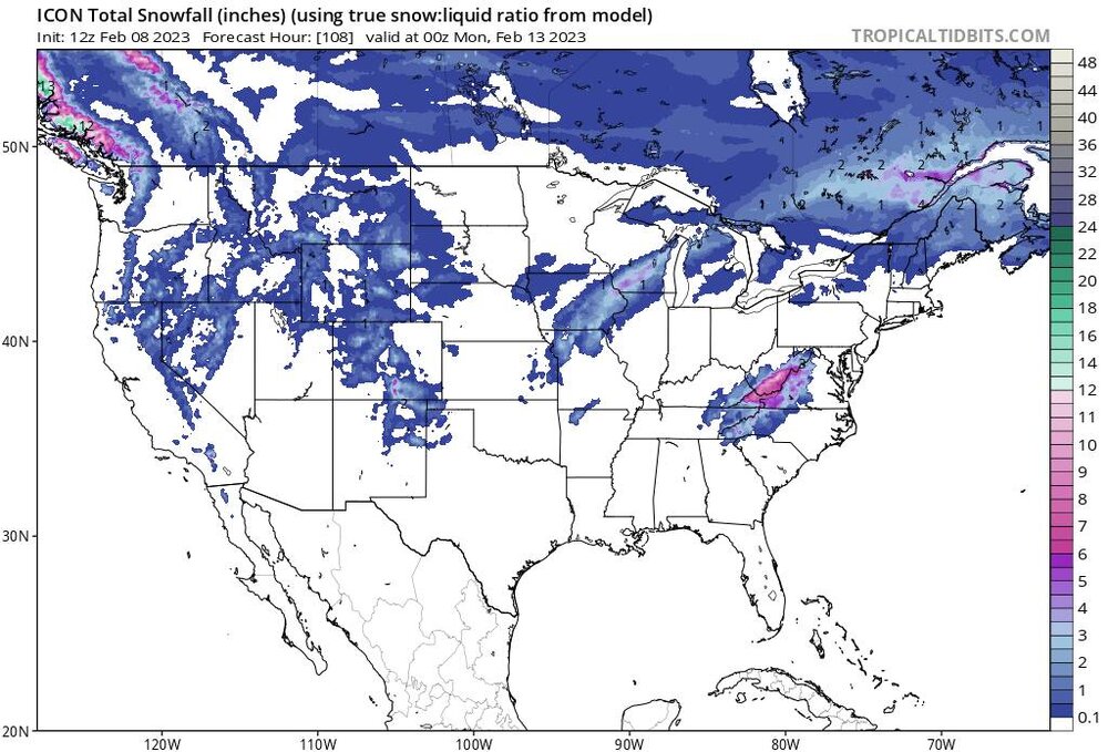
-
That's a great question for sure Carver. Im not sure myself but maybe @GaWx could come up with something.
-
2022-2023 Fall/Winter Mountains Thread
Met1985 replied to BlueRidgeFolklore's topic in Southeastern States
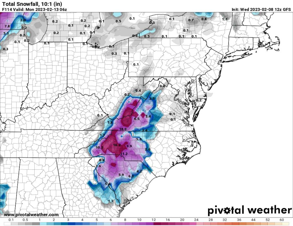
Snowfall map from 12z gfs Sent from my SM-G998U using Tapatalk
-
2022-2023 Fall/Winter Mountains Thread
Met1985 replied to BlueRidgeFolklore's topic in Southeastern States
Hour 102 on gfs Sent from my SM-G998U using Tapatalk.thumb.jpg.f786bfb6b318f42b71210656547ed170.jpg)
-
2022-2023 Fall/Winter Mountains Thread
Met1985 replied to BlueRidgeFolklore's topic in Southeastern States
Hour 96 on gfs Sent from my SM-G998U using Tapatalk.thumb.jpg.c9ff484b1ef0b18aba9a23c882e2a5e0.jpg)
-
2022-2023 Fall/Winter Mountains Thread
Met1985 replied to BlueRidgeFolklore's topic in Southeastern States
Hour 90 on gfs Sent from my SM-G998U using Tapatalk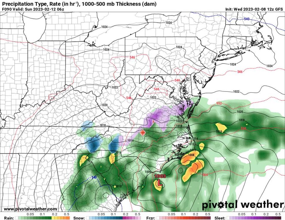
-
2022-2023 Fall/Winter Mountains Thread
Met1985 replied to BlueRidgeFolklore's topic in Southeastern States
At hour 78 on gfs Sent from my SM-G998U using Tapatalk.thumb.jpg.b196c906a1aee7c38b46ccae5980c27a.jpg)
-
2022-2023 Fall/Winter Mountains Thread
Met1985 replied to BlueRidgeFolklore's topic in Southeastern States
This run is very similar to the 06z run. Looks like a big hit further east and into Upstate SC. The piedmont looks good also. -
2022-2023 Fall/Winter Mountains Thread
Met1985 replied to BlueRidgeFolklore's topic in Southeastern States
Currently this run is further south and we are just on the northern edge of the precip shield. Mostly rain.


.jpg.035827b25107dc94667eeac5271328f4.jpg)
.jpg.3272e9cac86bf19f4f2281ea7e87b205.jpg)

.jpg.5beb2a3d9948671581aa92b85fb08c27.jpg)