RogueWaves
-
Posts
2,559 -
Joined
-
Last visited
Content Type
Profiles
Blogs
Forums
American Weather
Media Demo
Store
Gallery
Everything posted by RogueWaves
-
DTX Frontal passage around or just after midnight, as deepening surfacelow tracks into Lake Huron tonight. Strong high res model consensus(RAP/3k NAM/ARW/ARW2/HRRR/Euro) with the low deepening to around 975MB by Monday morning near Georgian Bay. With at least 55-60 knots offlow at the 850 MB level, confidence is high in occasional windgusts of 45-55 MPH throughout Monday, with a surface trough passagearound mid day also likely providing a focus. Steepening low levellapse rates and inversion heights aoa 7 kft, along with much of thecloud depth/minimal cape in the dgz will be conducive to snowshowers/squalls, and isolated wind gusts to 60 MPH seem likely in theconvective rolls. With the soaked ground from today`s rainfall,weakened tree limbs from the ice storm, and long duration of strongwind gusts tonight through early tomorrow evening, have elected to gowith high wind warning for all of southeast Michigan. Expecting tosee a significant number of power outages. 6z Euro ensemble meteogramsindicating close to the half members supporting 55-60 MPH peak windgusts as well.The strong winds and snow squalls will make for tough travelconditions on Monday, despite just an inch or two of snowaccumulation as 700 MB cold pool (-20 C)/trough axis tracks through.Any leftover standing water will also freeze for the Monday morningcommute as temps fall into the upper 20s.
-
Afd said 32F here by noon - still holding at 30F so warming running a bit tardy. Super icy here coating everything. Cannot remember going into a storm with such even tho most or all should be melted later.
-
You're not under a Bliz Warning so no, not a full-fledge Blizzard. Your warning calls for 4+ inches of wind-driven snow with periods of blizzard-like conditions. Have fun with it.
-
On the southern fringe for this one. Added to my existing tree ice overnight. Still below freezing but expecting a roughly 12 hr window reaching into the upper 30's. If the ground glacier can hold on the 3" of wind-blown snow tomorrow could at least make for some potential drifting. Storm Warning just a half county NW of here. Overall amounts have trended up on the regional NWS forecast map (a little bit may be from weaking clipper Tue/Wed fwiw)
-
Wishing a road trip was in the cards tbh.
-
Check your posts from last Feb. I remember when one of the TOR crew said they had 26" depth you asking if that was the deepest he ever seen? Would be in the thread for the last event for which GRR had me under a Watch, only to cancel it by the next update when it became obv the storm wasn't going to get its act together in time for SWMI. Then even DTX said "miss SE stank" after AFD's were talking crippling bliz for the Thumb. It all ended up hitting TOR. Oh, and yeah another WWA from my office. Can I redeem 3 of them for Warning?? Going back two years almost, every county around Clare has gotten a Warning. Clare stands alone as the only county without one. On an island here, lol.
-
Technically NO, only 3 yrs since the pre-Christmas bomb. You know, the one that was forecast to bomb much earlier and actually be a legit bliz for The Mitt. Instead it finally got going good up in Canada and serious wind-driven +SN was confined to the usual LES Belts of both peninsulas. LP is way over-due for a wound-up powerhouse storm, to say nothing of a CAT-5 (20+) storm that delivers such to more than a couple county region like Jan '99. You can add another 1,095 days for SEMI/DTX since this map in '22
-
Thanks for confirming my original post on this. Big Dog's in the Midwest is 15"(+/-) but setting the bar at 12" for DTW is much more realistic. DTX/White Lake/M-59 on north has held its own over the decades with the rest of the MW neighborhood. South of that gets plenty of snowstorms as you've noted, but over history the BD's are much less frequent for that region. As I've said before and you know, I am as much a fan of getting and maintaining a decent snowpack as I am of the larger storms. So far since my relocation here, I've gotten mostly the first and not much of the second. The impending storm is another fine example of that. I realize Harrison is not BD haven, but the way powerhouse storms have been shirking the LP of MIchigan the past 6 winters is getting really annoying. Toronto gets back-2-back BD's and now Yooperland about to do the same. Nothing is taking the sweet-spot track for us - nothing.
-

Winter 2025-26 Medium/Long Range Discussion
RogueWaves replied to michsnowfreak's topic in Lakes/Ohio Valley
Because you've already gotten a big storm. DTW/TOL haven't. -
Winter 2025-26 Medium/Long Range Discussion
RogueWaves replied to michsnowfreak's topic in Lakes/Ohio Valley
20mb in 12 hrs per today's runs. I'm voting for the more SE track vs the ones that nuke Yooperland. Bout time the SE trend works in favor for once. -
Northern 2/3rds of DTX's CWA has had plenty of Big Dogs over the years. Its the southern 1/3rd that really struggles to put it all together.
-
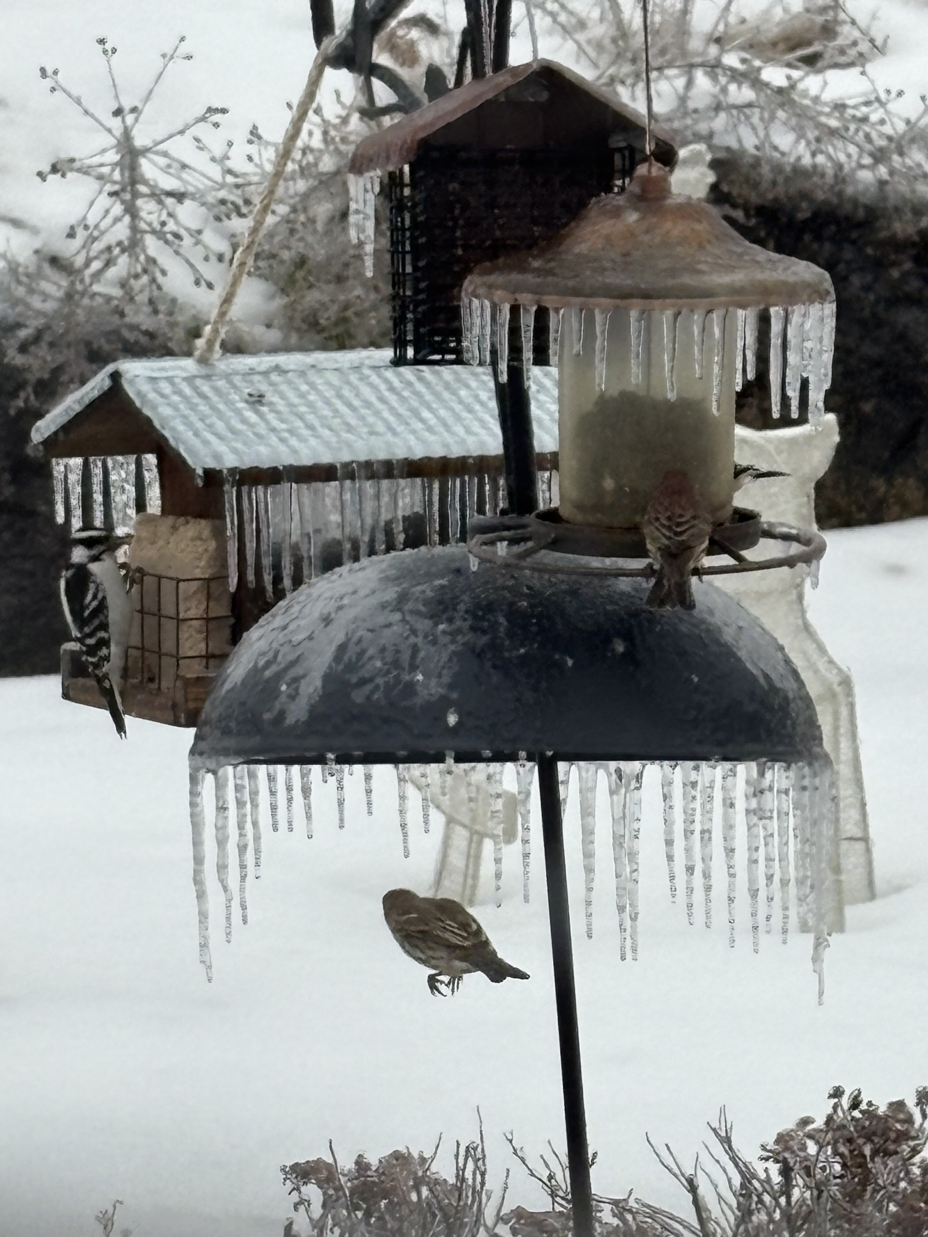
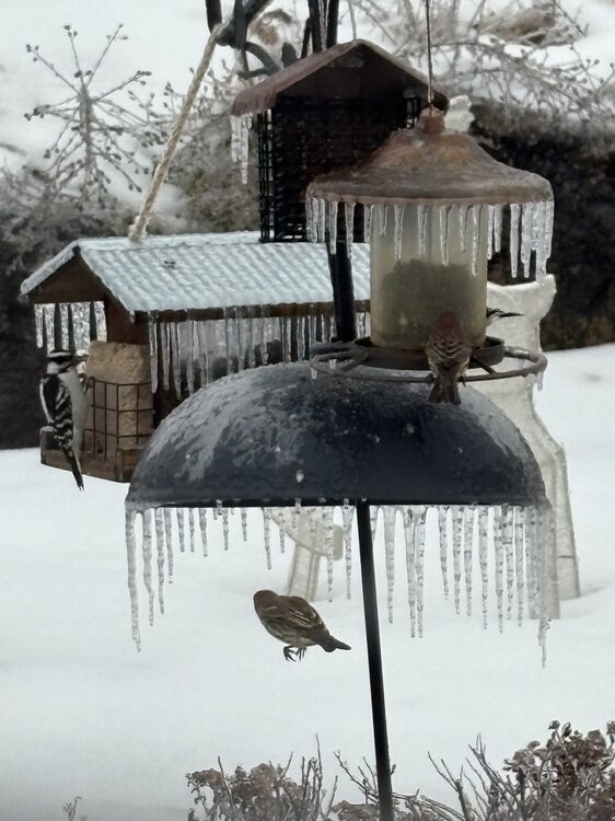
Not a fan of ice but it has some photogenic qualities. Might strengthen the meager snow cover a bit too. This morning was legit.
-
Winter 2025-26 Medium/Long Range Discussion
RogueWaves replied to michsnowfreak's topic in Lakes/Ohio Valley
Scenic icy up here with snow still plus icicles on every tree limb. Downstate prolly fits your description well. Supposed to remain below freezing until Sunday so we could keep this look for a day or so. -
High here of 32.7F was just after midnight, we've been at/below freezing since 12:30 am. While not postcard quality outside, its still nice to see snow covered ground. Its making my Christmas just a bit merrier to see my yard decorations sitting in snow vs the green stuff! Plenty of other days on my calendar for that. Hope everyone can have a Merry Christmas whatever your wx.
-
Jan '99 prolly belongs on that list as well.
-
1.5" today and the 19th straight day below freezing. That streak is scheduled to end tomorrow just as my snowpack is looking the best so far. Expecting to loose/settle a lot of it by Thursday evening when the cold shot makes it way back in here. Been a great stretch really.
-
8” otg with 16” drift in the back garden. It means boots required conditions to reload my bird feeders. Beautiful winter day this afternoon.
-
December 11th-14th Double Banger Clippers
RogueWaves replied to Jackstraw's topic in Lakes/Ohio Valley
Drove thru a drift back in November on a side street and a sheet of snow flew up on my windshield - most fun since I owned snow sleds years back. I understand why you like it LOL -
Warm ground really hurts. These sudden plunges into a snowy pattern seem like a win but don't allow time for the ground to freeze properly. Jan '24 ground was so warm our solid 10" storm was down to 6" just 3 days later when the 2nd storm hit. I never realized GHD-1 melted off so quickly over there.
-
Winter 2025-26 Short Range Discussion
RogueWaves replied to SchaumburgStormer's topic in Lakes/Ohio Valley
Same model games we just endured the last 48 hrs -
Two day new snow here is 7-8" and its a winter wonderland out there. Never got out of the mid-20's and flakes were more like tiny LES again. Nothing says winter like a solid snow on top of a decent snowpack.
-
The good old front-end thumper for SMI. Should stay all snow and avoid dreaded melting for Harrison. Clipper 1 was a solid 2" and on the high end of forecast for a change. Snowpack was quite withered after 9 days with warm ground eating from beneath. Great to be back. See if this one can sneak those top shelf rates up here too.
-
-3 at home, -17 at work in Grayling with co-worker reporting he had -20F along the lowlands eastward.
-
That Civil Danger WARNING - is that due to your governor?
-
Dec 6-7th (It's not a clipper) Clipper
RogueWaves replied to Chicago Storm's topic in Lakes/Ohio Valley
vs 58" two counties west - yeah ouch. Marshall came back with some great months for me during my 19 yrs there but missed the biggest one by 17 mos moving there in May of '02.