RogueWaves
-
Posts
2,559 -
Joined
-
Last visited
Content Type
Profiles
Blogs
Forums
American Weather
Media Demo
Store
Gallery
Everything posted by RogueWaves
-

Dec 6-7th (It's not a clipper) Clipper
RogueWaves replied to Chicago Storm's topic in Lakes/Ohio Valley
Not even 1/3 of the way so outcomes rivaling 2000 are still on the table. Tbh, I thought DTW was kinda screwed out of a lot of the big action in 2000. -
Dec 6-7th (It's not a clipper) Clipper
RogueWaves replied to Chicago Storm's topic in Lakes/Ohio Valley
@michsnowfreak I did better with the Nov storm but you've now gotten 360% of my Dec total. It's all relative, lol. Certainly right there with you regarding life in the shadow of IA/IL/WI hot zone. Other than Dec '74 Detroit is not known as huge front end winter paradise. More so the back half. Your F/M/A avg's are better than I had in Marshall. -
Dec 6-7th (It's not a clipper) Clipper
RogueWaves replied to Chicago Storm's topic in Lakes/Ohio Valley
After watching the last two systems miss SW I'm hoping to at least catch you IL crew this week. -
Dec 6-7th (It's not a clipper) Clipper
RogueWaves replied to Chicago Storm's topic in Lakes/Ohio Valley
Where did CAD go all of a sudden? -
Winter 2025-26 Short Range Discussion
RogueWaves replied to SchaumburgStormer's topic in Lakes/Ohio Valley
Scoring today:
-
Winter 2025-26 Medium/Long Range Discussion
RogueWaves replied to michsnowfreak's topic in Lakes/Ohio Valley
And not 300+ hours away, lol -
Gonna suck going back to regularly scheduled Decembers
-
Nov 28-30th Post Turkey Day Winter Storm
RogueWaves replied to Chicago Storm's topic in Lakes/Ohio Valley
Not remembering a November storm fitting that description from 19 yrs in Calhoun Cnty, when was that? -
Nov 28-30th Post Turkey Day Winter Storm
RogueWaves replied to Chicago Storm's topic in Lakes/Ohio Valley
Midnight 1st measure was 3.8" up here. Good stuff didn't start til sometime late evening. -
Nov 28-30th Post Turkey Day Winter Storm
RogueWaves replied to Chicago Storm's topic in Lakes/Ohio Valley
Is this winter storm Brutus? -
Nov 28-30th Post Turkey Day Winter Storm
RogueWaves replied to Chicago Storm's topic in Lakes/Ohio Valley
Dust in the wind for 3 hrs has whitened everything. Streets, rooftops, and lake ice. -
Nov 28-30th Post Turkey Day Winter Storm
RogueWaves replied to Chicago Storm's topic in Lakes/Ohio Valley
I need it north and so far it should be just right. 9" in my text is a nice increase from where this started. -
Nov 28-30th Post Turkey Day Winter Storm
RogueWaves replied to Chicago Storm's topic in Lakes/Ohio Valley
Welcome to that 70's show -
Fall 2025 Medium/Long Range Discussion
RogueWaves replied to Chicago Storm's topic in Lakes/Ohio Valley
I may be one of the few hoping to whiten the ground from the first storm. Backside Wed evening overnight to Thanksgiving morning "may" bring a streamer burst or two if things line-up just right. NCEP says I have a chance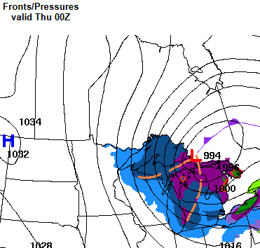
-
Absolutely they've looked/been worse but last year was cold and slightly AN snow for my area including a solid white Christmas but Dec climo is much stronger here as well. Second morning in the mid-teens and large ponds held ice all day despite ample sun. Matter of time now and seeing if a decent system can come together to kick-start the December party.
-
Worked in Ft. Worth back in May of 2010 and there were photos in the Starbucks of full-sized snowmen they had made during the Dec '09 storm fwiw
-
Chicago is the new Buffalo!
-
So you experienced MP's last Big Dog in Feb '08?
-
Fall 2025 Medium/Long Range Discussion
RogueWaves replied to Chicago Storm's topic in Lakes/Ohio Valley
Looking less snoozy up here and globals even throwing out random snow risks during this period. N stream so nothing heavy but at least it will look and feel more the season. -
Had a vivid rainbow right after +RN squall at 44 degs here. Qpf over-performing as well
-
-
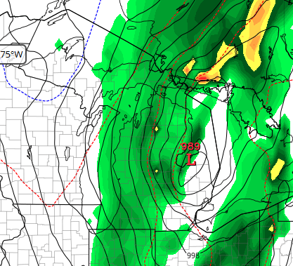
Euro weakest sauce at 989 mb for Sunday
-
Might be something this weekend - finally?
-
More BS backwards spring on deck here tomorrow
-
1988 with its 113F heat index in Flint area was for me the worst because I had zero A/C. Not at home (a mobile tin can at the time no less) not at work (top floor of an old building) and not working in the used car I was driving. 1995 was a brief deal since I was in NMI then. The afternoon of the derecho it did hit 100F in Traverse right before, then dropped to a chilly 59F right after. 2012 was rough but I had A/C home/office/car so I faired way better than my lawn which basically half of it was gone afterwards. G-maps street scene used to be from that summer and my front lawn looked horrendous.