RogueWaves
-
Posts
2,559 -
Joined
-
Last visited
Content Type
Profiles
Blogs
Forums
American Weather
Media Demo
Store
Gallery
Everything posted by RogueWaves
-

Winter 2024-25 Medium/Long Range Discussion
RogueWaves replied to michsnowfreak's topic in Lakes/Ohio Valley
That late 70's hang-over winter. I ofc have mentioned it more than once. Why do people remember the tri-fecta 77/78/79 winters more than any other single winter? Because, even if 2 of 3 weren't great snow seasons for DTW, those winters were making headlines in nearby places like Buffalo and Chicago. Those winters scored a lot of historic news headlines for our region, tho as you've said, Detroit was never the bullseye as in 13-14. -
Winter 2024-25 Medium/Long Range Discussion
RogueWaves replied to michsnowfreak's topic in Lakes/Ohio Valley
My Feb 2015: 26.9" snow, CAT-4 Big Dog storm, Blizzard, and five days with dbl-digit below zero readings. An honest to goodness winter month if ever there was one. I'd gladly take a repeat. Edit - forgot to mention excellent deep snow cover thrown in for good measure. -
Winter 2024-25 Medium/Long Range Discussion
RogueWaves replied to michsnowfreak's topic in Lakes/Ohio Valley
CPC with a slight risk of a heavy snow swath on their 8-14 day map. That's as high as you can go for now. As posted, these windows have flashed before and didn't work out. Have to give it some time to trend better or join the scrap heap of prior fails. -
Winter 2024-25 Medium/Long Range Discussion
RogueWaves replied to michsnowfreak's topic in Lakes/Ohio Valley
IF this manages to thread the needle, it would be crazy short considering the drums were beat that it would be ruining winter. Finally lost my snow this morning. I expected it to be gone b4 Christmas a week ago.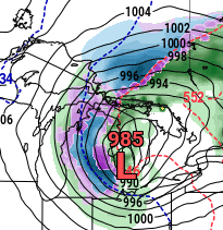
-
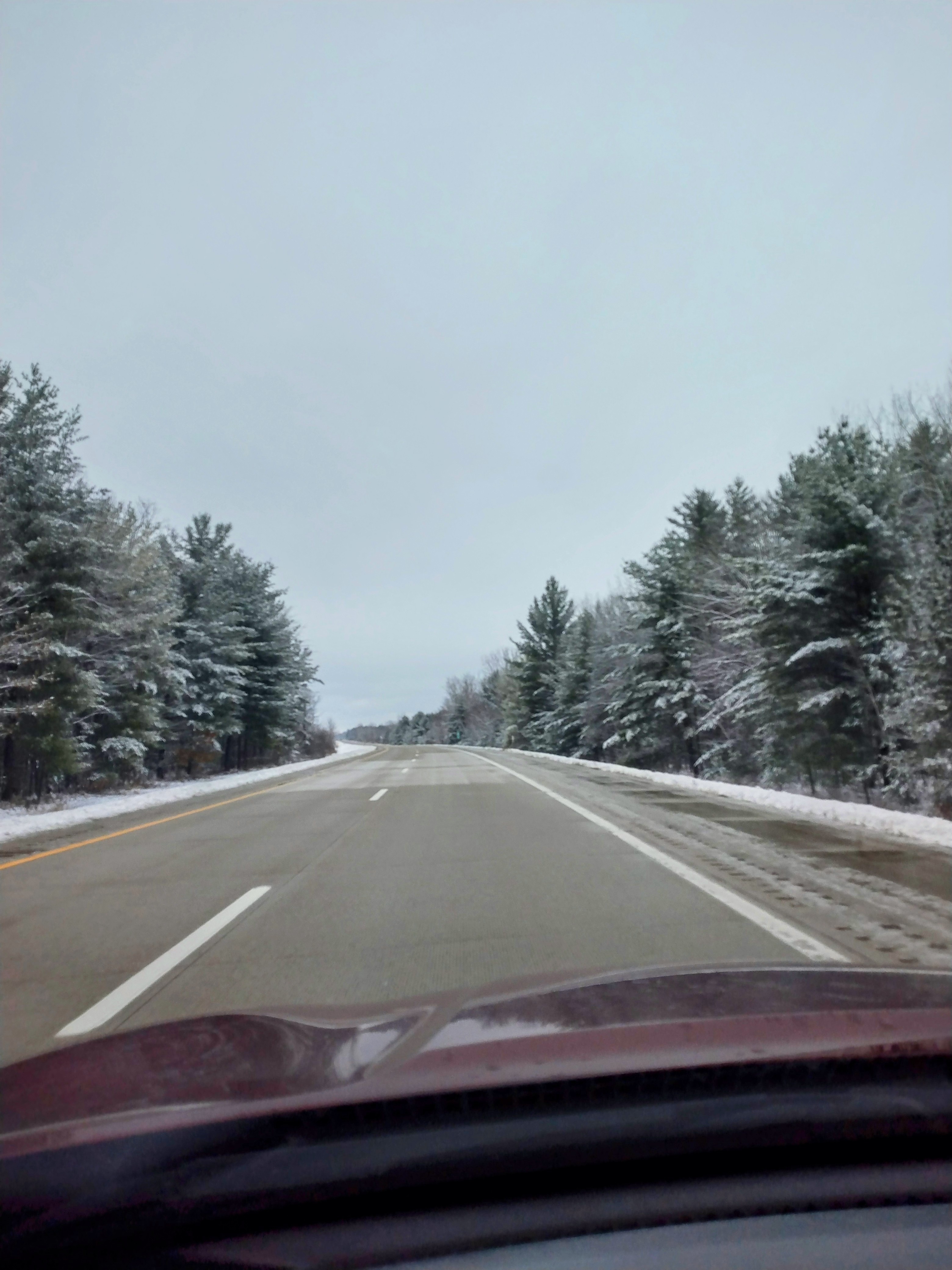
Sorry for crappy cell pic, but Merry White Christmas to everyone!

-
Winter 2024-25 Medium/Long Range Discussion
RogueWaves replied to michsnowfreak's topic in Lakes/Ohio Valley
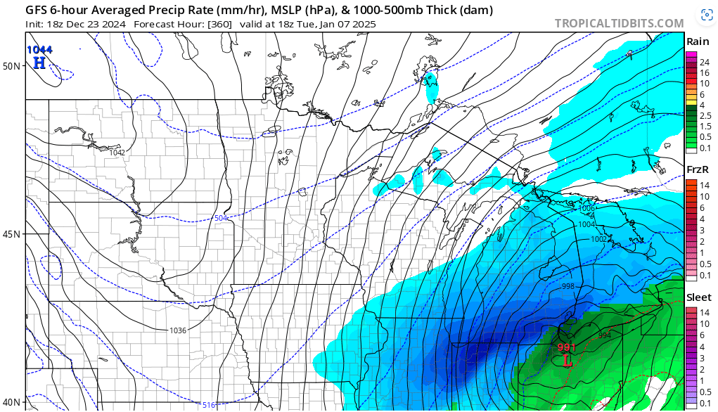
Might be the first such fantasy storm of the winter: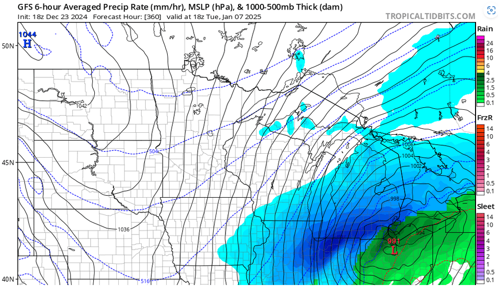
-
Not setting any records (imby), but yeah, it's been cold with at least some snow cover 24 days since the arctic intrusion at Thanksgiving. And I have 5-5 1/2" depth for my Whitest Christmas in 7 yrs. Hard to complain with this past decade of duds.
-
Awaiting a final call but pretty sure I went AN for the season after today's storm. Iirc when this system was first flashed it was just a rainer here so score one for #winter
-
Let’s talk winter!! Ohio and surrounding states!! 24'-25'
RogueWaves replied to buckeye's topic in Lakes/Ohio Valley
Boxing Day Blizzard of 2012? -
That's what holiday lights are for, lol. They do help my mood anyways
-
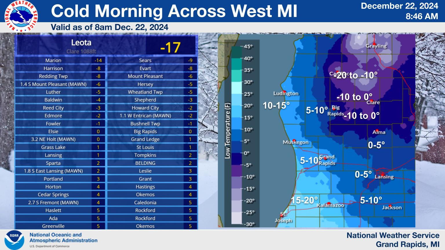
My coldest December morning (-10F) since December of 2013 downstate. We took the "cold cake" in GRR's CWA. I'm in a low spot down at lake level vs what they show for Harrison. The "hoar frost" was impressive but I wasn't dressed to go out and snag a photo.

-
-3F here attm. The Clipper held together pretty well for a lot of S and Central Mich. And with the bulk falling over night, it wasn't trashed by traffic and salt trucks so the parking lot piles are unusually pristine white and it's been cold so remain fresh. Not record setting, but so much better than most of our Dec's of late. Despite a couple torchy thaws, all the lakes are ice and snow covered. Not sure about large ones like Houghton but the lakes here I see daily.
-
Some 6-7" totals close to GR. Yet another synoptic storm miscue. They have said they prefer forecasting LES events because it's more straightforward - cold wind blows over warm lake = snow Sorry. I do NOT miss Wayne county winters. Wintry paradise this evening up here. Maybe Monday evening will deliver? SEMI's been known to get some of their best thumps as it's about to warm up.
-
Winter 2024-25 Medium/Long Range Discussion
RogueWaves replied to michsnowfreak's topic in Lakes/Ohio Valley
Sort of seems like that right? ENSO background (or expected) and that's it. While the precip screams Nina, I think they tinker more with temps. -
Winter 2024-25 Medium/Long Range Discussion
RogueWaves replied to michsnowfreak's topic in Lakes/Ohio Valley
Didn't that happen a few days before the infamous Chicago bliz of '67? Even had a TOR in WI iirc -
Winter 2024-25 Medium/Long Range Discussion
RogueWaves replied to michsnowfreak's topic in Lakes/Ohio Valley
Crazy that on the opposite corner of The Mitt I was living the snowiest non-stop winter of my life with 220+ inches in mby. I don't think I travelled downstate that season because we hosted holiday gatherings. I never knew of the contrast. Oh, and Traverse mostly got shafted by the LES event in December that literally buried The Sault, or it could've been even more insane. -
Winter 2024-25 Medium/Long Range Discussion
RogueWaves replied to michsnowfreak's topic in Lakes/Ohio Valley
And I thought Feb 2015 was cold -
Winter 2024-25 Medium/Long Range Discussion
RogueWaves replied to michsnowfreak's topic in Lakes/Ohio Valley
I remember the early Feb sunshine and warmth (with snow piles yet). It suddenly felt like being let out of arctic jail. Had news route back then and had to be out in it every day for weeks on end. Good thing I was young and didn't realize having blue fingers wasn't normal. Not a super deep snow, but there was enough to ride snowmobiles where I was in Davison. -
Winter 2024-25 Medium/Long Range Discussion
RogueWaves replied to michsnowfreak's topic in Lakes/Ohio Valley
71" Jan/Feb. I had 67" Jan/Feb 2014 in Marshall. Very fortunate to have experienced both of them, tho my 78/79 in SEMI was not quite the snow-fest Chicago was treated to. -
Not sure you were being serious or not? GRR's notorious for conference calls and talking the downstream offices (DTW & APX) into holding off or not issuing anything. Basically they like to downplay most winter events except LES as mentioned by @michsnowfreak. I know some just north of GR have had Warning headlines this year and gotten only 2" of LES. Meanwhile, they have issued a WWA for 10 inches of synoptic snow in their non-LES counties. I had 8.5" of concrete snow when I lived downstate and I don't think I had any headline until it was almost over. Speaking of.. "An inch down already. Steady light to moderate snow. A lull is coming but this should have been an advisory. Roads are getting slick GRR blew the first part of this forecast saying there would be no impacts in Kent County this afternoon."
-
20F and pouring pixies this evening. Reminds me of a late winter snow when it's just too cold to get decent qpf. Ironic after Sat-Monday torching. At least 07-08 melt-offs were followed by legit moist storms, many of which were big.
-
Winter 2024-25 Medium/Long Range Discussion
RogueWaves replied to michsnowfreak's topic in Lakes/Ohio Valley
Deepest snow I've personally seen - 50" OTG in NWMI -
GRR: "No headlines at this time" (said in a soup nazi "no snow for you" tone) Maybe your office was waiting to see the whites of it's eyes as well? APX: "meh, it's just not the same as 2 feet of LES" nothing to see here.. No headlines, but we do get maps:
-
Winter 2024-25 Medium/Long Range Discussion
RogueWaves replied to michsnowfreak's topic in Lakes/Ohio Valley
Somewhere back in time, there was no doubt a ten year stretch when 9 of 10 Dec's were awesome. We're just seeing nature's balance act for that lately. It can certainly get cold enough to snow in December IF we get favorable patterns. -
Winter 2024-25 Medium/Long Range Discussion
RogueWaves replied to michsnowfreak's topic in Lakes/Ohio Valley
I know it was before your time, but #3 81-82 doesn't get the credit it deserves. No mega-bliz aka 78 or 79 but it was a great winter for SEMI beginning in December at that. I was a senior in HS and it was the first time I saw large fresh white plow piles on top of very green grass like you see in Denver in the spring.