RogueWaves
-
Posts
2,559 -
Joined
-
Last visited
Content Type
Profiles
Blogs
Forums
American Weather
Media Demo
Store
Gallery
Everything posted by RogueWaves
-
I can remember lurking at USWxforum circa early 2007 and later at Accu. Not sure if Eastern was still going then. If so, I never joined until this platform replaced it.
-
Surprise in the making?? At least you get the prime darks hours. Like everything so far, midday event on tap over here.
-
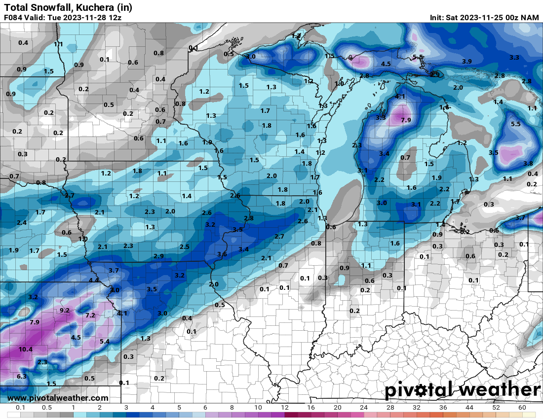
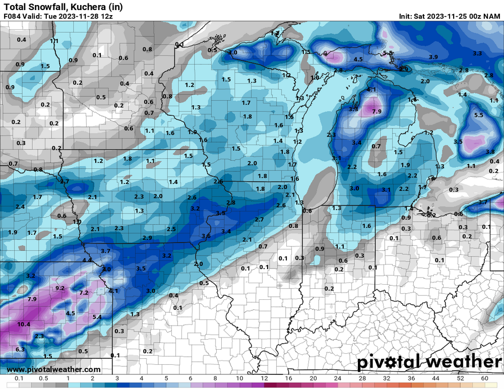
DTX (summary = gonna stack some more tenths) Shortwave tracking through the Dakotas this afternoon and slippinginto central Indiana by 12z Tuesday. Question is will this systemstill be strong enough and far enough north to support precipitationslipping north across the southern Michigan border. Based on thebulk of the hires solutions, and seeing 850-700 MB omega/forcing,the answers appears to be yes for areas along and south of I-94,with less confidence as one heads north. Mean temperature in the 850-700 MB layer looks to be -10 C. 12z NAM still maintains a closedsurface low/low level circulation through 18z Tuesday, which shouldbe good enough with 925 MB temps of -2 to -3 C. Any layer abovefreezing is right at or just above the surface, so snow is expectedto accumulate, especially after we drop into the upper 20s/near 30degrees tonight. Accumulation around half an inch along and south ofI-94 appears likely, and will then taper off pops quickly as oneheads north.
-
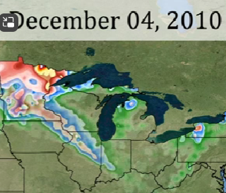
I wasn't even aware back then, but have seen this and thought "wow, that was kind of an odd system"
-
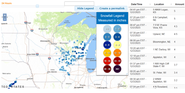
KS and WISCO putting up some numbers the last 24 hrs:
-
Haha, yep. Really, it ripped but it was after dark, I barely saw it twice out my window and here all 0.9" fell in about 30 minutes. By the time I realized it was "happening" it pretty much was just enough time to make that post and it was over. Then I really got the bigger shaft with this year's version. But, I will acknowledge that not ALL has been bad since moving here. I give 3-3-23 very high marks. Very hard-hitting and impressive storm with some ++SN.
-

Winter 2023/24 Medium/Long Range Discussion
RogueWaves replied to Chicago Storm's topic in Lakes/Ohio Valley
For WV? -
I would prefer the word "intense" which it indeed was just like the recent Squall Warned event. Mostly jabbing at him because I only got half his total. Even less this year. Stacking tenths will always have a lame feel.
-
This is heavy? And yes, I agree, it was exactly like what repeated this 11-27 as your area got a direct hit and I got half here (0.9), lol

-
About half an inch of RN here so far. Super dreary late autumn day.
-
First real snow threat wasn't until 12/23 last winter over here. Followed by another month of boring crap.
-
I scene what you did there!
-
Could we have a dry winter, and still have a decent amount of snow?
-
Not a wet look - anywhere. And tomorrow's event will be a day late to help November.
-
Hoping the MJO visit to the warmer phase(s) is not a prolonged event.
-
I was hoping to score the streamer to really make the event an over-performer. But hey, no complaints on verifying an 84 hr NAM run, lol
-
Congrats seems you have a magnet going again for these potent streamers.
-
I saw Wyandotte in the Squall Warning. How was it for you? mostly S of me, but the 0.5" took me to 2.1" for the 2-part event.
-
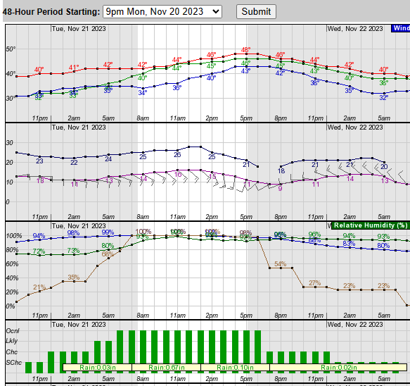
Been on/off pouring here since noon. Despite the steady 33F most everything has a layer of white. What one more degree could've done, lol. Certainly impressed with a nice performance on a S wind, warmest hours of the day, and very little climo support for acuumulating snowfall when Thanksgiving comes earlier. Anyhow, beats what many east of me have going on like noted by@Stevo6899
-
Winter 2023-24 Longrange Discussion
RogueWaves replied to michsnowfreak's topic in Lakes/Ohio Valley
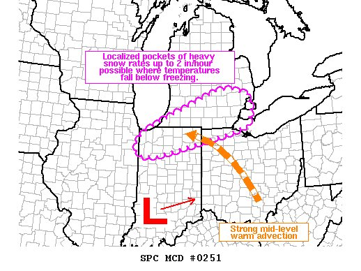
It was WAY off regarding the KS snowstorm, but at least we are getting some of that shown in SMI. I'll consider that a win being it's only Nov. -
I 2nd that. Who's ready for Lions football, turkey dinner, and measurable snowfall to round out the holiday weekend? DTX:
-
Cold HP's have been plunging down just east of us so it's a matter of time until it is cold enough to make the storms dump on NY/New England. Nino hand writing on the wall.
-
11/8 was a significant system for much of SEMI but north of the 94 corridor unfortunately. Now we are about to get the 2nd sig system so while there has been a lot of pleasant sunny days, it hasn't been a total snoozefest. Hourly showing 0.82" at DTW. Hoping for an over-performer. Late morning looking quite raw with WC's in the 30s and ongoing SHRN.
-
Winter 2023-24 Longrange Discussion
RogueWaves replied to michsnowfreak's topic in Lakes/Ohio Valley
From my post on another forum Not sure 15-16 was the best example to use, but it just came to mind quickly. It wasn't as bad for some of us as say 97-98 which might be the most classic example. I was having basically this same discussion with a poster from NWI where they've had a very slow start and he had posted how NWS Green Bay said "yep it looks like Nino's in full effect already". As @michsnowfreaknoted, it's actually NOT acting very Nino-like aside from the freak Halloween clipper thingy. I like the current system. Basically the same S Stream track that treated DTW favorably last winter. We just need cold air. Temps were so marginal with every event last year. Maybe this gets colder JFM and acts more like a Nina. As long as it doesn't mimic 11-12 -
Winter 2023-24 Longrange Discussion
RogueWaves replied to michsnowfreak's topic in Lakes/Ohio Valley
Dec '14 incoming