andyhb
-
Posts
20,454 -
Joined
-
Last visited
Content Type
Profiles
Blogs
Forums
American Weather
Media Demo
Store
Gallery
Everything posted by andyhb
-
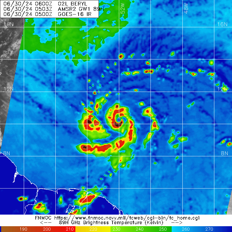
 Microwave passes continue to steadily improve. Nearly a closed eyewall now.
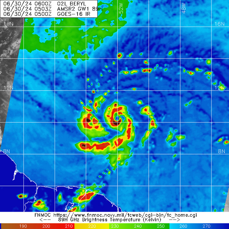
-
Thank you, good lord.
-
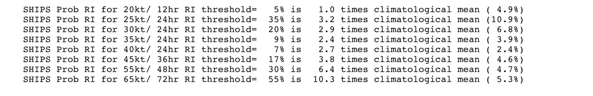
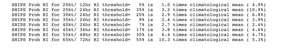
New SHIPS run continues with amazingly high probabilities of RI for this region this early in the season, especially the 65 kt/72 hour threshold. Can't be stressed enough that this part of the Atlantic and Caribbean is usually where TCs go to die this early in the year.
-
Sunday looks potentially impressive.
-
This cane season is really going to go to hell in a hand-basket, isn't it...
-
Also that very intense (unwarned for a time, yikes) tornado near Whitman Nebraska. That supercell in N OK was massive, good local chase.
-
Ryan has the best seat in the house.
-
Pretty great structure on the cell coming into Hartford too.
-
Tornado warning for Hartford.
-
They don't make them like this very often in these parts.
-
Look out for that cell coming into the Hartford metro. Rapidly strengthening.
-
Wonder if that cell gets a boost as it comes down into the Merrimack Valley, which would not be ideal for Manchester.
-
-
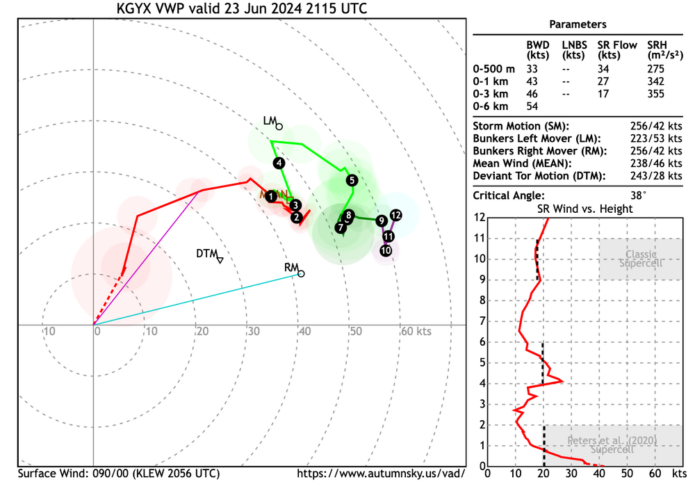
That's a dangerous, higher end wind profile at GYX with supercells to the west.
-
That Keene storm is really going off.
-
Cell in SW NH near Keene also looks decent.
-
Supercell near Poughkeepsie NY is worth keeping an eye on. A lot more isolated.
-
Lapse rates aside (and actually in this particular sounding they aren't that bad), this is impressive.
-
2024 Short/Medium Range Severe Weather Discussion
andyhb replied to Chicago Storm's topic in Lakes/Ohio Valley
That tornado near Marshall WI is nasty. -
See the problem with saying this all is that this is the highest tornado probs issued for this area of the country in quite some time. Given the lack of an EML which is a nearly universal indicator for higher end severe vs. run of the mill severe in this part of the country, I'm wondering why this was upped to a 10% so soon, tbh.
-
I still don't like reading "weak mid level lapse rates" for any threat in the Northeast.
-
At least 18 dead from last night, the situation in N AR sounds particularly bad.
-
At least 10 dead now (7 in N TX, 2 in Mayes Co. OK, and 1 in Benton Co. AR) from last night's severe weather.
-
Another large tornado down west of Decatur AR.
-
Models playing catchup on moisture this morning/early afternoon, including basically all of the 12z CAMs.