LVblizzard
-
Posts
4,968 -
Joined
-
Last visited
Content Type
Profiles
Blogs
Forums
American Weather
Media Demo
Store
Gallery
Everything posted by LVblizzard
-
Steady light snow. Started sticking immediately. Got a dusting so far, hoping for at least an inch when I wake up later this morning.
-
Just started 15 minutes southwest of you.
-
0z mesos generally agree on a region-wide C-1” with lollies to 2”. Unfortunately most of it looks to fall while we’re all sleeping.
-
I will take my inch and be happy. Really would like a big one this winter though. Especially since I was out of town for the storm with the rogue Lehigh Valley death band last year.
-
Our weekend threat is pretty much dead. Glad I never hyped it up on my page like so many of them did. C-2” still seems likely at least.
-
Watertown, NY would be a good place for him.
-
All 12z models except the UKMET and Canadian have a 1-3” or 2-4” event on Saturday. Big storm is still on the table but not really looking likely.
-
It’ll be close but the northern stream is lacking too much. Still should get a light-moderate event out of it. Edit: never mind, it got kicked out before it even reached 40N. Well then.
-
1/6 snowstorm - nuisance event or something bigger?
LVblizzard replied to LVblizzard's topic in Philadelphia Region
I don’t think any of the short range models had the wraparound snow up to the Lehigh Valley. Yet we’re getting a little bit. It’s really light and not accumulating. Still nice to have snow falling to set the mood. -
It was getting ready to head east in the next few frames. Our problem even if we get a strong storm is that s/w coming into the plains that acts as a kicker. So we couldn’t get a storm that stalls and loops near the benchmark like a lot of the classic ones do.
-
Snow gets down to Atlanta. But you’re close. It does look a hell of a lot better than 0z at least. Still whiffs everyone north of the M-D line but it’s closer.
-
1/6 snowstorm - nuisance event or something bigger?
LVblizzard replied to LVblizzard's topic in Philadelphia Region
Interesting how the snow went more north than expected (seeing reports of flakes north of Danbury, CT) but the heavy snow just did not want to reach SE PA at all. I can’t find a single report of over 2 inches in the entire Philly metro area. -
I wish I could buy the GFS but I just don’t. It’s possible but we need everything to come together perfectly. While there’s a chance it’s not a very good one.
-
1/6 snowstorm - nuisance event or something bigger?
LVblizzard replied to LVblizzard's topic in Philadelphia Region
Steady light snow in Allentown. All surfaces covered. -
1/6 snowstorm - nuisance event or something bigger?
LVblizzard replied to LVblizzard's topic in Philadelphia Region
This thread is awfully dead for a snow event that will begin in about 5-6 hours. We may not be getting the big amounts like DC, but it’ll still be decent for many of us. -
We need this thing to phase and deepen as early as possible with the kicker right on its heels. A more N-S ridge axis in the west would help too. Otherwise it grazes us and crushes the DMV area again.
-
1/6 snowstorm - nuisance event or something bigger?
LVblizzard replied to LVblizzard's topic in Philadelphia Region
Right now the northern extent of precip is roughly from Muncie, IN to Dayton, OH to Parkersburg, WV looking at mPING reports. Closer to the HRRR than the NAM. -
1/6 snowstorm - nuisance event or something bigger?
LVblizzard replied to LVblizzard's topic in Philadelphia Region
Northern extent of precip ends up being similar but it’s quite a bit drier. While the LV/Poconos aren’t too different from 6z it cuts totals in half south of the turnpike. -
The Euro shows a MECS at day 7 and no one here is acknowledging it?
-
GFS takes away next weekend’s storm. Euro brings it back. Another week of tracking ahead…
-
1/6 snowstorm - nuisance event or something bigger?
LVblizzard replied to LVblizzard's topic in Philadelphia Region
Euro came north with the heavy stuff but for those of us on the northern fringes it was unchanged from 18z. -
1/6 snowstorm - nuisance event or something bigger?
LVblizzard replied to LVblizzard's topic in Philadelphia Region
My rough thoughts right now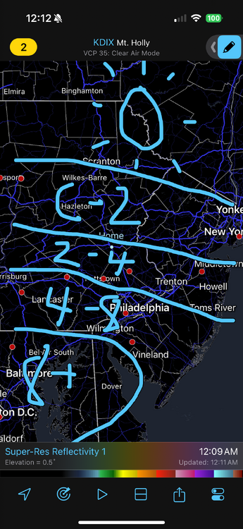
-
Snowfall NYC subforum Jan 6 and OBS if needed
LVblizzard replied to wdrag's topic in New York City Metro
RGEM* the global version doesn’t come out for another 45 minutes. -
1/6 snowstorm - nuisance event or something bigger?
LVblizzard replied to LVblizzard's topic in Philadelphia Region
RGEM is still ridiculously south. I do remember it being the last model to come around in Jan. 2016 if that means anything… -
1/6 snowstorm - nuisance event or something bigger?
LVblizzard replied to LVblizzard's topic in Philadelphia Region
This map is essentially my current thoughts about how this will play out.