LVblizzard
-
Posts
4,960 -
Joined
-
Last visited
Content Type
Profiles
Blogs
Forums
American Weather
Media Demo
Store
Gallery
Everything posted by LVblizzard
-
Sunday disturbance is trending colder. Most 0z models get accumulating snow down to the Lehigh Valley before it changes over to rain.
-
0z NAM/HRRR showing C-1” for most of us north of Philly. Up to 2” where heavier and more persistent squalls hit.
-
Snow shower just rolled through Allentown. No accumulation. Hopefully we can wake up with at least a little bit of white on the ground tomorrow morning.
-
Getting the edge of that squall in western Lehigh County. Some flurries but not much else.
-
That lake effect storm is just nuts. Some models are showing it affecting the Bills game tomorrow night. Would love another snow game.
-
Cold and dry pattern coming up…the worst winter weather imaginable. Hopefully we can at least get a clipper or something before the pattern inevitably flips.
- 1,105 replies
-
- 2
-

-

-
- tropics
- heavy rainfall
- (and 5 more)
-
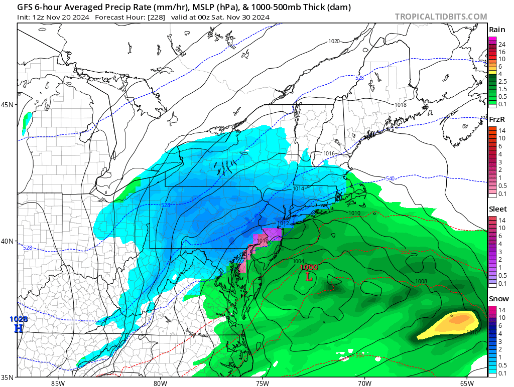
12z Canadian and ICON with a NW of I-95 special for turkey day. GFS suppresses it as that POS model often does in the medium range.
- 1,105 replies
-
- 3
-
-

-
- tropics
- heavy rainfall
- (and 5 more)
-
Rain mixing back in here. It was fun while it lasted.
-
Light snow in Allentown. Not sticking to anything though. At least not yet. Hopefully it picks up at some point.
-
Still a cold drizzle just west of Allentown. No mixing yet. When I wake up (probably between 8-9 am) I expect to see it snowing.
-
Already some snow reports in the Poconos on mPING. Here in Allentown it’s 42 and drizzling. Feels very raw outside.
-
Did some late night grocery shopping and brought the groceries inside, just a few minutes later it started to pour. I JUST made it. Phew.
-
First call… Philly: T Reading: C-1” Allentown: C-1” Hazleton: 2-4” Mt. Pocono: 3-6”
- 1,105 replies
-
- 1
-
-
- tropics
- heavy rainfall
- (and 5 more)
-
Still a signal for something around Thanksgiving weekend.

-
NAM has backed off significantly for NE PA but still gets snow down to the LV and Philly burbs. Probably wouldn’t accumulate since most of it comes during the day on Friday. We’ll see if the rest of the 12z suite agrees.
-
0z runs so far are looking very good for measurable snow down to the Lehigh Valley. BL temps will be warm but if we get heavy rates and the snow falls before sunrise on Friday, we could get a coating to an inch or two.
-
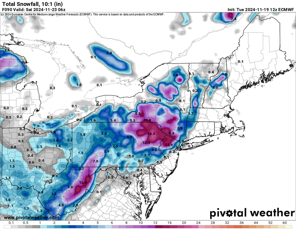
Euro just went full weenie for NE PA! Gets the Lehigh Valley in on the fun too.
-
In Philly? Yeah it’s not happening. But I do think the Lehigh Valley sees flakes and the Poconos get some accumulation.
-
Euro joins the party. Almost gets snow to Philly too.
-
12z GFS/CMC both have measurable snow down to the Lehigh Valley on Friday.
-
It’s raining in Allentown! Looks like it’ll be slightly more than a trace too. We’ll take what we can get.
-
Still no weenie snow maps though at least we have Pivotal as a free source for those.
- 1,105 replies
-
- 1
-
-
- tropics
- heavy rainfall
- (and 5 more)
-
I'm interested in that ULL swinging through in about a week. I think there's a decent chance some of us see our first flakes of the season.
-
Another large brush fire in Berks County. This one is fairly close to Reading and some homes are being evacuated.
- 1,105 replies
-
- 2
-
-

-
- tropics
- heavy rainfall
- (and 5 more)
-
This is disgusting. It’s November FFS. At least hoodie weather returns this weekend, and hopefully stays.