LVblizzard
-
Posts
4,900 -
Joined
-
Last visited
Content Type
Profiles
Blogs
Forums
American Weather
Media Demo
Store
Gallery
Everything posted by LVblizzard
-
1/6 snowstorm - nuisance event or something bigger?
LVblizzard replied to LVblizzard's topic in Philadelphia Region
Northern extent of precip ends up being similar but it’s quite a bit drier. While the LV/Poconos aren’t too different from 6z it cuts totals in half south of the turnpike. -
The Euro shows a MECS at day 7 and no one here is acknowledging it?
-
GFS takes away next weekend’s storm. Euro brings it back. Another week of tracking ahead…
-
1/6 snowstorm - nuisance event or something bigger?
LVblizzard replied to LVblizzard's topic in Philadelphia Region
Euro came north with the heavy stuff but for those of us on the northern fringes it was unchanged from 18z. -
1/6 snowstorm - nuisance event or something bigger?
LVblizzard replied to LVblizzard's topic in Philadelphia Region
My rough thoughts right now
-
Snowfall NYC subforum Jan 6 and OBS if needed
LVblizzard replied to wdrag's topic in New York City Metro
RGEM* the global version doesn’t come out for another 45 minutes. -
1/6 snowstorm - nuisance event or something bigger?
LVblizzard replied to LVblizzard's topic in Philadelphia Region
RGEM is still ridiculously south. I do remember it being the last model to come around in Jan. 2016 if that means anything… -
1/6 snowstorm - nuisance event or something bigger?
LVblizzard replied to LVblizzard's topic in Philadelphia Region
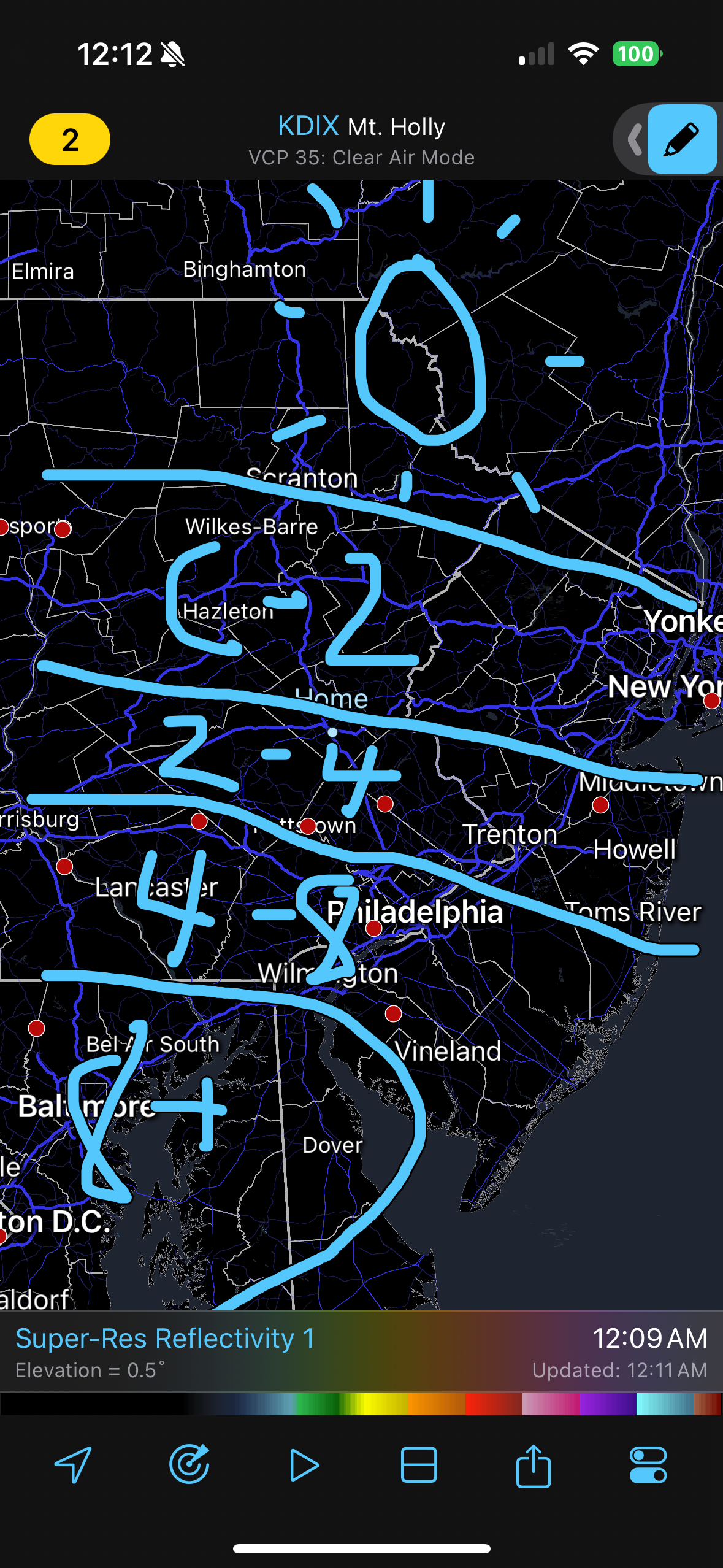
This map is essentially my current thoughts about how this will play out. -
1/6 snowstorm - nuisance event or something bigger?
LVblizzard replied to LVblizzard's topic in Philadelphia Region
Small tick south on both NAMs. -
1/6 snowstorm - nuisance event or something bigger?
LVblizzard replied to LVblizzard's topic in Philadelphia Region
Euro north a little as well. This is what I was expecting to happen since models usually overdo confluence. Now let’s see how far north we can go. -
1/6 snowstorm - nuisance event or something bigger?
LVblizzard replied to LVblizzard's topic in Philadelphia Region
21z RAP gets warning level snow almost to the Lehigh Valley. Not saying it’s right but it’s certainly interesting. Really looking forward to tonight’s 0z suite. -
1/6 snowstorm - nuisance event or something bigger?
LVblizzard replied to LVblizzard's topic in Philadelphia Region
I generally like to do that but the RGEM is a short range model despite not being super hi-res. So I feel like I can’t completely toss it like I am with the UKMET. -
1/6 snowstorm - nuisance event or something bigger?
LVblizzard replied to LVblizzard's topic in Philadelphia Region
Meanwhile the RGEM ticks south and screws over everyone north of the turnpike. I genuinely have no idea what to think at this point. -
1/6 snowstorm - nuisance event or something bigger?
LVblizzard replied to LVblizzard's topic in Philadelphia Region
NAM is essentially unchanged from 12z at the surface. 3km NAM, however, has jumped north, bringing warning level snow to Philly, -
1/6 snowstorm - nuisance event or something bigger?
LVblizzard replied to LVblizzard's topic in Philadelphia Region
Still snowing at this frame. We’d all be happy with this.
-
1/6 snowstorm - nuisance event or something bigger?
LVblizzard replied to LVblizzard's topic in Philadelphia Region
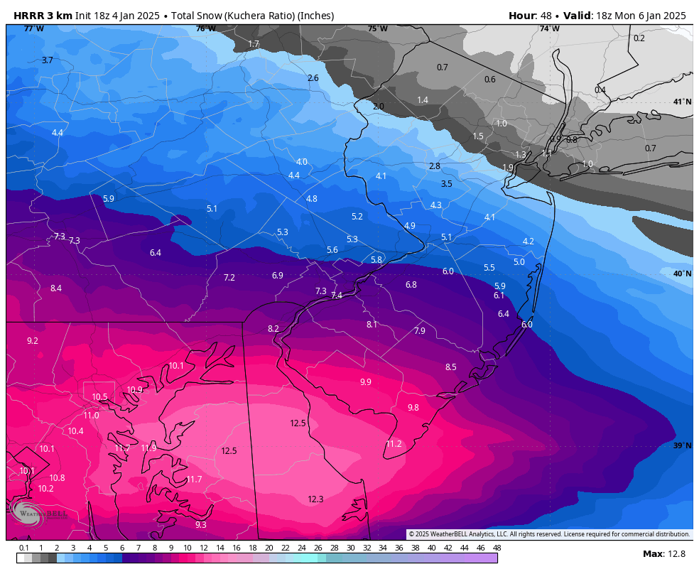
18z HRRR looks decent for us. Moderate to heavy snow up to the Poconos on Monday morning. -
1/6 snowstorm - nuisance event or something bigger?
LVblizzard replied to LVblizzard's topic in Philadelphia Region
Call me crazy but I still think the Lehigh Valley gets an advisory level event while warning level snow approaches Philly. I’ve seen these types of storms come 50 miles north in the last day or two too many times before. It feels like a matter of when it’ll happen, not if. -
1/6 snowstorm - nuisance event or something bigger?
LVblizzard replied to LVblizzard's topic in Philadelphia Region
No surprises on the Euro. It holds. -
SREF mean went a little north again. Sign of things to come for the 0z suite?
-
January 3, 2025 Light Snow Event Observations
LVblizzard replied to ChescoWx's topic in Philadelphia Region
Dusting on the grass in Allentown. Steady snow has stopped but some flurries remain. -
1/6 snowstorm - nuisance event or something bigger?
LVblizzard replied to LVblizzard's topic in Philadelphia Region
Ends up being a little better but the MA forum still wins. -
Looks like a…uh, never mind.
-
1/6 snowstorm - nuisance event or something bigger?
LVblizzard replied to LVblizzard's topic in Philadelphia Region
Not sure if we’re about to fully get NAM’d or not but this run should be better than 12z. -
January 3, 2025 Light Snow Event Observations
LVblizzard replied to ChescoWx's topic in Philadelphia Region
This is the kind of event where I REALLY wish we had a radar near I-81 in the coal region. -
1/6 snowstorm - nuisance event or something bigger?
LVblizzard replied to LVblizzard's topic in Philadelphia Region
There’s also some confluence we have to deal with in the upper Midwest. Although that could be related to that lobe over Maine.