nwohweather
-
Posts
3,780 -
Joined
-
Last visited
Content Type
Profiles
Blogs
Forums
American Weather
Media Demo
Store
Gallery
Everything posted by nwohweather
-
I’m watching very closely
-
You're not wrong. Awesome winds on the backside of that thing as it strengthened, you can also see up top the changing of the winds as well
-
Agreed, it feels so much better on the skin
-
Jealous of everyone hitting below 60 this morning, unfortunately I'm too close to the ocean for that yet
-
I was going to say it was like an MCV with a ton of couplets rotating around it. Really an odd feature, I’m sure the warm lake added to that
-
Hell of a feature spinning over Lake Michigan. Hard to explain what kind of feature it even is
-

2022 Short/Medium Range Severe Weather Discussion
nwohweather replied to Chicago Storm's topic in Lakes/Ohio Valley
It’s worth the debate. That line cooked for a long time and even caused a fatality around Toledo -
2022 Short/Medium Range Severe Weather Discussion
nwohweather replied to Chicago Storm's topic in Lakes/Ohio Valley
With that line continuing on from Illinois to New York does it technically obtain a derecho classification? It had two extreme wind reports and meets the 250 mile requirement -
2022 Short/Medium Range Severe Weather Discussion
nwohweather replied to Chicago Storm's topic in Lakes/Ohio Valley
Back in NW Ohio eh? -
2022 Short/Medium Range Severe Weather Discussion
nwohweather replied to Chicago Storm's topic in Lakes/Ohio Valley
Damn, there is some serious instability to the east of that line. Shear could be a bit better but this thing should hum through IN/MI/OH this evening -
Mid to Long Range Discussion ~ 2022
nwohweather replied to buckeyefan1's topic in Southeastern States
I just want sunshine at this point -
Mid to Long Range Discussion ~ 2022
nwohweather replied to buckeyefan1's topic in Southeastern States
Well said! I moved here at the beginning of 2020 and have not seen this overcast of a stretch since winters in Ohio. With this much troughiness in the US it's going to shut down the tropics with system after system -
Peak weather. Up here for the week, loving it after golfing this weekend in 92°/80° weather
-
I’ve seen 6” in a day since moving to Charleston and I cannot believe what a full foot would look like. Basically like being under a water park bucket
-
Not often you see the catastrophic flooding tag on a warning
-
Summer 2022 Medium/Long Range Discussion
nwohweather replied to Chicago Storm's topic in Lakes/Ohio Valley
Ahh that’s a good point. Hell I’d even see hard gradients when I lived in NW Ohio. There’d be April days where you’d see temps of 55° in Toledo with an east wind but 75° around Findlay/Lima. It’s truly amazing how different places like Toledo/Cleveland are compared to even Columbus in climate -
Summer 2022 Medium/Long Range Discussion
nwohweather replied to Chicago Storm's topic in Lakes/Ohio Valley
If I’m not mistaken that was followed by an active Fall severe weather season as well. I remember 2018 being a pretty hot year as Toledo reached 90° 44 times which is impressive as hell considering it’s proximity to the lake. What I couldn’t imagine up there would be the heat waves during the Dust Bowl. I’d love to see what those surface maps looked like with the Great Plains essentially being Phoenix East. I do say all of this by the way while sitting at my pool in Charleston with current conditions of 91°/77° so I’m definitely jealous of your June-August climo -
Now you know what it feels like here from June 1-September 15
-
Glad this took off like it did. Was cool to watch for sure, the banding and swirl were obvious on both radar and eye sight yesterday evening in Charleston
-
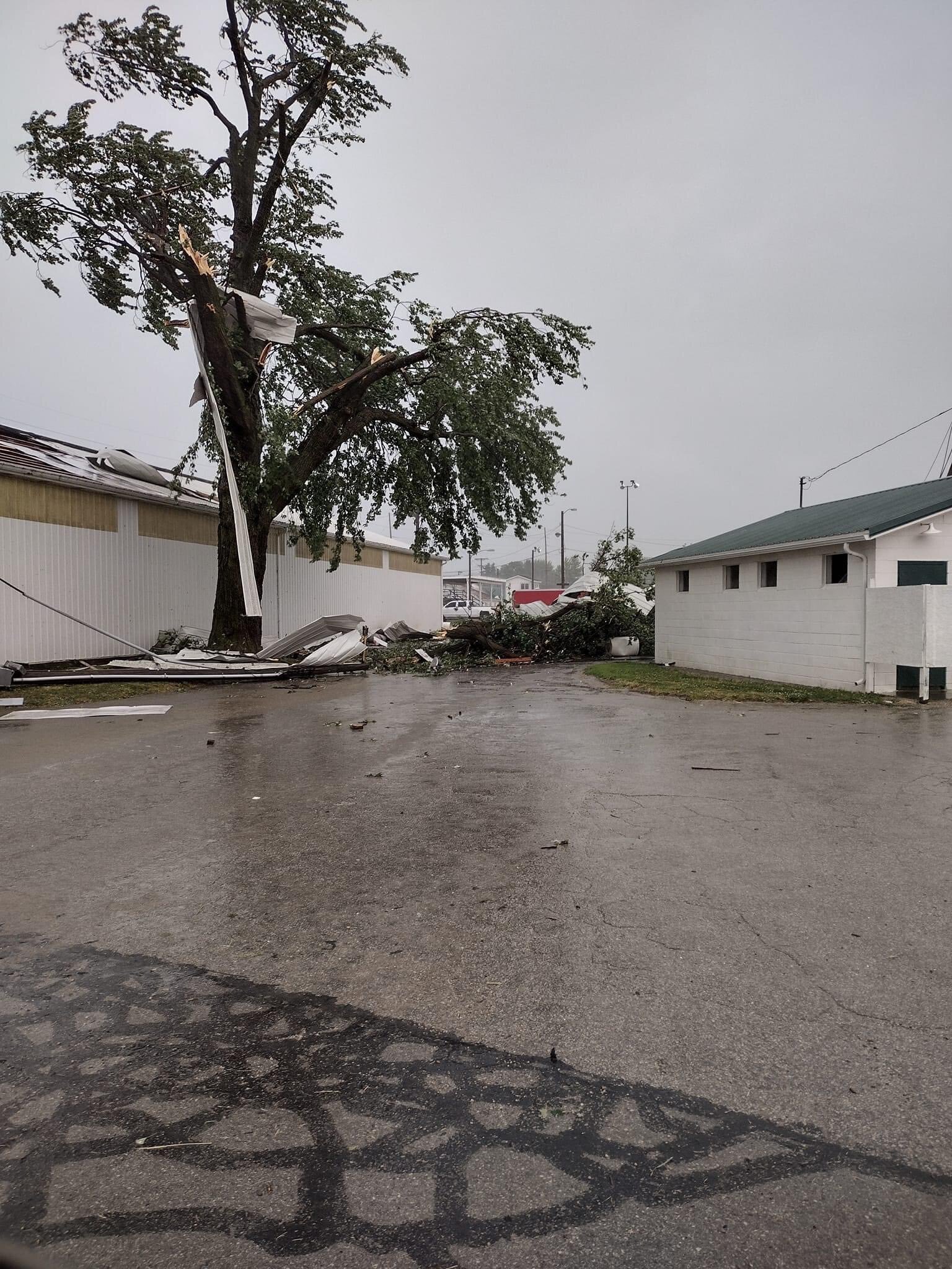
Apparently significant wind damage just occurred half hour ago in Fremont OH just west of Sandusky. Getting reports of lots of damage across the city

-
It’s gonna be a rough evening across Charleston. Consistent 25-40 mph winds with heavy rain in that band approaching Seabrook
-
Tightened up a bit with winds 30-40 mph in that band above the center
-
The banding and humidity is so damn tropical. Currently 77 with 100% humidity
-
2022 Atlantic Hurricane Season Tracking Thread
nwohweather replied to WxWatcher007's topic in Mid Atlantic
It's just so well defined and convection appears to be strengthening over the Gulf Stream -
2022 Atlantic Hurricane season
nwohweather replied to StormchaserChuck!'s topic in Tropical Headquarters
Honestly though how is this not a system? Defined center, has its own moisture transport and has it's strongest winds in the NE quadrant of the "eye". If you get some sustained 40-45 that'd be enough