LongBeachSurfFreak
-
Posts
9,330 -
Joined
-
Last visited
Content Type
Profiles
Blogs
Forums
American Weather
Media Demo
Store
Gallery
Everything posted by LongBeachSurfFreak
-
I have feeling we take a real hit this summer. Gloria in 85 was the last real hurricane to hit Long Island. We are more then due
-
Would have been a nice snow storm mid winter. Nothing historic but a solid warning event.
-
You wouldn’t want it to snow? Lots of elevation there, it’s a great late season snow spot
-
Frightening preview of things to come. some interesting wind obs last night on buoy 44025 gusting to 52 knots. I wonder what caused this wind burst. It was way out ahead of the front. 03 31 11:00 pm - 27.2 38.9 - - - - 29.51 - - 43.7 - - - - 03 31 10:50 pm - 29.1 36.9 12.1 9 6.5 S 29.51 - - 43.9 - - - - 03 31 10:40 pm - 29.1 48.6 - - - - 29.52 - - 43.9 - - - - 03 31 10:30 pm - 31.1 52.4 - - - - 29.51 - - 43.9 - - - - 03 31 10:20 pm - 29.1 44.7 - - - - 29.51 -
-
It’s way cleaner then even the 80s. Growing up at Jones Beach, we used to call the water Jones Beach brown. You would often come out of the water with tar on your skin. now, clean water days are the norm, and I can’t remember the last time we had tar
-
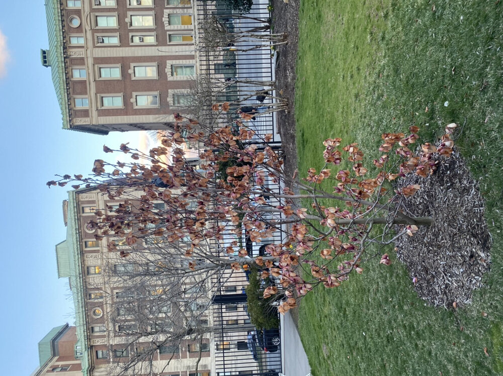
Since I work as a horticulturalist, extreme late fall and early spring blocking events and subsequent Arctic outbreaks are killer.
-
Can’t get any worse then this morning. Dead flowers everywhere. And not even a dusting. I did notice driving in this morning that the cross island was buried in salt just north of the lie. I’m talking insane amounts of salt. That’s great for the environment…..
-
Yep. It’s gruesome on my campus. I can take loosing the early season flowers, but some mid spring stuff was starting to pop that may be ruined too. I drove home from Vermont yesterday evening through some incredible snow squalls. Some areas had an inch or two then a few miles then nothing, this went on for 100 miles from Albany to just north of 84. I would love to see at least a dusting out of this Arctic mess
-
Unfortunately the magnolia flowers are toast. Some hardier early bulbs like daffodils can handle cold better. But tree based flowers will just burn and fall off. We have managed impressive Arctic outbreaks in both very early and very late season the last few years but mid winter has been more difficult.
-
Yup. I have tons of early flowers in bloom on campus. Most, like daffodils will handle it without being trashed. But our magnolia will loose it’s blooms. I’ll take the loss if we can at least pull a snow event and not waste the cold
-
Had a great day yesterday at Stratton. What you expect for a warm April day. Wait it’s March. I can’t see the southern resorts having much more then a few trails open next weekend. Today’s things were getting dicey with water bars everywhere, mud and dirt sections and little natural left except deep shade areas. The pic is at the summit of ursa, not what you want to see

-
Sounds about right… meanwhile in Vermont
-
Agreed who would want to live in the flat portion of far northern Maine unless your a logger. Sw Maine mountains average similar snow with far superior scenery. And you aren’t an additional several hour drive from civilization.
-
Allot of it has to do with geography. The Delmarva is open to oceanic flow on a NE wind during most coastal storms limiting snow potential.
-
 That’s a static number. The number tends to be larger this time of year as the land starts to heat from increased sun angle. It’s part of why we say late season events are elevation dependent.
 -
That last band disappointed on the uws. Only a light dusting. There is more sleet and snow from earlier today then recently. In some ways this event reminds me of 2001. Just didn’t have its act together in time to produce a solid precip shield.
-
Please talk about the current event! radar says moderate snow ground truth says…… have some flurries allot of evaporation on that Nw flow
-
I think we all get a coating with this band. It’s got some dynamics. Timing is better with lower sun angle and temps are much colder
-
The sleet is actually problematic for roads as it lays down a coating that snow then can stick on. This one is going to surprise allot of people. everything now coated on the uws
-
Wow, instant coating on the uws! Moderate snow/pellets mix. We are going 3”+ here
-
I like where I am for this one. Just south of the gwb a block from the Hudson. I have a feeling there is a hour or two period where it rips 1-2”/hr and that’s where we get 3”. This one is going to surprise allot people in this part of the city. March storms tend tI be very dynamic and banding more intense. At home on the island it’s a coating
-
I’m sure you realize this so I’m just saying it general, but the heaviest snow will not coincide with the strongest winds. The strong Nw winds are a drier wind and snow will be tapering off at that time
-
This is so damn spot on. I almost have nothing else to say. also factor in ground temps will be extremely warm from today. So snow will have a real hard time sticking. I think by the time the 20s hit the coast your looking at light snow. I do think everyone sees a paste of white, as it will not be melting with temps dropping snow removal and salting will be needed everywhere
-
Would love to be on the coast of Labrador for that. Hurricane force sustained winds and feet of snow. I think the precip ends just too late for the City east before the cold arrives.
-
Ok good. You can clearly see in my pic. (Not sure why they are always sideways) that there was enough to push around with the little plow. Clearly not a trace