-
Posts
9,277 -
Joined
-
Last visited
Content Type
Profiles
Blogs
Forums
American Weather
Media Demo
Store
Gallery
Everything posted by LongBeachSurfFreak
-
Especially this year with the water being colder then normal do to all the offshore flow and upwelling. This pattern will not do much to warm the water either. May be a chilly start to the beach season once the flow switches back to consistently onshore.
-
Top of the line spring day today. Just finished a 5 mile hike. Living on the south shore really makes you appreciate any real spring weather as we often skip right to summer…
-
Just had a pretty strong gust that threw around some stuff in my backyard. I’d say close to what we had yesterday.
-
Convection produced and more in line with a STW instead of a widespread multi hour wind event. That’s what I think the NWS was going for.
-

2025 Atlantic Hurricane Season
LongBeachSurfFreak replied to BarryStantonGBP's topic in Tropical Headquarters
Solid forecast. I think we see a Felix/dean style Caribbean cruiser this year. The OHC is off the charts and due for some heat reduction through hurricane induced upwelling. -
Absolutely the definition of misery mist currently on the south shore. High 30s gusty north wind and sheet drizzle. It almost (looks) like light snow.
-

2025 Atlantic Hurricane Season
LongBeachSurfFreak replied to BarryStantonGBP's topic in Tropical Headquarters
Could be a good setup for US landfalls as TW coming off Africa wait longer to develope. Less chance for early recurvature. The NE Caribbean is especially really overdue for another Irma type powerhouse. -
Some nice high spots that are a doable commute to NYC.
-
Allot of the time the guys doing the snow removal do not have a deep understanding of the weather. Just wasting salt and damaging the environment in this case. Any snow left on the road after plowing will melt in quickly melt in April as insulation makes it right through the clouds.
-
Nice, thanks for posting that. I was estimating based on surface temps and conversion 1 degree per 200 feet.
-
The radar looks like it should be snowing 2” an hour right now. It has that exact texture. Because at beam hight it’s all snow. Snow levels probably currently between 1500-2000’ feet based on surface temps. That terrace I was talking about at 1500’ will be covered in several inches in the morning.
-
Pouring right now in SW Nassua, I guess this system does have some decent dynamics. Let’s see how much we cool the column overnight.
-
No clue. I was 1. Would have to see the historical data especially low placement and strength.
-
Yeah this late in the season it’s all about rates. Someone near the coast could get a coating. Most likely place would be highest elevations of north shore of the island somewhere like north hills at 300’. But it could be anywhere if it really dumps. It could just as easily be no one.
-
I mean they have tuned mass dampeners, which is a big weight at the top of the building that counters the sway. But yeah, if the winds cranking it can only do so much. None of those super talls were there yet for sandy. Other then the one under construction which is significantly shorter at 1,000’ and look what happened there. I would have to imagine in a sandy redux you would not want to be near the top of those buildings.
-
Real spring weather is amazing. Having lived in Maryland for 4 years for college I miss those endless April days of sunny and 70s with low dews. Such a rarity on the south shore of Long Island. By the time we start seeing consistent 70s in Late May/June it’s already accompanied with and sea breeze and higher dews.
-
Yes it’s higher. 1550’ for the Nordstrom tower vs 1396’ for 432 Park Ave. Both fully residential and have higher roof heights then 1 World Trade Center. While NYC no longer has the tallest buildings in the world it still has the highest residential buildings. I think part of the reason they are having trouble selling that pent house is, it’s so high it’s often in the clouds.
-
That was a really powerful nor’easter for so late in the season. Had some sleet mix in at times on the north shore of Nassua. Air show at jones beach completely canceled. Pretty much a worst case scenario for MDW.
-
Cool 150,000,000$ that’s the asking price. It’s the highest residence in the world. It’s been sitting on the market for a while though last I heard.
-
There is a pent house on top of the Nordstrom tower that has a big patio at like 1500’. That patio is the ultimate weather weenies dream. It’s so high you look over the Empire State Building. Probably get a few inches at 1500’ in this setup.
-
Southern hemisphere screamer! That’s a pretty epic model run, I think 865 is the lowest pressure I have ever seen modeled.
-
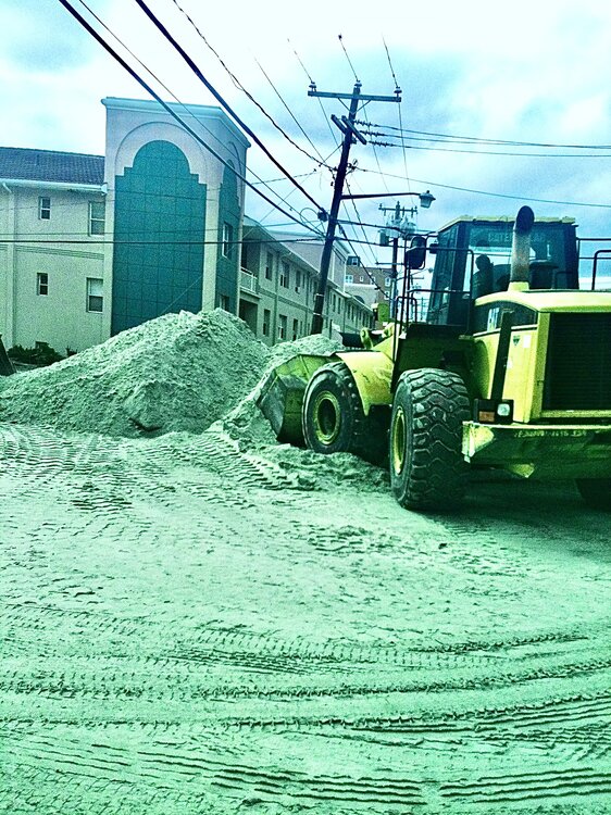
92 moved more sand then any event in my lifetime. Sandy, didn’t move sand laterally so much as pushed it inland. Pic from my first apartment at Monroe Beach after sandy.
-
This isn’t easy for me to describe in words. So bassically the prevailing flow of sand on the south shore, called the lateral drift goes from east to west. As the bluffs erode in Montauk they renurish the beaches to the west with new sand. You can actually see the sand particle size decrease as you head west. With Long Beach and Rockaway having much finer sand then the Hamptons. Under natural conditions the beaches erode and are replenished seasonally. Since humans added things like jettys to keep inlets open and groins to trap sand we have disrupted the flow of sand. Thats why there is a need for intervention. If you look at a place like west end 2 and jones beach, the large jetty protecting jones inlet acts as a block to sand movement. That area has been growing year after year. Further east at gilgo there is net erosion. So that sand that was added at gilgo ends up heading west and gets stopped by the jetty. All of this happens regardless of the local winds, seasonally. I’m sure the strong westerly winds did slow if not stop the lateral drift for a time. But any long period of easterly flow ramps it back up.
-
Could be some min/mid coastal flooding and beach erosion due to the fetch and duration. The ACOE did a major dredging of fire island inlet and dumped the sand at Gilgo where a new inlet is constantly trying to form. (There was one before it was filed for ocean parkway) Despite the fact that we have had such fast westerly flow the beach at jones beach is already about 50 yards bigger then last summer. Should grow even more this weekend.
-
Nice to see that storm track finally!! Not an especially deep so we would need strong high pressure interaction for a nor’easter.


