

Allsnow
-
Posts
23,585 -
Joined
-
Last visited
Content Type
Profiles
Blogs
Forums
American Weather
Media Demo
Store
Gallery
Posts posted by Allsnow
-
-
Next Friday will probably be ridiculously warm for early January

-
 1
1
-
 2
2
-
-
11 minutes ago, SnoSki14 said:
Next weekend could be record breaking. Today's Euro indicates 60s possible, insane 850mb anomalies.
LA might be colder than us.
Next weekend has a chance to be real nice before any rain. Friday through Sunday

-
 1
1
-
 1
1
-
-
18 minutes ago, bluewave said:
Even though the SE ridge didn’t show up In the means into early December, the cutter and hugger storm tracks would briefly kick it up. So in effect, we had a transient SE ridge for our storms. That’s how Albany had 27.9 inches of snow in December to only 2.5 in NYC.
Yep. That second storm in December with the transient 50/50 dug a bit to much out west and kicked up the ridge. Most of the area was between 32-34 with rain.
-
1
-
-
-
4 minutes ago, SnowGoose69 said:
Ultimately it’ll probably come down to the MJO from 1/20 or 1/25 onward. If it goes back through 4-5-6 this winter is done. If it stays quiet it could possibly be a big 6-8 week period
You can see substance developing in the warm phases on the roundy plots. Let’s hope that’s the case after we get out of p6. But it’s in the long range and convection is unpredictable

-
36 minutes ago, bluewave said:
If the new EPS is correct about the MJO continuing into at least phase 6, then the warmth will extend well into late January. It would probably take until early February to reach the colder phases if the MJO doesn’t weaken first.


It will probably get worst before it gets better. With no strat help we will be at the mercy of the mjo. It doesn’t look like this should linger in p5 (def a worry with the warm waters there) as the rmm plots have been correcting closer to the colder phases. Until then all we can do is enjoy the warmth coming.
hopefully the roundy plots are correct with this mjo getting into p7-p8 by the 20th. If not winter weather/cold will be in big trouble for February.

-
2
-
-
5 hours ago, Isotherm said:
I am uncertain whether I ever recall seeing such an expansive (or any) area of 32C coverage in that part of the world. These are 90 degree F water temperatures to the north of Australia. For such an anomaly in the deep tropics, it yields a significant impact on the energy budget as you know, and concordantly, it isn't surprising to see the modeled high amplitude in phases 4/5 of the MJO. This is akin to throwing gasoline on the proverbial fire. Ambient SST's of 32C/90F are very impressive. This will further serve to enhance the MJO in its unfavorable [from E US perspective] octants.
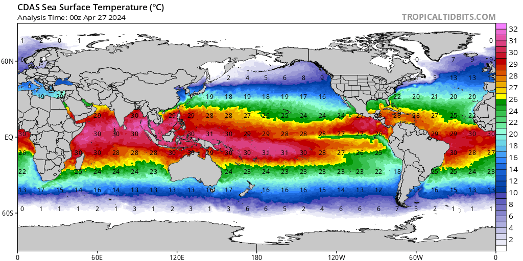
Good post by @bluewave regarding the warm waters by Australia. I tend to think it might want to linger in P5 because the mjo is convection and loves warm waters. One of the reasons why we spent most of December in P2 was the warm waters creating a standing wave.
I believe what happens with this mjo wave will hold the fate for what happens at the end of January into February. The roundy plots and vp maps have this entering p7 by the 20th.


@tombo82685 stated to me that the jma keeps this in p5 to the start of January and the CFS gets it into p8. Definitely the reason for their differences regarding the rest of this winter.
-
2
-
-
3 minutes ago, tombo82685 said:
Agreed, I would take that 6z euro map and cut it in half maybe more with accumulations if we are taking the model at face value here. While it’s cold enough to snow on it, how much of that truly will stick with surface temps in the 35-37 range? That just smells like white rain and Piss ooor ratios. Same thing happened to nyc back in early dec just couldn’t overcome poor BL despite decent precip. If things tick colder then I would start to buy into a better chance for accumulations in the city. North and west complete different story.
Yep. I sat at 34 the entire time with poor snow growth. This is taking a similar track with a similar airmass.
-
1
-
-
-
2 minutes ago, bluewave said:
The storm probably tracks near or maybe just south of Long Island with a change to snow at the end. Temps will be marginal for accumulations. But we could see something especially on the colder surfaces if it snows hard enough. Even a C-3 event would be nice before the eventual warm up around the 10th.
These Miller B’s tend to favor sne and Long Island. I would not be shocked to see little to nothing around the metro with 2-3 on the island.
-
6 minutes ago, Snow88 said:
You cant deny the trend though.
H5 looks really good
We just need the temps to cooperate
The problem for the coast is the fact the airmass is marginal at best and the primary low is to strong. It would be nice to see the primary weaken earlier.
-
2 minutes ago, Snow88 said:
6z euro still looks really nice.

-
5
-
-
1 minute ago, bluewave said:
That rapid SST increase north of Australia in MJO 5 may be why some models want to linger the forcing there.


-
2
-
-
Just now, EastonSN+ said:
Kind of what this shows unfortunately

It’s convection, so I wouldn’t put much stock in a rmm plot that far out. Most mjo plots don’t go out that far. The roundy has it in p7 by the 20th.
-
1
-
-
Just now, donsutherland1 said:
It does. Some MJO passages through the Maritime Continent (Phases 4 and 5) at very high amplitude have produced a bout of near-record to record warmth. So one or two days where the temperature spikes is certainly within the realm of possibility.
Next weekend temps couple be well into the 60’s

-
2
-
 1
1
-
-
Hopefully the mjo having amplitude in the warm phases can help trigger some hits on the PV.


-
1
-
-
Just wanted to make a quick post about the anomalous warmth heading our way in January. Some of the analogs are starting to point to January 2007 regarding the magnitude of the warmth.
I believe the reasons we have this potential is because of the strong PV and lack of a true El Niño. The following maps are the response we get in p4 and p5 of the mjo in a neutral ENSO.


The eps and GEFS are in perfect sink with these responses.


I can see temps in the urban corridor be well into the 60’s with this look. The storm track will be well west of our area into the Great Lakes.
Going Forward I see very little change towards the end of January. I believe if we want to save February we need to start seeing strat hits on the Pv and the mjo wave, currently in p4, make it into the colder phases. If we continue to see the wave weaken into cod we very well might have a clunker winter on our hands.
-
5
-
-
1 hour ago, EastonSN+ said:
Aweful.
.gif.2f50c34bc417c10306cc244f6042e9a4.gif)
.thumb.gif.b759bd89be3d117ea2bff266b5b7822b.gif)
.thumb.gif.b079ac24634eef533fcb917bd6228286.gif)
.thumb.gif.a58db39971a715190d394623000dce96.gif)
I would use caution with ripping and reading those rmm plots. @tombo82685 The GEFS forecast is complete garbage on that plot. Convection dosent go backwards like that. If you look at the vp200 maps you can see a standing wave over Australia. The rmm plots are focusing too much on the lead wave and then jump to the actual mjo wave over Australia. This will be in p8 between the 8th and 10th. The hot take this winter has become the awful rmm plots that chase convection everywhere. Stick with the vp200 maps or the euro forecast.


-
1
-
1
-
-
7 minutes ago, Ginx snewx said:
Hey bro think John Doug and Steve have a good grasp. Hope all is well in the fire service.
All is well Ginx, thank you. I think we are definitely on track for a nice 2nd half of winter. Typical niño climo warm 1st half, cold second half. The wildcard will be a possible SSW. I agree, the Nyc metro wx team definitely has some great talent.
-
38 minutes ago, HoarfrostHubb said:
Sweet! A post by Allsnow! Hope you are well
All is well! I wish you a happy and healthy new year.
-
1 hour ago, SnoSki14 said:
Fantasy but wow that's a disgusting 18z Gfs op run. Pure Pacific puke with a death vortex over Alaska and tepid -NAO.
Jan 1-10 torch?
Stop using a op model that is awful outside 7 days. It couldn’t be any different from it’s own ensembles.
-
1
-
-
34 minutes ago, Snow88 said:
Allsnow is trolling other forums with warmth
That's not over Europe lol
25 minutes ago, CoastalWx said:The MJO has been stalled near 135 E though. That hasn’t helped. It should progress more to the east with time.
I’m not sure where I’m trolling about warmth @Snow88. I’m getting tired of shoveling all of this potential you have been posting about, as we stare in the barrel of another cutter.
@CoastalWx I could not agree with you more regarding the next few weeks. The Kelvin wave slowed the mjo progression in p5. Unfortunately, convection is very hard to forecast. I would be careful about posting the RMM plots, the vp200 maps are more accurate imo. Either way you slice it, we should be in p6 by the end of the week. The pna should improve after the 4th, and the majority of the guidance agrees with this. @40/70 Benchmarkoutstanding seasonal outlook! We should have a killer 2nd half of winter.
@ORH_wxman I know we have not been on the same page the last few years. I can’t say I didn’t give you reason to feel the way you feel. My apologies for the immaturity I showed.
I don’t come to this forum anymore, but my best to sne for 2019. We should be tracking soon. A few more week and this downtime will be a distant nightmare.
-
2
-
-
Land of the misfit toys
-
Still pretty cloudy here and not the best of days


.gif.13a4e5eb732c3c9e9e9a4c9f2dd58b9b.gif)
.gif.eb87fc3aa9db279c8deb222196cce181.gif)
.gif.811d46a76d4548feb4578c1b20dbadfc.gif)

January 2020 General Discussions & Observations Thread
in New York City Metro
Posted
Yeah. The atmosphere was more Niña like and ENSO was Niño during 2019. We really never got a true nino response in that 8-1-2 pass during February. I definitely agree that the mjo wave could go 7-cod at the end of the month. We should improve the pattern to a more of a overrunning look later in the month. As you said in your outlook, the pac isn’t going to play ball this winter. The PDO killed any hope of that.
I still don’t see any strat help in the near future. Do you think it starts taking punches in February? The Scandinavian block developing might be a sign of a -nao coming in February.