

Allsnow
-
Posts
23,611 -
Joined
-
Last visited
Content Type
Profiles
Blogs
Forums
American Weather
Media Demo
Store
Gallery
Posts posted by Allsnow
-
-
23 minutes ago, weatherpruf said:
Depends on your location. Few of the storms outside of Jan 2016 were much to talk about in my region, relative to others. Only the last March 2018 storm delivered ( about 9 inches give or take ) and we did have the Easter Monday snow of 3-5 as a consolation prize, but other than that it has been near misses, subsidence, mixing issues, dry air, you name it.
Winners and losers in every storm. We haven’t had it bad in middlesex county since 2009. I’ll gladly take 4-8 over getting skunked completely
-
20 minutes ago, ORH_wxman said:
The folded-over EPO block links up with the building PNA ridge around 1/20-1/21 and the flow becomes extremely meridional, so I could definitely see there being support for a larger scale threat a day later or so. (1/22ish)
Obviously caveats apply as the look could change, but the reason the pattern has been pretty excited is because of how meridional it looks. That will keep the threats rolling in with a ton of cold over us.
Yep. The ridge off the west coast should keep things active and the cold/dry debbies at bay.
-
Just now, Brian5671 said:
early Jan 2018 storm was widespread I believe-that came at the end of a bitter cold 10 day outbreak-was all snow I think
Yes, but I believe that was a bit east of the classic benchmark track. Our last east coast blizzard from DCA to Bos was back in 2016.
-
 1
1
-
-
13 minutes ago, SchaumburgStormer said:
Just a little shift. Classic NAM.


It’s been a rough winter for the models. The euro and nam seem to be too amped in the short range.
-
28 minutes ago, bluewave said:
Like I said, mixing issues with KU benchmark storm tracks are not a problem. We had some mixing issues with the last March 2018 storm and still went 10-20 inches of snow. But these 1-3 or 2-4 front end thumps then sleet or rain have been a big disappointment since last winter. That’s what we get with storm tracks to our west that cut or hug. Hopefully, we return to a rapidly deepening benchmark storm track.
KU/benchmark tracks don’t grow on trees. We have been extremely lucky since 2009. Many on the coast have become spoiled With the amount of snow that have had. It’s no shock that we have regressed to the mean. The last area wide snowstorm was definitely 2016. We are obviously over due now.
-
1
-
-
8 minutes ago, bluewave said:
It wasn’t that long ago. We had plenty of benchmark storm tracks with double digit snowfall at the coast right through March 2018. Last winter we started with the cutter and hugger storm tracks where interior sections had the heaviest amounts.
Yeah, but that first March 2018 storm took a perfect track and still skunked the coast. We had some nice track last winter but no cold air around. With the pac improving I wouldn’t be shocked to see the track you are looking for. But to not expect mixing issues along the coast in any storm is unrealistic expectations.
Edit: not implying you have unrealistic expectations
-
11 minutes ago, bluewave said:
We’ll know the storm track has improved when we get an amped system with no P-Type issues. That’s what we have been waiting for. People at the coast will be happy when they get all snow from start to finish.
It’s probably been since 2016 since we have had that. Even with a perfect track, people on the coast should expect P-Type issues. How many storms can you recall that it’s snowing at High Point And Acy?
-
1 minute ago, Snow88 said:
Euro has a nice front end thump with the storm for next weekend along with a secondary further south.


-
1
-
 1
1
-
-
6 minutes ago, NEG NAO said:
YW - I am not forecasting anything - I believe you have to have an open mind in this situation and consider all the possibilities which in this case are many....I do belive in the shorter term we will have possibilities of snowstorms going forward but I didn't like that cutter look that has appeared on the 12Z GFS

Next weekend the pac is still reshuffling which is going to allow for another cutter. If we can place a nice high pressure beforehand we can get a front end thump. ( euro and gfs show this)It’s after the 18th that the pattern really improves. I wouldn’t rip and read the long range op gfs as it is going to look completely diff at 18z. I agree, you can’t have biases when it comes to weather. If the pattern going forward looked unfavorable I would be the first one the tell you.
-
4 minutes ago, NEG NAO said:
IMO I still think going into the COD then going towards 4/5 as some are showing as a real possibility - I also believe in patterns repeating themselves with still the possibility of being in the same warm phases in the middle of next month - not sold on going into phase 2 yet …
Those same plots had it looping back into cod after p4 a week ago. I wouldn’t bank a forecast on those long range rmm plots. Even as is, that plot shows some members going around the horn. Either way good luck with your forecast.
-
2
-
-
6am Sunday! Crazy

-
2
-
-
10 minutes ago, NEG NAO said:
what hard evidence do you have to support that theory ?
Mjo progression, the warm waters by the dateline, and the amplitude of the mjo wave. I also have support from the eps,GEFS, and Geps.
Other then ripping and reading the rmm plots, what hard evidence do you have?
-
3
-
-
And I get it, most of you won’t be convinced a colder/potentially snowier pattern is coming until your under a winter storm warning with a defo over head. I see no reason why a colder pattern won’t take over at the end of January into the first half of February. I would more then welcome a early start to spring if the mjo returns to the warm phases after a few snowstorms.
until then, enjoy the record warmth! Tomorrow is going to be beautiful
-
3
-
2
-
-
Just now, snowman19 said:
There wouldn’t be a worse scenario, if we go back into 4/5 in early-mid February, it’ll be time to start thinking about next winter
Looks like we will spend most of the first half of February in the colder phases. Paul roundy site has us in p2 around mid February. After that it will depend on any Strat help or other factors. The euro has a bias on going cod at the end of those rmm plots. This will not be going cod p4/5.
-
1
-
1
-
-
36 minutes ago, Allsnow said:
The 17/18 threat has always had that overrunning look to it. The storm will cut west as the pac is still reshuffling, we just need to have a cold High pressure in front of it.
This is what I am talking about when I post overrunning. You have the first cutter acting as a transient 50/50, a cold high 1032, and moisture overrunning the cold air. This is definitely the first legit threat for our area next weekend.

-
3
-
-
The 17/18 threat has always had that overrunning look to it. The storm will cut west as the pac is still reshuffling, we just need to have a cold High pressure in front of it.
-
1
-
-
6 minutes ago, weatherpruf said:
Yes, but it was devoid of a snow storm. Couple sleet events.
We need the cold to have a chance. The air-masses we have had so far has been putrid. I’ll gladly take that cold again and roll the dice. Obviously,I would prefer snow but 2-3 inches of sleet was cool to experience
-
1
-
-
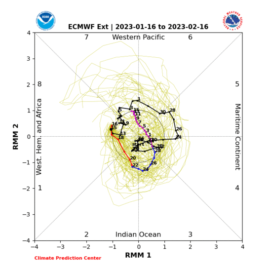
Euro now into p7 on the rmm plots.

-
2 hours ago, bluewave said:
Thanks for posting. A stronger phase 7 could set up a -EPO gradient pattern in late January.


Great call with the wave 6 amplitude. What was the reason for this?
-
11 minutes ago, Brian5671 said:
I would think we could see a crazy storm (liquid or frozen) somewhere with this???
Depends on where the boundary sets up. But yes, like we been seeing all winter, we would have very wet systems with cold air near by.
-
1
-
-
@bluewave looks like the stronger wave will help amplitude in p7 now also. As you said a few days ago, p8 by the start of February.
You can also see the building substance in the warm phases which is nice to see. Substance is sinking air which won’t allow for convection development.

-
2
-
-
Some really nice looks on the ensembles for the end of January. I still like the 17-19th for a swfe/overrunning storm. Before that we get the torch effects of p5/6.

-
1
-
-
Light rain lol this winter
-
5 hours ago, bluewave said:
That’s actually one of the EPS biases. It tends to be too weak with MJO 6 after phase 5. Probably another reason that we could see plenty of model volatility after phase 5.
https://journals.ametsoc.org/doi/full/10.1175/JCLI-D-15-0862.1

I always thought it was the RMM plots with the bias, thanks for the information. Nice call on the stronger wave in p6. Looks like we might slow down a bit in that phase and get to 7 by the end of the month.

-
1
-


January 2020 General Discussions & Observations Thread
in New York City Metro
Posted
The pattern gets better after the 20th. We have a chance at a snow to rain type event next weekend. After that it looks stormy with cold around. But yes, if you’re looking for a classic snowstorm it will be after the 20th. Incredible agreement right now with all the ensembles on a +pna and -epo look.