donsutherland1
-
Posts
23,763 -
Joined
Content Type
Profiles
Blogs
Forums
American Weather
Media Demo
Store
Gallery
Everything posted by donsutherland1
-
FWIW, I ran the numbers and also came up with a slightly decreasing trendline. Avondale is warming slightly faster than Philadelphia.
-
July 2025 Discussion-OBS - seasonable summer variability
donsutherland1 replied to wdrag's topic in New York City Metro
Tomorrow could be unhealthy. Then, we'll see whether the heavy rain later tomorrow and Friday can wash the particulates out of the air. -
I agree. Paris provides a good example of the benefits of greening.
-
July 2025 Discussion-OBS - seasonable summer variability
donsutherland1 replied to wdrag's topic in New York City Metro
it reached 100° at 4:40 pm. -
July 2025 Discussion-OBS - seasonable summer variability
donsutherland1 replied to wdrag's topic in New York City Metro
Newark reached 100° a short time ago. -
July 2025 Discussion-OBS - seasonable summer variability
donsutherland1 replied to wdrag's topic in New York City Metro
Temperatures again soared well into the 90s across the region. High temperatures included: Bridgeport: 95° (tied record set in 1949) Islip: 96° (old record: 95°, 1988) New York City-Central Park: 95° New York City-JFK Airport: 95° New York City-LaGuardia Airport: 99° (tied record set in 1988) Newark: 100° A break in the heat is now imminent. A front will cross the region this evening triggering some scattered showers and thundershowers. A few areas could experience strong or severe thunderstorms. Behind the front, it will turn cooler for an extended period of time. A widespread 1.00"-2.00" rainfall with locally higher amounts of 3.00" or more is likely from tomorrow night into Saturday. Generally somewhat cooler than normal conditions will likely persist through the first week of August. There are hints on the long-range guidance that a new round of heat could develop past August 10th. The ENSO Region 1+2 anomaly was +0.6°C and the Region 3.4 anomaly was -0.2°C for the week centered around July 23. For the past six weeks, the ENSO Region 1+2 anomaly has averaged +0.48°C and the ENSO Region 3.4 anomaly has averaged 0.00°C. Neutral ENSO conditions will likely continue through the summer. The SOI was +5.97 today. The preliminary Arctic Oscillation (AO) was -0.052 today. Based on sensitivity analysis applied to the latest guidance, there is an implied near 100% probability that New York City will have a warmer than normal July (1991-2020 normal). July will likely finish with a mean temperature near 79.5° (2.0° above normal). -
Occasional Thoughts on Climate Change
donsutherland1 replied to donsutherland1's topic in Climate Change
Glacial boulders at Franconia Notch State Park. The last boulder was split by the melting and refreezing of the ice. The boulders were deposited around 25,000 years ago as the ice sheet advanced south.


-
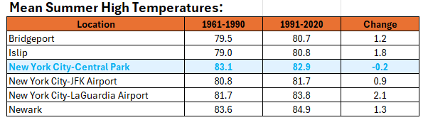
Trees have a cooling effect. In a way, Central Park is providing a demonstration of how trees can blunt at least some of the warming that is ongoing. Here's how things have fared in terms of average summer high temperatures 1961-1990 and 1991-2020 in the New York City area. Central Park is the lone sight showing a slight cooling of mean summer high temperatures.
-
July 2025 Discussion-OBS - seasonable summer variability
donsutherland1 replied to wdrag's topic in New York City Metro
Islip reached 95 for the fifth time this year. That ties 2025 with 1966 and 2010 for the second most such days. The record of seven days was set in 1999. -
I suspect that its urban heat island grew since the 1960s-1970s.
-
2025-2026 ENSO
donsutherland1 replied to 40/70 Benchmark's topic in Weather Forecasting and Discussion
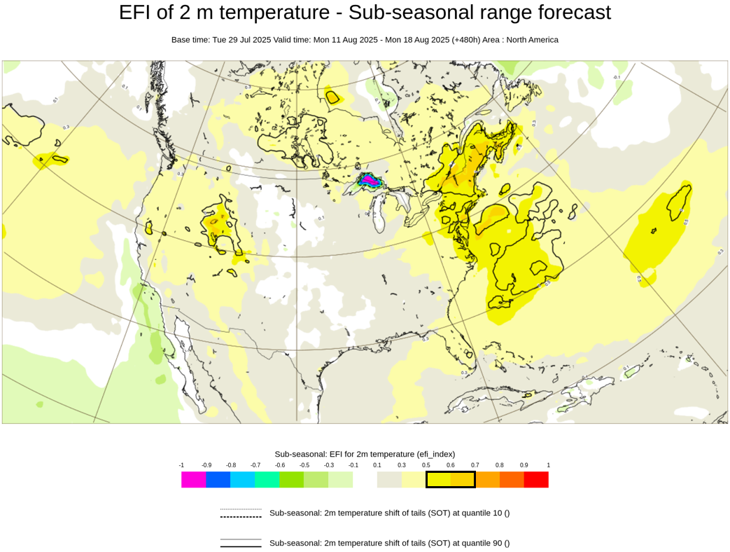
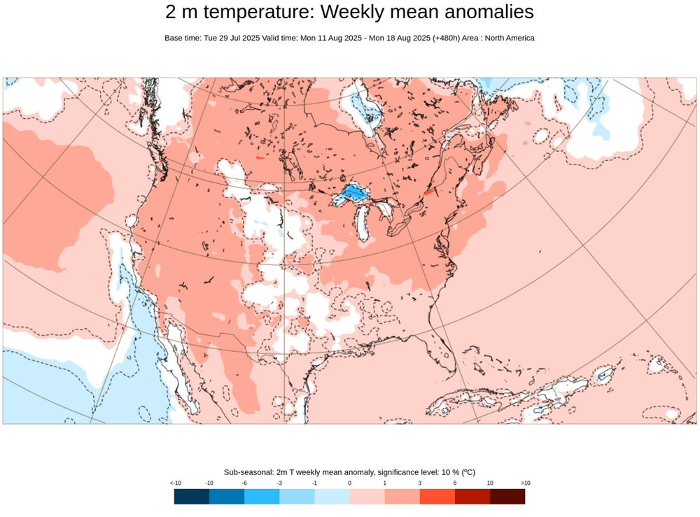
There's a pretty prominent heat signal showing up for parts of the East during the week of August 11-18:
-
If the numbers are taken as is, there would be 90s. The signal gets damped down over time due to the spread among the ensemble members. It's still fairly prominent at this timeframe.
-
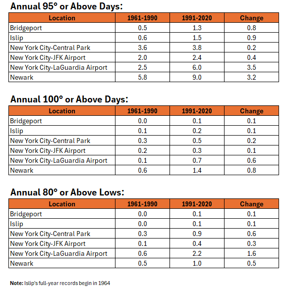
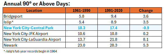
Here's how 90° or above days have changed in frequency between 1961-1990 and 1991-2020.
-
90° Days through July 29: Newark: 28 days New York City-LaGuardia Airport: 19 days Bridgeport and New York City-JFK Airport: 13 days Islip and White Plains: 11 days New York City-Central Park: 10 days The following sites have among the five highest number of such days through July 29th: Bridgeport: Tied second Islip: Tied fifth New York City-JFK Airport: Tied third Newark: Tied fifth
-
Although August will start cool, there is a distinct heat signature showing up on the EFI chart for August 11-18. The period is also forecast to be warmer than normal on the ECMWF weekly guidance.
-
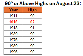
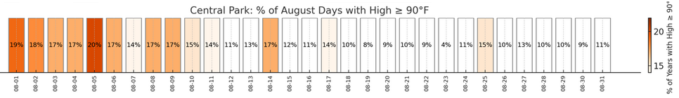
Historic frequency of 90° or above days at New York City (Central Park): August 23 is a statistical oddity with just 7 cases on which the temperature reached 90° or above. Only June 2-4 during summer had a similar or lower percentage of 90° days. September 7 was the next day with a similar figure. Then, the next similar or lower figure occurred on September 12.
-
Occasional Thoughts on Climate Change
donsutherland1 replied to donsutherland1's topic in Climate Change
About $7 trillion per year globally. That’s probably the most subsidized industry in history. https://www.imf.org/en/Topics/climate-change/energy-subsidies -
Central Park Conservancy and the NYC Parks Department.
-
They would still need approval to move it elsewhere in the Park.
-
July 2025 Discussion-OBS - seasonable summer variability
donsutherland1 replied to wdrag's topic in New York City Metro
JFK: 1983 NYC: 1944, 1949, 1953, 1954, 1955, 1966 -
Occasional Thoughts on Climate Change
donsutherland1 replied to donsutherland1's topic in Climate Change
Yes. While in Iceland a few years ago, the extent of the glacial retreat was stunning. In Portland, ME there are signs all along the waterfront noting the rising sea level and QR codes to learn more. The same can be found on Boston’s waterfront. While sailing on the Gulf of Maine, the boat’s captain stated that the Gulf is among the world’s fastest warming bodies of water and that the warming is having a noticeable impact on lobsters/fish (many are shifting north to the colder Canadian waters; sharks are following them north). I decided to press the issue so that cause-and-effect would be discussed and asked why the waters are warming so fast. He correctly said climate change is responsible and that the change has been very fast. All of these developments show that the warming is real, not an artifact of statistical adjustments in temperatures. -
July 2025 Discussion-OBS - seasonable summer variability
donsutherland1 replied to wdrag's topic in New York City Metro
Despite a cool start, August will likely be warmer than normal overall. There will be additional opportunities for 90+ heat especially after the 10th. -
July 2025 Obs/Disco ... possible historic month for heat
donsutherland1 replied to Typhoon Tip's topic in New England
Kennebunkport as the rain moves in.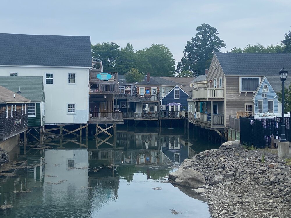
-
Winter cancelled/uncancelled banter 25/26
donsutherland1 replied to Rjay's topic in New York City Metro
Lion’s Mane Jellyfish (Rockland, ME):