donsutherland1
-
Posts
23,759 -
Joined
Content Type
Profiles
Blogs
Forums
American Weather
Media Demo
Store
Gallery
Everything posted by donsutherland1
-
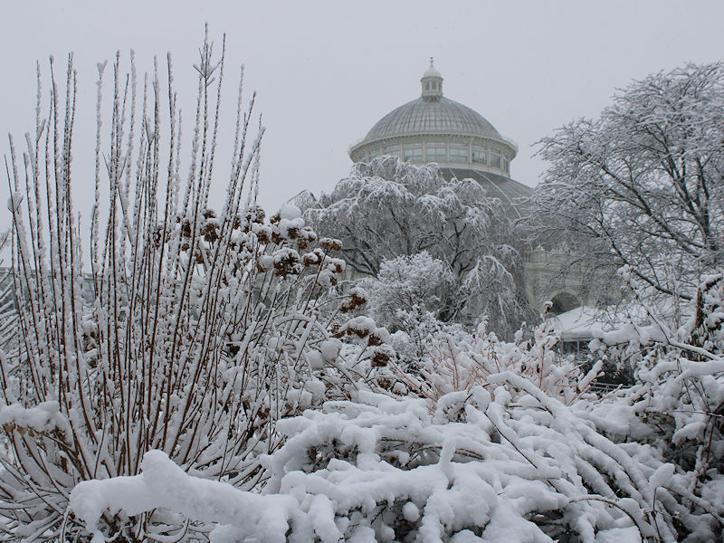
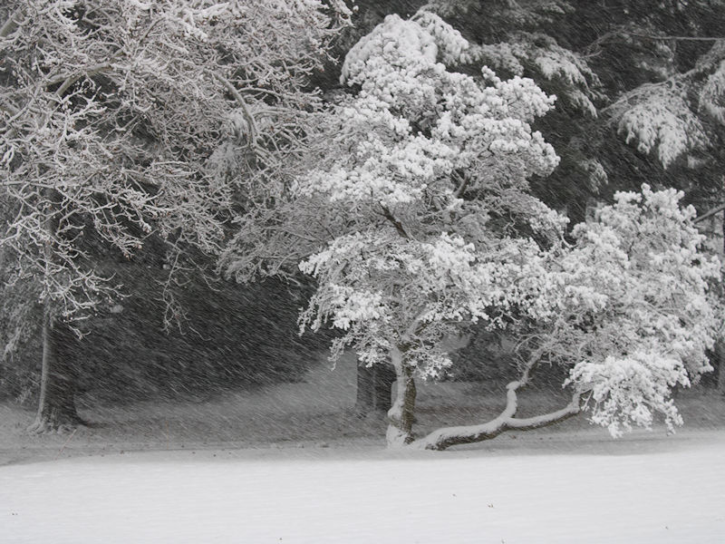
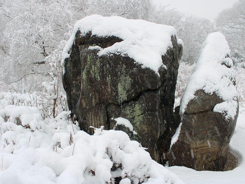
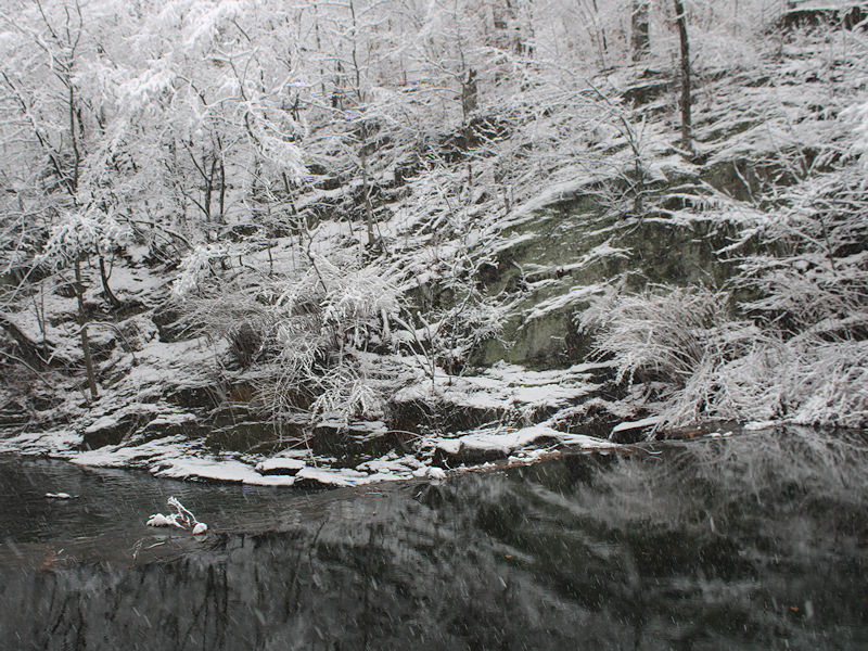
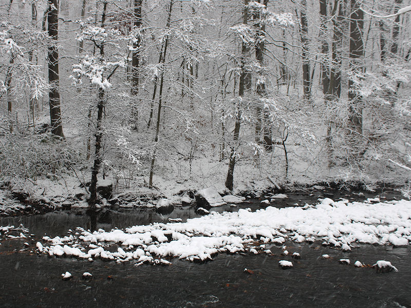
Some photos from the New York Botanical Garden this morning:

-
Not yet. Hopefully, soon.
-
2 NE Springfield, NJ: 4.5"
-
Snow will overspread the region tonight and continue into tomorrow. It should taper off to flurries during the middle or latter part of the morning in New York City and early afternoon on Long Island. The New York City area will see a general 3"-5" snowfall with some locally higher amounts. Final estimates: Allentown: 2"-4" Atlantic City: 3"-5" Baltimore: 3"-5" Bridgeport: 2"-4" Islip: 3"-6" New York City: 3"-5" Newark: 3"-5" Philadelphia: 3"-6" Poughkeepsie: 1"-3" Washington, DC: 2"-4" In the wake of the system, tomorrow and Monday will be blustery and cold days. High temperatures will likely wind up below freezing. The WPO has reached severely negative levels. That will likely contribute to the December 10-20 period being colder than normal overall. Moderation is possible late in the period as the WPO begins to rise. The probability that December 2025 will have a maximum monthly temperature below 60° is increasing. The last time that happened was in 2019 when the monthly high was 58°. If 2025 has a monthly high below 60°, that would be only the fifth such occurrence since 2000 (2003, 2004, 2005, and 2019 are the cases since 2000). The ENSO Region 1+2 anomaly was -0.2°C and the Region 3.4 anomaly was -0.5°C for the week centered around December 3. For the past six weeks, the ENSO Region 1+2 anomaly has averaged -0.27°C and the ENSO Region 3.4 anomaly has averaged -0.65°C. La Niña conditions will likely continue through at least mid-winter. The SOI was +4.62 today. The preliminary Arctic Oscillation (AO) was +1.254 today. Based on sensitivity analysis applied to the latest guidance, there is an implied near 91% probability that New York City will have a cooler than normal December (1991-2020 normal). December will likely finish with a mean temperature near 34.7° (4.4° below normal). Supplemental Information: The projected mean would be 2.7° below the 1981-2010 normal monthly value.
-
Boston's record stretch with < 4" and < 5" daily snowfall ended at 1,028 days on December 19, 2024. Boston currently has a 1,387-day streak with < 6" of daily snowfall, which is the second longest such streak. The record is 1,772 consecutive days.
-
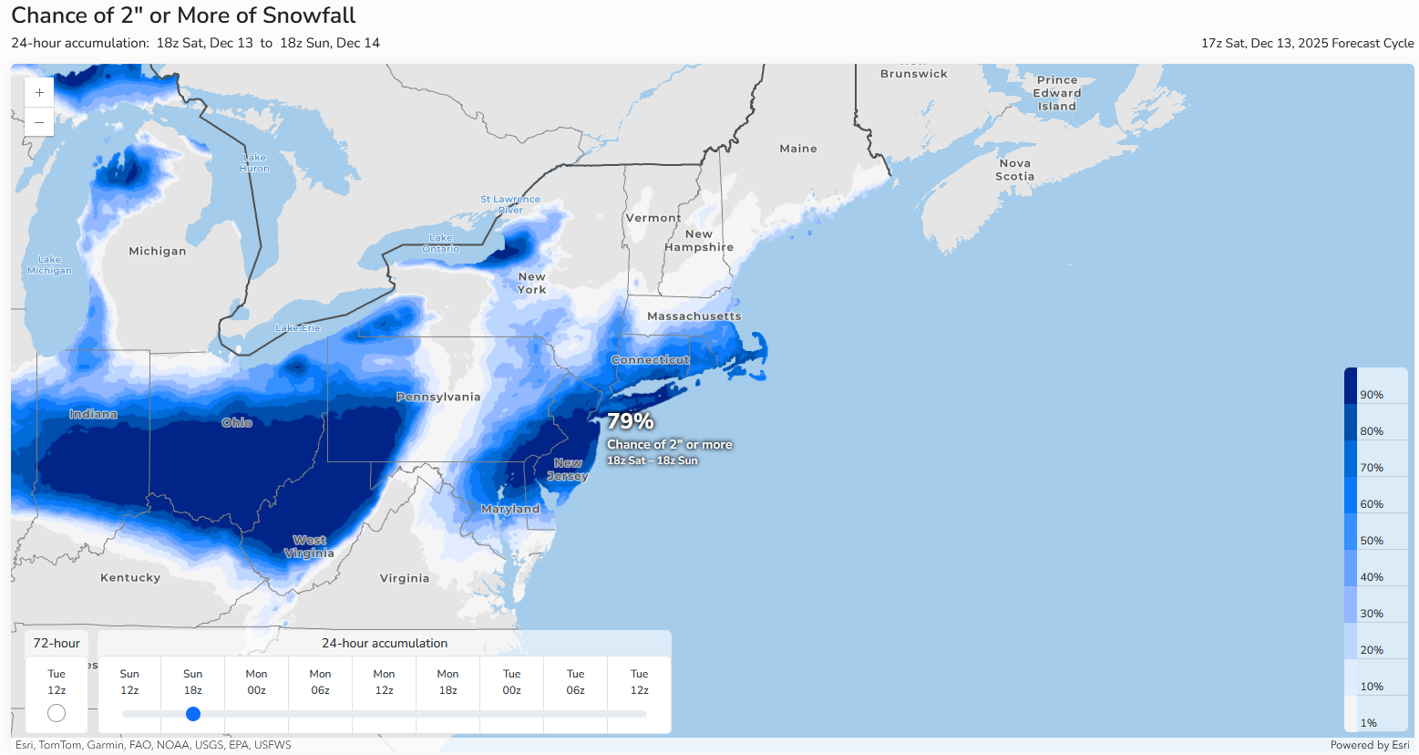
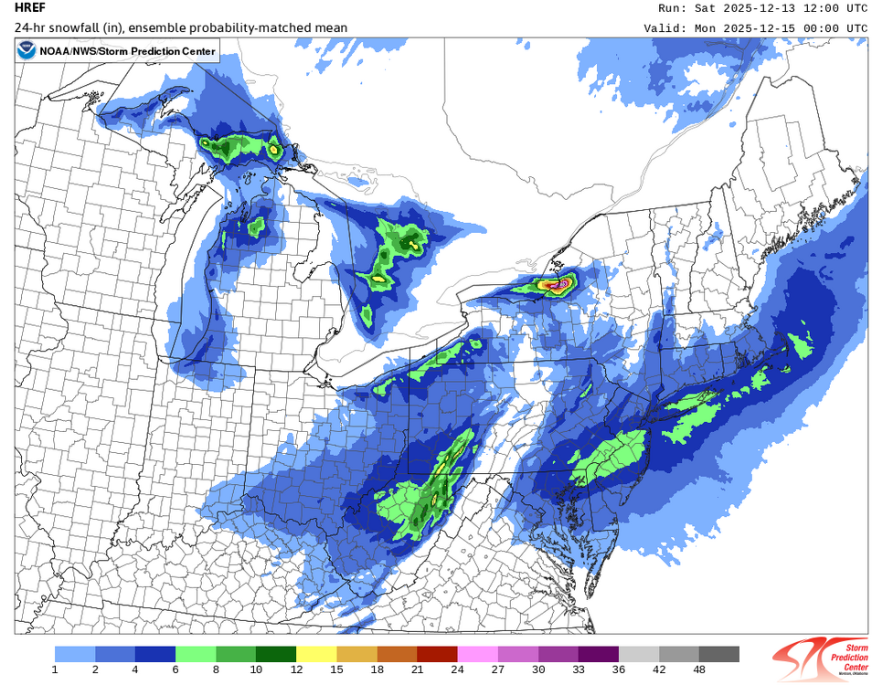
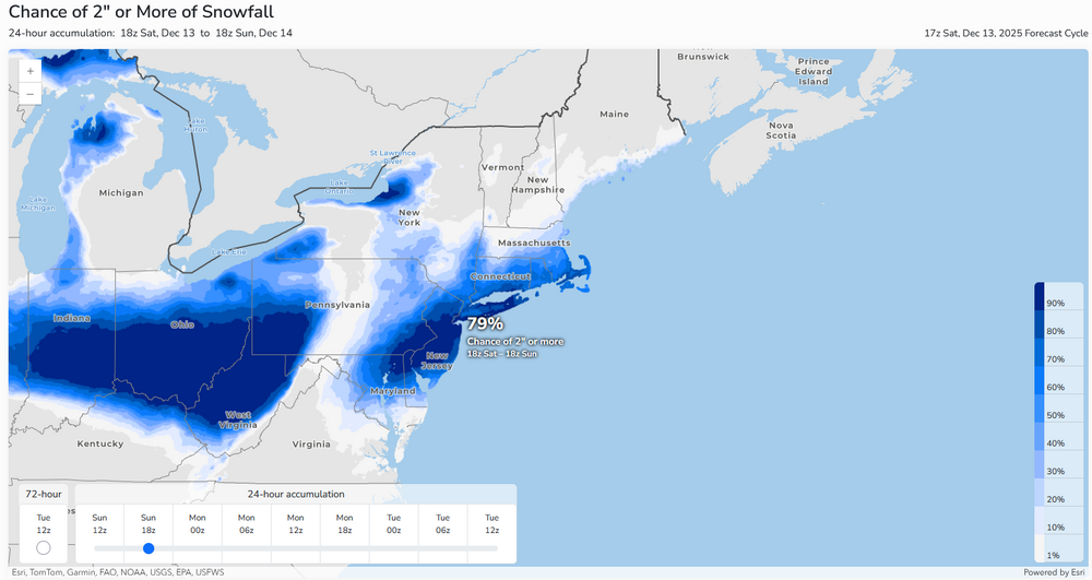
The 12/13 12z HREF is quite aggressive with the snowfall: If the areas are knocked down a level e.g., 4"-6" down to 2"-4", one still has good confidence in the idea of a widespread 2"-4" snowfall with higher amounts on parts of Long Island, NJ, and Philadelphia (generally 3"-6"). The latest probabilistic assessment of 2" or more snowfall.
-
I will check out Boston when I get home.
-
I enjoy all the snow I receive. Even 1 cm is appealing. Nevertheless, when posting statistics, even the ugly data (streak in my post) will be mentioned periodically for purposes of completeness.
-
For reference:
-
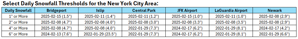
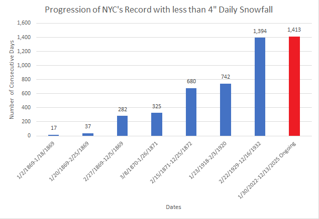
Overnight runs have added some QPF to the New York City region into central Westchester County and southern Fairfield County. Ratios will probably be 11:1 to 13:1 across a good part of the region. Taking all this into consideration, my thinking is that the New York City area, including its nearby northern suburbs will see a general 2"-4" snowfall. A portion of New Jersey and Long Island could see higher amounts, especially as some Atlantic moisture could become involved as the system departs e.g., Islip could wind up with a 3"-5" snowfall. Recent Snowfall Thresholds for New York City: Storm Total Snowfall: Last 1" or above snowfall: February 11-12, 2025: 1.6" Last 2" or above snowfall: February 8-9, 2025: 3.1" Last 4" or above snowfall: January 28-29, 2022: 8.5" Daily Snowfall: Last 1" or above snowfall: February 11, 2025: 1.2" Last 2" or above snowfall: February 8, 2025: 3.0" Last 4" or above snowfall: January 29, 2022: 7.3" Given the timing of the snow's onset, today will very likely extend the record streak without 4" or above snowfall to 1,414 consecutive days for New York City. Farther south, Philadelphia is in line for a 3"-6" snowfall. The last time Philadelphia saw a 4" or greater snowstorm was January 19, 2024 when 4.6" fell. Philadelphia's last 6" or above snowstorm occurred during January 28-29, 2022 when 7.5" blanketed the city.
-
It will be increasingly cloudy and cold tomorrow. Light to moderate snow will overspread the region tomorrow night. The New York City area will see a general 1"-3" snowfall with a few locally higher amounts. In the wake of the system, Sunday and Monday will be blustery and cold days. High temperatures will likely wind up below freezing. The WPO is falling toward severely negative levels. That will likely contribute to the December 10-20 period being colder than normal overall. Moderation is possible late in the period as the WPO begins to rise. The probability that December 2025 will have a maximum monthly temperature below 60° is increasing. The last time that happened was in 2019 when the monthly high was 58°. If 2025 has a monthly high below 60°, that would be only the fifth such occurrence since 2000 (2003, 2004, 2005, and 2019 are the cases since 2000). The ENSO Region 1+2 anomaly was -0.2°C and the Region 3.4 anomaly was -0.5°C for the week centered around December 3. For the past six weeks, the ENSO Region 1+2 anomaly has averaged -0.27°C and the ENSO Region 3.4 anomaly has averaged -0.65°C. La Niña conditions will likely continue through at least mid-winter. The SOI was -4.67 today. The preliminary Arctic Oscillation (AO) was +0.811 today. Based on sensitivity analysis applied to the latest guidance, there is an implied near 89% probability that New York City will have a cooler than normal December (1991-2020 normal). December will likely finish with a mean temperature near 34.8° (4.3° below normal). Supplemental Information: The projected mean would be 2.6° below the 1981-2010 normal monthly value.
-
2025-2026 ENSO
donsutherland1 replied to 40/70 Benchmark's topic in Weather Forecasting and Discussion
It should be abundantly clear now that the plausible scenario of a warmup within a few days of December 20 has become the baseline scenario. The weakening WPO- regime coupled with unfavorable teleconnections will allow for most of the CONUS to see temperatures move above normal. The ongoing warmth will continue in the West, as well. It is also increasingly clear that the PNA will wind up predominantly negative this month. Most of Canada should remain cold beyond December 20, however eastern Canada, including Ontario and Quebec could begin to warm up several days later. -
Winter cancelled/uncancelled banter 25/26
donsutherland1 replied to Rjay's topic in New York City Metro
Maybe the "boo-birds" will be throwing snow balls, not hot water, on Sunday. -
Occasional Thoughts on Climate Change
donsutherland1 replied to donsutherland1's topic in Climate Change
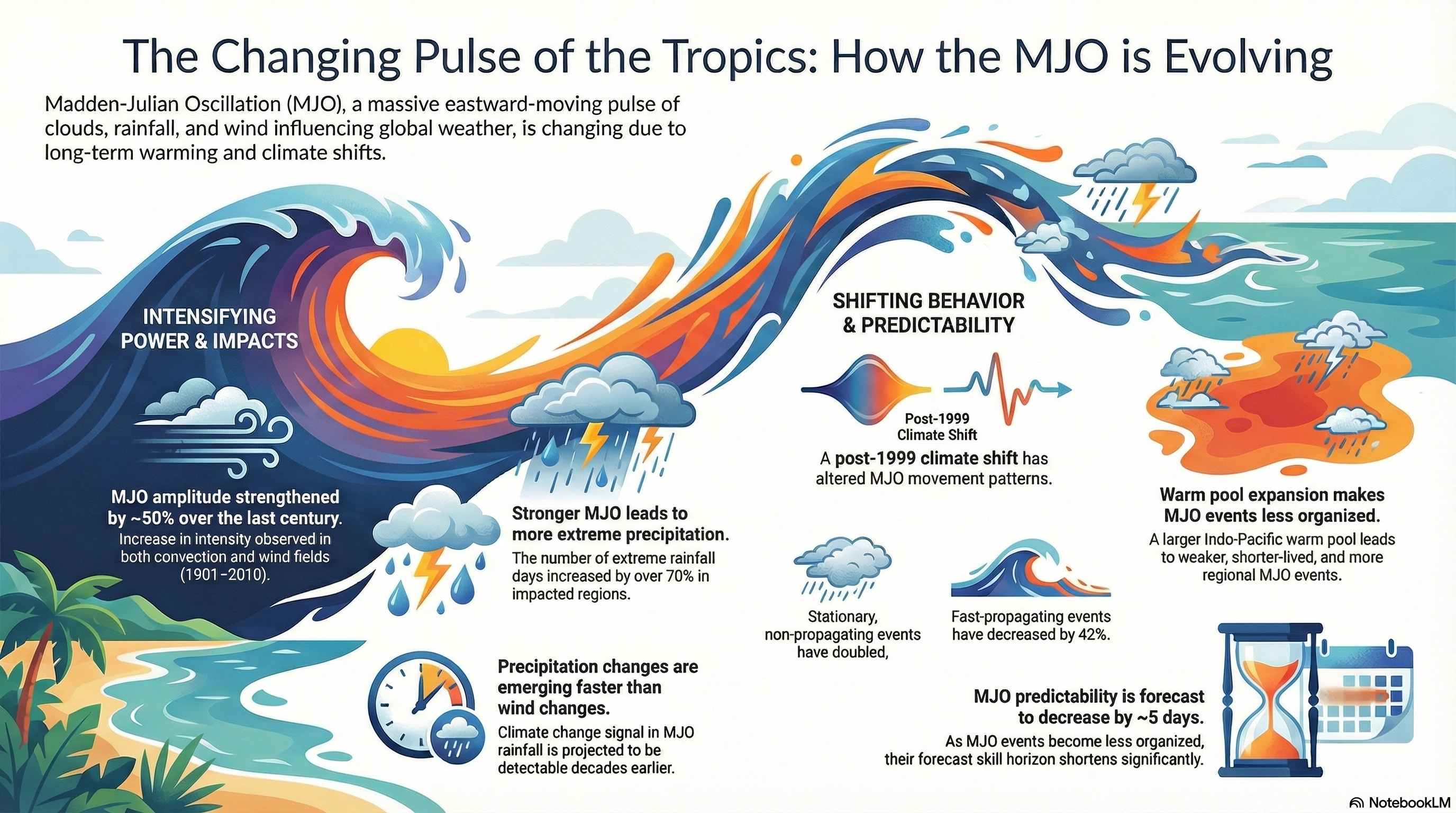
I put a number of papers on how climate change has affected the MJO (many thanks to @bluewave for providing links in a number of posts/threads) and used Notebook LM to generate an infographic. That infographic is based solely on the literature. It is below: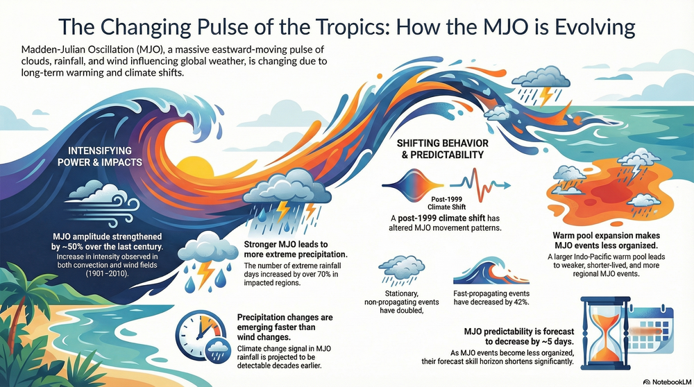
-
Yes, that's true. Parts of the FL might wind up having a top 10 warmest December. And many records are being set out West.
-
New York City finished December 1-10 with a mean temperature of 34.1F (1.2C). That was the coldest first 10 days of December since 2007 and sixth coldest since 2000. A quick look at the guidance shows that a light snow event (probably 1"-3") across the New York City area is likely on Sunday. Given how snow events have been challenging to come by in recent years, to some it might seem like a big event. Even the previously bone-dry NBM shows 0.12" QPF.
-
It will turn briefly milder tomorrow. Some rain showers are likely tomorrow night. Some wet snow showers could occur well north and west of New York City. It will then turn somewhat cooler for the remainder of the week, but the cold won't match today's chill. Light precipitation is possible during the weekend, especially on Sunday. The ongoing stretch of below normal temperatures will likely continue into or through the second week of December. December 1-10 will be a solidly colder than normal period. The potential exists for the coldest first 10 days of December since at least 2007 (33.4°, 5th coldest December 1-10 since 2000). The five coldest December 1-10 periods since 2000 were: 1. 30.6°, 2002 2. 32.2°, 2003 3. 32.4°, 2000 4. 33.1°, 2005 5. 33.4°, 2007 All 5 of these cases had measurable snowfall in Central Park. The WPO is forecast to become strongly negative beyond December 10th. That would likely contribute to the December 10-20 period also being colder to perhaps much colder than normal overall. The probability that December 2025 will have a maximum monthly temperature below 60° is increasing. The last time that happened was in 2019 when the monthly high was 58°. If 2025 has a monthly high below 60°, that would be only the fifth such occurrence since 2000 (2003, 2004, 2005, and 2019 are the cases since 2000). The ENSO Region 1+2 anomaly was -0.2°C and the Region 3.4 anomaly was -0.5°C for the week centered around December 3. For the past six weeks, the ENSO Region 1+2 anomaly has averaged -0.27°C and the ENSO Region 3.4 anomaly has averaged -0.65°C. La Niña conditions will likely continue through at least mid-winter. The SOI was +17.96 today. The preliminary Arctic Oscillation (AO) was -0.921 today. Based on sensitivity analysis applied to the latest guidance, there is an implied near 91% probability that New York City will have a cooler than normal December (1991-2020 normal). December will likely finish with a mean temperature near 34.1° (5.0° below normal). Supplemental Information: The projected mean would be 3.4° below the 1981-2010 normal monthly value.
-
2025-2026 ENSO
donsutherland1 replied to 40/70 Benchmark's topic in Weather Forecasting and Discussion
No disagreement. We often see the same in the NCAA tournament with numerous 10+ loss teams making it. I guess they will be the NAM of the CFP. -
2025-2026 ENSO
donsutherland1 replied to 40/70 Benchmark's topic in Weather Forecasting and Discussion
Alabama. After Georgia routed Alabama, he’s feeling the pain. -
2025-2026 ENSO
donsutherland1 replied to 40/70 Benchmark's topic in Weather Forecasting and Discussion
IMO, La Niña will fade during January. It still has some life left in it.
-
Meteorology career prospects (AI impact? NOAA cuts?)
donsutherland1 replied to WolfStock1's topic in Meteorology 101
I'm surprised that no one responded from the field. More than likely, it's because they also don't know. Here's a link to the Occupational Outlook Handbook (forecast slower than average growth in meteorologists/atmospheric scientists): https://www.bls.gov/ooh/life-physical-and-social-science/atmospheric-scientists-including-meteorologists.htm#tab-6 Although the link was updated in August, it does not appear to fully encompass the role of AI. That's probably because a lot is not yet certain. But if evidence from early inroads by AI in such fields as accounting, computer science, etc., is representative, AI could reshape the profession, shifting it away from forecast production to risk interpretation/impact communication. Basic forecasting, which is algorithmic in nature, could become far more automated than it is today. The meteorology profession will likely shift the human focus to areas that can't easily be replicated by algorithms or machine learning. At the same time, meteorologists will likely need additional skills in areas of machine learning, data science, and AI training due to their much greater exposure to AI/AI-related tools. Depending on when your son might pursue a degree, the curriculum could differ from what it is today. Prospective colleges/universities can provide greater insight. -
Tomorrow will be an unseasonably cold day. The morning low could dip below 20° in Central Park and could rival or even surpass the cold of December 5th at some locations. The ongoing stretch of below normal temperatures will likely continue into or through the second week of December. December 1-10 will be a solidly colder than normal period. The potential exists for the coldest first 10 days of December since at least 2007 (33.4°, 5th coldest December 1-10 since 2000). The five coldest December 1-10 periods since 2000 were: 1. 30.6°, 2002 2. 32.2°, 2003 3. 32.4°, 2000 4. 33.1°, 2005 5. 33.4°, 2007 All 5 of these cases had measurable snowfall in Central Park. The WPO is forecast to become strongly negative beyond December 10th. That would likely contribute to the December 10-20 period also being colder to perhaps much colder than normal overall. The probability that December 2025 will have a maximum monthly temperature below 60° is increasing. The last time that happened was in 2019 when the monthly high was 58°. If 2025 has a monthly high below 60°, that would be only the fifth such occurrence since 2000 (2003, 2004, 2005, and 2019 are the cases since 2000). The ENSO Region 1+2 anomaly was -0.2°C and the Region 3.4 anomaly was -0.5°C for the week centered around December 3. For the past six weeks, the ENSO Region 1+2 anomaly has averaged -0.27°C and the ENSO Region 3.4 anomaly has averaged -0.65°C. La Niña conditions will likely continue through at least mid-winter. The SOI was +11.57 today. The preliminary Arctic Oscillation (AO) was -1.926 today. Based on sensitivity analysis applied to the latest guidance, there is an implied near 88% probability that New York City will have a cooler than normal December (1991-2020 normal). December will likely finish with a mean temperature near 34.3° (4.8° below normal). Supplemental Information: The projected mean would be 3.2° below the 1981-2010 normal monthly value.
-
2025-2026 ENSO
donsutherland1 replied to 40/70 Benchmark's topic in Weather Forecasting and Discussion
So far, things have gone pretty much as expected in December. The December 1-10 idea is verifying. The big question concerning late December is whether the WPO- will weaken allowing unfavorable teleconnections to reshape the pattern. That is a possibility, but isn't certain. Other possibilities also exist.
-
Statistical tidbit from 1990-91 through 2024-25: 14/15 (93%) of winters with above normal seasonal snowfall had a least one day with 8" or more snow (72% prior to 1990-91) 17/18 (94%) of winters with below normal seasonal snowfall did not have any 8" or above daily amounts (75% prior to 1990-91) 14/17 (82%) of winters with at least one day with 8" or above snowfall had above normal seasonal snowfall (63% prior to 1990-91) 2014-15 with 50.3" seasonal snowfall was the lone exception for seasons with above normal snowfall with a maximum daily amount of 7.5" since 1990-91. This data suggests that in the contemporary warmer climate, a big snowstorm has become relatively more important to seasonal snowfall outcomes than in the past. Both subsets are longer than 30 seasons in length suggesting that the difference provides some insight. Moreover, this is what would be expected in a warmer climate with somewhat fewer snowy days.
-
2025-2026 ENSO
donsutherland1 replied to 40/70 Benchmark's topic in Weather Forecasting and Discussion
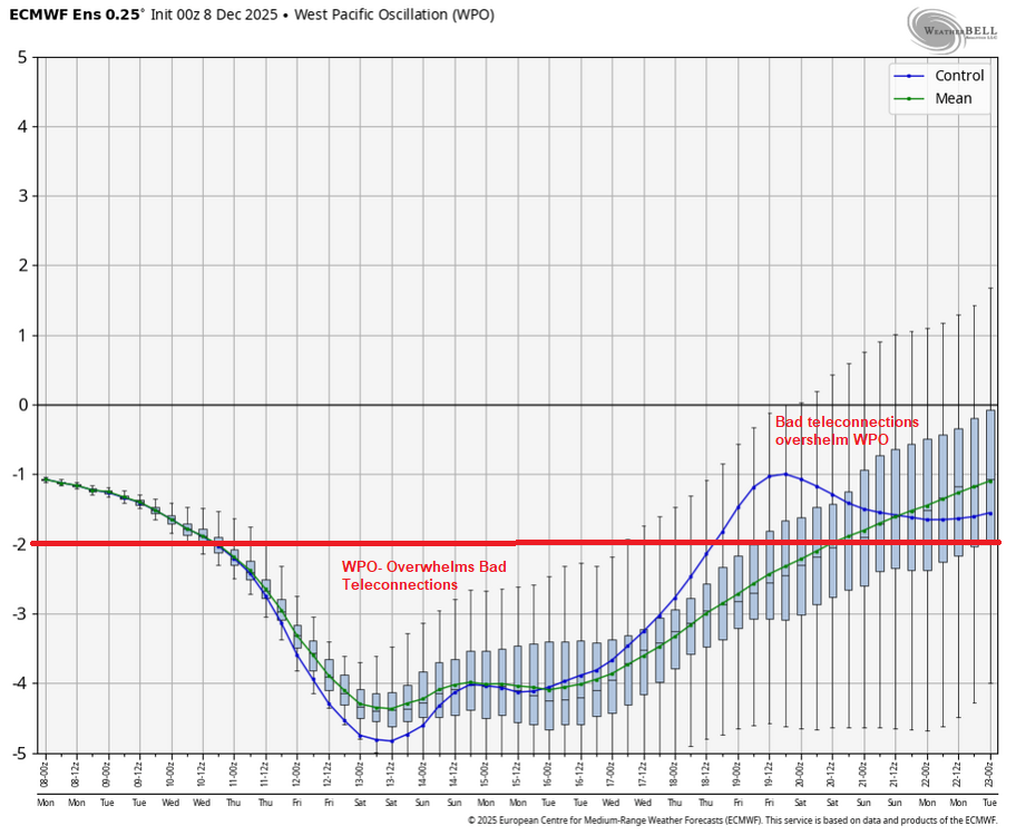
Below is why a relaxation is possible during December 20-31. The WPO is forecast to become less negative while a PNA-, EPO+,AO+, NAO+ regime is largely in place. The WPO would no longer be sufficiently negative to offset the impact of unfavorable teleconnections. Fortunately, that's still far out where skill is low, so it's a plausible but not yet certain outcome.