

donsutherland1
-
Posts
23,782 -
Joined
Content Type
Profiles
Blogs
Forums
American Weather
Media Demo
Store
Gallery
Everything posted by donsutherland1
-
Morning thoughts… It will be partly sunny and milder today. High temperatures will likely reach mainly the lower and middle 40s in most of the region. Likely high temperatures around the region include: New York City (Central Park): 44° Newark: 47° Philadelphia: 46° Normals: New York City: 30-Year: 42.8°; 15-Year: 43.6° Newark: 30-Year: 43.3°; 15-Year: 44.3° Philadelphia: 30-Year: 44.5°; 15-Year: 45.6° Another brief push of cooler air is likely on Thursday before readings again warm up.
-
Almost certainly, the 1870-71 date is incorrect. On December 28, 1870, the high temperature was 32 and 0.10” precipitation fell. On December 30, the temperature range was 30-10 and 0.05” precipitation was recorded. The NWS .pdf shows 3.0” snow in December 1870. https://www.weather.gov/media/okx/Climate/CentralPark/monthlyseasonalsnowfall.pdf
-
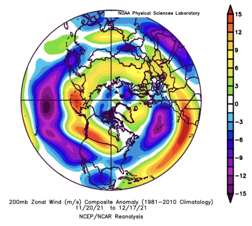
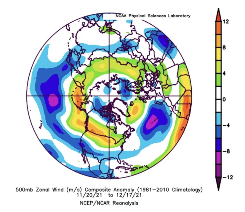
Despite ample sunshine, readings were held much below normal today. But following another cold night, winter will lose its grip on the region, yet again. Temperatures will begin to moderate tomorrow. There will be one additional brief push of modestly colder air on Thursday. Overall, temperatures will generally be near or above normal throughout much of the remainder of December. The final week of December could still see temperatures begin to turn colder as month ends. No severe cold is likely. Afterward, if the small sample of cases where the MJO moved into Phase 7 at a high amplitude (1.75 or above) during the December 10-20 period, as occurred this month, is representative, the first 10 days of January could see below to perhaps much below normal temperatures. However, the coldest air will likely remain confined to the Pacific Northwest, Northern Plains, and western and central Canada for much of this period. January will likely commence with an AO-/PNA- pattern. That typically favors somewhat cooler than normal readings in the East. For NYC, the January 1-10, 1991-2020 mean temperature for such cases was 33.5° (normal: 34.8°). There are some hints that a milder pattern could begin to develop around mid-January. In the Midwest, Chicago has yet to receive its first measurable snowfall through 4 pm CST on December 20, 2021 has now tied the record for Chicago's latest first measurable snowfall. The existing record was set on December 20, 2012. That record is all but certain to be broken tomorrow. Following very wet July-September periods, winter (December-February) precipitation has typically been near or below normal. The most recent exception was winter 2018-19. The ENSO Region 1+2 anomaly was -1.4°C and the Region 3.4 anomaly was -1.1°C for the week centered around December 8. For the past six weeks, the ENSO Region 1+2 anomaly has averaged -1.00°C and the ENSO Region 3.4 anomaly has averaged -0.92°C. La Niña conditions will likely persist into at least late winter. The SOI was -9.81 today. The preliminary Arctic Oscillation (AO) figure was -1.950 today. On December 18 the MJO was in Phase 6 at an amplitude of 1.681 (RMM). The December 17-adjusted amplitude was 1.867 (RMM). Based on sensitivity analysis applied to the latest guidance, there is an implied 98% probability that New York City will have a warmer than normal December (1991-2020 normal). December will likely finish with a mean temperature near 42.6° (3.5° above normal).
-
Morning thoughts… It will be mostly sunny and unseasonably cold today. High temperatures will likely reach mainly the middle and upper 30s with perhaps a few lower 40s in most of the region. Likely high temperatures around the region include: New York City (Central Park): 37° Newark: 40° Philadelphia: 41° Normals: New York City: 30-Year: 43.0°; 15-Year: 43.8° Newark: 30-Year: 43.5°; 15-Year: 44.5° Philadelphia: 30-Year: 44.8°; 15-Year: 45.8° Milder air will return on tomorrow.
-
A stiff wind was drilling colder air into the region this evening creating mid-winter wind chills. Tomorrow morning could see the coldest readings so far this season. And then, winter will lose its grip on the region. Temperatures will moderate beginning on Tuesday. Temperatures will generally be near or above normal through much of the remainder of December. The final week of December could still see temperatures begin to turn colder as month comes to a close. No severe cold is likely. Afterward, if the small sample of cases where the MJO moved into Phase 7 at a high amplitude (1.75 or above) during the December 10-20 period, as occurred this month, is representative, the first 10 days of January could see below to perhaps much below normal temperatures. Support for such an outcome has increased on the recent guidance. Currently, the risk of severe cold at the start of January remains relatively low. There remains uncertainty concerning the magnitude and duration of the cold during the first 10 days of January. In the Midwest, Chicago has yet to receive its first measurable snowfall through 4 pm CST on December 19. Only December 2012 saw saw its first measurable snowfall after December 19 (December 20). Following very wet July-September periods, winter (December-February) precipitation has typically been near or below normal. The most recent exception was winter 2018-19. The ENSO Region 1+2 anomaly was -1.4°C and the Region 3.4 anomaly was -1.1°C for the week centered around December 8. For the past six weeks, the ENSO Region 1+2 anomaly has averaged -1.00°C and the ENSO Region 3.4 anomaly has averaged -0.92°C. La Niña conditions will likely persist into at least late winter. The SOI was -2.13 today. The preliminary Arctic Oscillation (AO) figure was -1.250 today. On December 17 the MJO was in Phase 6 at an amplitude of 1.867 (RMM). The December 16-adjusted amplitude was 2.010 (RMM). Based on sensitivity analysis applied to the latest guidance, there is an implied 97% probability that New York City will have a warmer than normal December (1991-2020 normal). December will likely finish with a mean temperature near 42.6° (3.5° above normal).
-
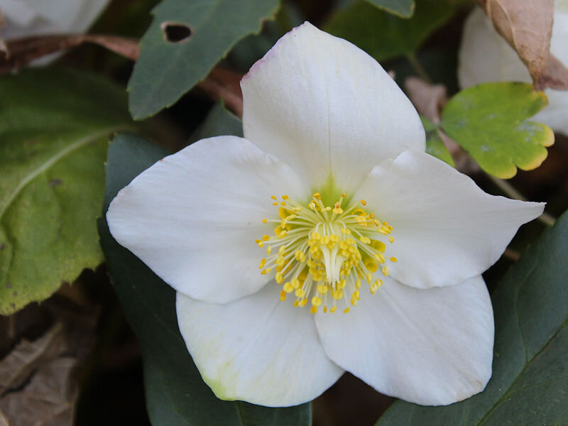
It’s now past mid-December. Yet, a lot still remains in bloom at the New York Botanical Garden:


-
I agree with you. I remain hopeful that we’ll have some snowfall opportunities.
-
Here’s what I could find:
-
Yes.
-
Morning thoughts… Clouds will break from west to east as the day progresses. Temperatures will only rise slightly as colder air pours into the region. High temperatures will likely reach the upper 30s and perhaps lower 40s in most of the region. Likely high temperatures around the region include: New York City (Central Park): 42° Newark: 44° Philadelphia: 45° Normals: New York City: 30-Year: 43.3°; 15-Year: 44.1° Newark: 30-Year: 43.8°; 15-Year: 44.8° Philadelphia: 30-Year: 45.0°; 15-Year: 46.0° Tomorrow will be fair but unseasonably cold. Milder air will likely return on Tuesday.
-
Colder air will begin to return to the region tonight and tomorrow. Monday morning could see the coldest readings so far this season, but the cold shot will be a brief one. Temperatures will likely moderate beginning on Tuesday. The final week of December could see temperatures begin to turn colder as month comes to a close. No severe cold is likely. Afterward, if the small sample of cases where the MJO moved into Phase 7 at a high amplitude (1.75 or above) during the December 10-20 period, as occurred this month, is representative, the first 10 days of January could see below to perhaps much below normal temperatures. Support for such an outcome has increased on the recent guidance. Currently, the risk of severe cold at the start of January remains relatively low. There remains uncertainty concerning the magnitude and duration of the cold during the first 10 days of January. In the Midwest, Chicago has yet to receive its first measurable snowfall through 4 pm CST on December 18. Only December 2012 saw saw its first measurable snowfall after December 16 (December 20). Following very wet July-September periods, winter (December-February) precipitation has typically been near or below normal. The most recent exception was winter 2018-19. The ENSO Region 1+2 anomaly was -1.4°C and the Region 3.4 anomaly was -1.1°C for the week centered around December 8. For the past six weeks, the ENSO Region 1+2 anomaly has averaged -1.00°C and the ENSO Region 3.4 anomaly has averaged -0.92°C. La Niña conditions will likely persist into at least late winter. The SOI was +8.93 today. The preliminary Arctic Oscillation (AO) figure was -0.889 today. On December 16 the MJO was in Phase 6 at an amplitude of 2.005 (RMM). The December 15-adjusted amplitude was 1.974 (RMM). Based on sensitivity analysis applied to the latest guidance, there is an implied 94% probability that New York City will have a warmer than normal December (1991-2020 normal). December will likely finish with a mean temperature near 42.4° (3.3° above normal).
-
Morning thoughts… Today will be mostly cloudy with some showers and light rain. High temperatures will likely reach the upper 40s and perhaps lower 50s in most of the region. Likely high temperatures around the region include: New York City (Central Park): 47° Newark: 49° Philadelphia: 54° Normals: New York City: 30-Year: 43.5°; 15-Year: 44.3° Newark: 30-Year: 44.0°; 15-Year: 45.0° Philadelphia: 30-Year: 45.3°; 15-Year: 46.2° A brief shot of cold air will move into the region tonight. Milder air will likely return on Tuesday.
-
Get well soon.
-
Not during the first week of December. Here’s the list:
-
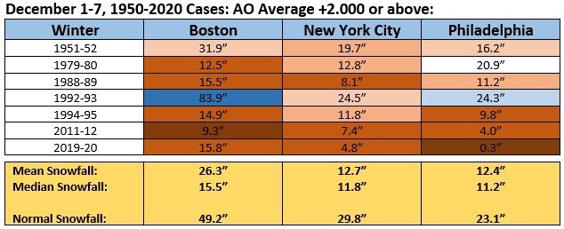
Historically, winters that start with the kind of AO+ one saw during the first week of December wind up with below to much below normal snowfall.
-
It would probably be very difficult to get a January 1985 outcome given the strongly negative PDO (it was positive during winter 1984-85).
-
Today was another very mild day. Records again fell at some locations including: Burlington: 60° (old record: 56°, 2000) Grand Étang, NS: 47° (old record: 43°, 2005) Montreal: 55° (old record: 51°, 1984) ***record 222nd 50° day*** New Haven: 60° (old recorfd: 55°, 2015) New York City-JFK: 61° (old record: 59°, 1984 and 2015) New York City-LGA: 62° (old record: 61°, 2000) Saguenay, QC: 44° (old record: 40°, 2006) Worcester: 60° (tied record set in 2000) Colder air will begin to return to the region this following a frontal passage tomorrow. A few showers or periods of rain are possible tonight and tomorrow. Parts of the Hudson Valley and northwestern Connecticut could experience some snow and sleet with minor accumulations. Early next week could briefly see the coldest temperatures so far this season before some moderation again sets in. The final week of December could see temperatures shift below normal as the month comes to a close. No severe cold is likely. Afterward, if the small sample of cases where the MJO moved into Phase 7 at a high amplitude (1.75 or above) during the December 10-20 period, as occurred this month, is representative, the first 10 days of January could see below to perhaps much below normal temperatures. Both the magnitude and duration of the cold is uncertain. In the Midwest, Chicago has yet to receive its first measurable snowfall through December 16. Only two prior years saw their first measurable snowfall on December 16 or later: 1. December 20, 2012 2. December 16, 1965 The front that will produce tomorrow's precipitation could bring some measurable snow to Chicago tonight. However, there remains a chance that no accumulations will occur there. Following very wet July-September periods, winter (December-February) precipitation has typically been near or below normal. The most recent exception was winter 2018-19. The ENSO Region 1+2 anomaly was -1.4°C and the Region 3.4 anomaly was -1.1°C for the week centered around December 8. For the past six weeks, the ENSO Region 1+2 anomaly has averaged -1.00°C and the ENSO Region 3.4 anomaly has averaged -0.92°C. La Niña conditions will likely persist into at least late winter. The SOI was +11.05 today. The preliminary Arctic Oscillation (AO) figure was -0.145 today. On December 15 the MJO was in Phase 6 at an amplitude of 1.973 (RMM). The December 14-adjusted amplitude was 2.034 (RMM). Based on sensitivity analysis applied to the latest guidance, there is an implied 90% probability that New York City will have a warmer than normal December (1991-2020 normal). December will likely finish with a mean temperature near 42.2° (3.1° above normal).
-
MJO forecasts beyond day 7 are not very skillful. The SSTAs suggest caution—and the SSTAs, not Rai may be more responsible for the ongoing evolution of the MJO. A push into Phase 8 is not a foregone conclusion. The MJO could well fall into low amplitudes only to re-emerge at a higher amplitude in a warmer phase. Thus, it’s plausible that any colder pattern could fall apart after about 2 weeks (mid-January?).
-
The latest GEFS maps illustrate the need for patience. Some colder air could begin to spill into the region as December concludes, but the odds remain against a full-fledged Arctic blast. The magnitude and duration of a possible cold period in January remains uncertain. It remains possible that the severe cold in Alaska and western Canada may largely avoid the region.
-
JFK Airport has reached 60 degrees. That breaks the daily record of 59 set in 1984 and tied in 2015.
-
Morning thoughts… Today will be partly cloudy and very mild. High temperatures will likely reach the upper 50s and perhaps lower 60s in most of the region. Likely high temperatures around the region include: New York City (Central Park): 59° Newark: 60° Philadelphia: 60° Normals: New York City: 30-Year: 43.8°; 15-Year: 44.6° Newark: 30-Year: 44.3°; 15-Year: 45.2° Philadelphia: 30-Year: 45.5°; 15-Year: 46.5° The unseasonably mild weather will continue into the start of the weekend.
-
Under partly sunny skies, temperatures soared into the 50s and 60s across the region. Numerous records were shattered or tied in parts of the Northeast and southern Canada. Records included: Albany: 61° (old record: 55°, 1971) Allentown: 61° (old record: 60°, 1971) Binghamton: 60° (old record: 54°, 1971) Buffalo: 64° (tied record set in 1984) Burlington: 58° (old record: 54°, 1982) Grand Rapids, MI: 63° (old record: 61°, 1984) Green Bay: 65° (old record: 54°, 1984) ***new December record*** Harrisburg: 66° (old record: 63°, 1971) Hartford: 63° (old record: 60°, 1971) Lansing: 63° (old record: 60°, 1971) Madison: 63° (old record: 57°, 1959) Manchester, NH: 56° (old record: 54°, 2008) Milwaukee: 68° (old record: 58°, 1984) ***new December record*** Montreal: 59° (old record: 50°, 1992) Mount Pocono, PA: 60° (old record: 56°, 1906) New York City-LGA: 63° (old record: 62°, 1971) Newark: 65° (tied record set in 1971) Ottawa: 59° (old record: 45°, 1984) Pittsburgh: 64° (tied record set in 1940) Poughkeepsie: 64° (old record: 59°, 1971) Providence: 65° (old record: 62°, 1971) Rochester: 65° (old record: 62°, 1894) Rockford, IL: 68° (old record: 58°, 1984) Scranton: 65° (old record: 57°, 1971) Syracuse: 67° (old record: 55°, 1971) Toronto: 63° (old record: 60°, 1984) Watertown, NY: 63° (old record: 54°, 1971) Williamsport, PA: 60° (old record: 58°, 1971) Worcester: 58° (tied record set in 1971) Tomorrow will be another very mild day. However, colder air will begin to return to the region this weekend. Early next week could briefly see the coldest temperatures so far this season before some moderation again sets in. There is growing model consensus that the final week of December could see temperatures shift below normal as the AO goes negative. Afterward, if the small sample of cases where the MJO moved into Phase 7 at a high amplitude (1.75 or above) during the December 10-20 period, as occurred this month, is representative, the first 10 days of January could see below to perhaps much below normal temperatures. Both the magnitude and duration of the cold is uncertain. In the Midwest, Chicago has yet to receive its first measurable snowfall through December 15. Only two prior years saw their first measurable snowfall on December 15 or later: 1. December 20, 2012 2. December 16, 1965 Following very wet July-September periods, winter (December-February) precipitation has typically been near or below normal. The most recent exception was winter 2018-19. The ENSO Region 1+2 anomaly was -1.4°C and the Region 3.4 anomaly was -1.1°C for the week centered around December 8. For the past six weeks, the ENSO Region 1+2 anomaly has averaged -1.00°C and the ENSO Region 3.4 anomaly has averaged -0.92°C. La Niña conditions will likely persist into at least late winter. The SOI was +17.23 today. The preliminary Arctic Oscillation (AO) figure was +1.253 today. On December 14 the MJO was in Phase 6 at an amplitude of 2.035 (RMM). The December 13-adjusted amplitude was 2.223 (RMM). Based on sensitivity analysis applied to the latest guidance, there is an implied 86% probability that New York City will have a warmer than normal December (1991-2020 normal). December will likely finish with a mean temperature near 42.2° (3.1° above normal).
-
Through 12 pm, daily record high temperatures have fallen at among the following locations: Binghamton, Mount Pocono, Ottawa, Rochester, Scranton, Syracuse, and Toronto. Daily records have been tied at: Albany and Poughkeepsie
-
We probably won’t know the answer to that for a few more days.
-
I would be somewhat cautious, though I think January 1-10 will be colder than normal. December 21-25 is now colder on the EPS, too. The issue I raise is that Rai will likely have some impact on the pattern evolution. One cannot wholly dismiss it regardless of its skewing some of the MJO measures.

