donsutherland1
-
Posts
23,786 -
Joined
Content Type
Profiles
Blogs
Forums
American Weather
Media Demo
Store
Gallery
Everything posted by donsutherland1
-
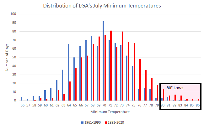
LaGuardia Airport had a low temperature of 80° this morning. The number of such minimum temperatures has increased dramatically in recent years, both annually and during July. During 1961-1990, there were 10 low temperatures of 80° or above. During 1991-2020, there were 38 such temperatures. Low temperatures below 60° have become rare. During 1961-1990 there were 16 such days. During 1991-2020, there were 4. Overall, the average July low temperature at LaGuardia Airport has increased from 68.9° during 1961-1990 to 71.4° during 1991-2020. The July distribution of low temperatures is below:
-
Hottest Weather So Far Lies Ahead for Phoenix
donsutherland1 replied to donsutherland1's topic in Central/Western States
Yesterday, Phoenix had a low temperature of 94. That tied the daily record from 2010 and was just the 12th 94 or above low temperature in July (16th overall). Such outcomes have increased in Phoenix's warmer climate (Mean July lows: 1961-1990: 81.0F; 1991-2020: 84.2F). The distribution of Phoenix’s July low temperatures is below (1961-1990 vs. 1991-2020).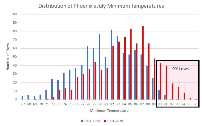
-
Morning thoughts… It will be mostly sunny and hot. High temperatures will reach the lower and middle 90s in most of the region. Likely high temperatures around the region include: New York City (Central Park): 93° Newark: 100° Philadelphia: 97° Hot weather will continue through at least the weekend. Normals: New York City: 30-Year: 85.3°; 15-Year: 86.4° Newark: 30-Year: 87.2°; 15-Year: 88.5° Philadelphia: 30-Year: 88.0°; 15-Year: 89.1°
-
The longest heatwave so far this summer is developing. The hottest temperatures will likely be west of New York City in adjacent New Jersey where temperatures could peak in the upper 90s and perhaps reach or exceed 100° at the height of the heatwave. During June 16-20, the MJO has been in Phase 1 at an amplitude of 1.500 or above. Of the six cases that saw such an outcome during June 15-25 (1988, 2003, 2010, 2012, 2017 and 2020), four had a warmer than normal July, one was somewhat cooler than normal and one was cooler than normal. The latest guidance all indicates that July will wind up solidly among the warmer than normal cases. The ECMWF seasonal forecast indicates that the summer will be warmer than normal throughout the region and across much of North America. Based on how the pattern has been evolving during the spring transition to summer, it is more likely than not that the warmest anomalies of the summer will likely occur in July and August with June being the coolest of the three months in the Northeast. The latest ECMWF monthly forecast indicates that July will be warmer than June relative to normal and that August will be the warmest summer month relative to normal. In addition, in the 6 past cases when the June AO averaged +0.750 or above (1950-2021), 50% of the following July cases were warmer than normal. 67% of the following August and September cases featured above normal temperatures. The ENSO Region 1+2 anomaly was -1.2°C and the Region 3.4 anomaly was -0.6°C for the week centered around July 13. For the past six weeks, the ENSO Region 1+2 anomaly has averaged -1.40°C and the ENSO Region 3.4 anomaly has averaged -0.60°C. La Niña conditions will likely persist through the summer. The SOI was -0.43. The SOI was negative for the third consecutive day. The last time that happened was February 13-16, 2022 when the SOI was negative for four consecutive days. The preliminary Arctic Oscillation (AO) was -0.621 today. On July 17 the MJO was in Phase 4 at an amplitude of 0.734 (RMM). The July 16-adjusted amplitude was 0.960 (RMM). Based on sensitivity analysis applied to the latest guidance, there is an implied 90% probability that New York City will have a warmer than normal July (1991-2020 normal). July will likely finish with a mean temperature near 79.8° (2.3° above normal).
-
Texas/Oklahoma Discussion & Obs Thread 2022
donsutherland1 replied to It's Always Sunny's topic in Central/Western States
San Antonio reached 100 degrees for the 40th time this year. The old record through July 19th was 27 days in 2009. Only 2009, 2011 and 2013 had 40 or more days for a whole year. The increasing frequency of 100-degree days is the result of warming summers.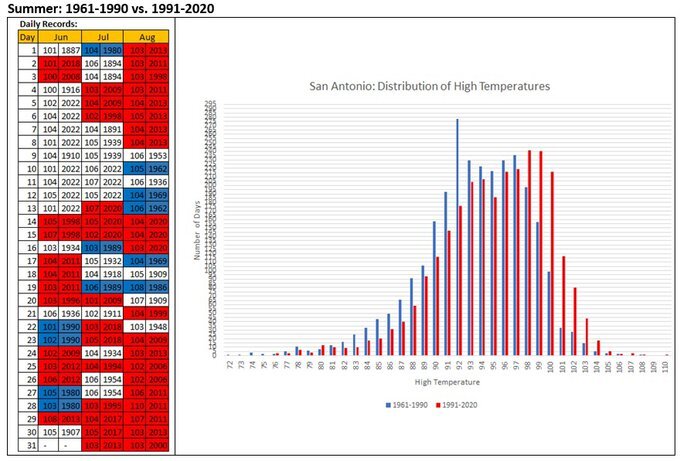
-
UK Met Office Forecasts 40C for the First Time
donsutherland1 replied to donsutherland1's topic in Climate Change
Also, this attribution study from the July 2019 heatwave in Europe is very likely representative. A key finding: It is noteworthy that every heatwave analysed so far in Europe in recent years (2003, 2010, 2015, 2017, 2018, June 2019 and this study) was found to be made much more likely and more intense due to human-induced climate change. How much more depends very strongly on the event definition: location, season, intensity and durations. The July 2019 heatwave was so extreme over continental Western Europe that the observed magnitudes would have been extremely unlikely without climate change. https://www.worldweatherattribution.org/wp-content/uploads/July2019heatwave.pdf -
UK Met Office Forecasts 40C for the First Time
donsutherland1 replied to donsutherland1's topic in Climate Change
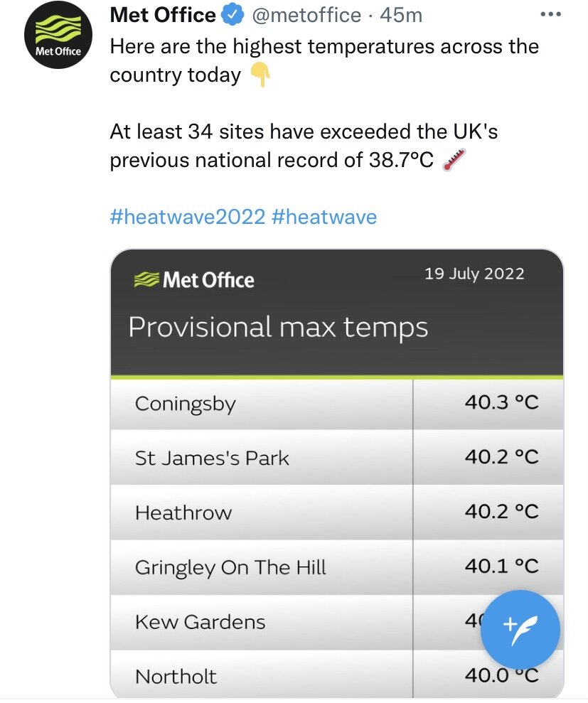
A historic day: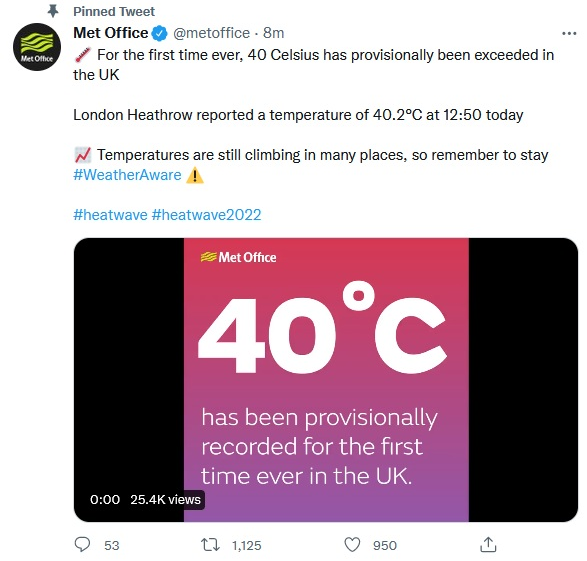

-
UK Met Office Forecasts 40C for the First Time
donsutherland1 replied to donsutherland1's topic in Climate Change
39.1C at Charlwood Surrey. https://twitter.com/metoffice/status/1549345259016142848?s=20&t=G3wOdvxQETuxLdmQiwP-2A -
Morning thoughts… It will be mostly sunny and hot. High temperatures will reach the lower and middle 90s in most of the region. Likely high temperatures around the region include: New York City (Central Park): 92° Newark: 97° Philadelphia: 94° Hot weather will continue through at least the weekend. Normals: New York City: 30-Year: 85.3°; 15-Year: 86.4° Newark: 30-Year: 87.2°; 15-Year: 88.6° Philadelphia: 30-Year: 88.1°; 15-Year: 89.1°
-
With 1.85” of rain through 7:08 on EDT, Central Park has surpassed its daily record rainfall of 1.76” from 2012.
-
Showers and thunderstorms, some of which could be heavy, will continue through at least the first half of tonight. Additional flooding is possible in parts of New Jersey and southeastern New York State. Afterward, another spell of heat will develop. The potential exists for the longest heatwave so far this summer. The hottest temperatures will likely be west of New York City in adjacent New Jersey where temperatures could peak in the upper 90s and perhaps reach 100° at the height of the heatwave. The temperature reached 99° at London's Heathrow Airport today and 101° at Standon Downham. Jersey reached 100° for the first time on record. The national UK record will likely be broken tomorrow. The possibility exists that the UK could see its first 40°C (104°F) temperature on record. In France, Biscarosse reached a scorching 109°. Overall, 25 locations set new all-time high temperature records. During June 16-20, the MJO has been in Phase 1 at an amplitude of 1.500 or above. Of the six cases that saw such an outcome during June 15-25 (1988, 2003, 2010, 2012, 2017 and 2020), four had a warmer than normal July, one was somewhat cooler than normal and one was cooler than normal. The latest guidance all indicates that July will wind up among the warmer than normal cases. The ECMWF seasonal forecast indicates that the summer will be warmer than normal throughout the region and across much of North America. Based on how the pattern has been evolving during the spring transition to summer, it is more likely than not that the warmest anomalies of the summer will likely occur in July and August with June being the coolest of the three months in the Northeast. The latest ECMWF monthly forecast indicates that July will be warmer than June relative to normal and that August will be the warmest summer month relative to normal. In addition, in the 6 past cases when the June AO averaged +0.750 or above (1950-2021), 50% of the following July cases were warmer than normal. 67% of the following August and September cases featured above normal temperatures. The ENSO Region 1+2 anomaly was -1.2°C and the Region 3.4 anomaly was -0.6°C for the week centered around July 13. For the past six weeks, the ENSO Region 1+2 anomaly has averaged -1.40°C and the ENSO Region 3.4 anomaly has averaged -0.60°C. La Niña conditions will likely persist through the summer. The SOI was -6.40. The preliminary Arctic Oscillation (AO) was -0.035 today. On July 16 the MJO was in Phase 4 at an amplitude of 0.962 (RMM). The July 15-adjusted amplitude was 0.987 (RMM). Based on sensitivity analysis applied to the latest guidance, there is an implied 86% probability that New York City will have a warmer than normal July (1991-2020 normal). July will likely finish with a mean temperature near 79.6° (2.1° above normal).
-
UK Met Office Forecasts 40C for the First Time
donsutherland1 replied to donsutherland1's topic in Climate Change
The air base at Brize Norton also suffered infrastructure damage from the heat. -
UK Met Office Forecasts 40C for the First Time
donsutherland1 replied to donsutherland1's topic in Climate Change
A great link for monitoring the heat in the UK is https://wow.metoffice.gov.uk/ -
Morning thoughts… It will be variably cloudy and warm. Showers and thundershowers are likely. Some of thunderstorms could be severe. High temperatures will reach the lower and middle 80s in most of the region. Likely high temperatures around the region include: New York City (Central Park): 85° Newark: 90° Philadelphia: 91° Hot weather will arrive tomorrow and continue through at least the weekend. Normals: New York City: 30-Year: 85.3°; 15-Year: 86.4° Newark: 30-Year: 87.2°; 15-Year: 88.6° Philadelphia: 30-Year: 88.1°; 15-Year: 89.2°
-
Record dewpoints were also reported in Manitoba, including Winnipeg.
-
Showers and thunderstorms, some of which could be heavy, are likely tonight through tomorrow. Afterward, another spell of heat will develop. The potential exists for the longest heatwave so far this summer. The hottest temperatures will likely be west of New York City in adjacent New Jersey where temperatures could peak in the upper 90s and perhaps reach 100° at the height of the heatwave. Across the Atlantic, the extreme heat that has continued to topple daily, monthly and some all-time records in parts of Andorra, France, Spain, and Italy will spread into the United Kingdom. Already, Hawarden reached 91° and London (Heathrow Airport) hit 87° today. The national UK record could be challenged or broken tomorrow and/or Tuesday. The possibility exists that the UK could see its first 40°C (104°F) temperature on record. During June 16-20, the MJO has been in Phase 1 at an amplitude of 1.500 or above. Of the six cases that saw such an outcome during June 15-25 (1988, 2003, 2010, 2012, 2017 and 2020), four had a warmer than normal July, one was somewhat cooler than normal and one was cooler than normal. The latest guidance all indicates that July will wind up among the warmer than normal cases. The ECMWF seasonal forecast indicates that the summer will be warmer than normal throughout the region and across much of North America. Based on how the pattern has been evolving during the spring transition to summer, it is more likely than not that the warmest anomalies of the summer will likely occur in July and August with June being the coolest of the three months in the Northeast. The latest ECMWF monthly forecast indicates that July will be warmer than June relative to normal and that August will be the warmest summer month relative to normal. In addition, in the 6 past cases when the June AO averaged +0.750 or above (1950-2021), 50% of the following July cases were warmer than normal. 67% of the following August and September cases featured above normal temperatures. The ENSO Region 1+2 anomaly was -1.2°C and the Region 3.4 anomaly was -0.5°C for the week centered around July 6. For the past six weeks, the ENSO Region 1+2 anomaly has averaged -1.30°C and the ENSO Region 3.4 anomaly has averaged -0.65°C. La Niña conditions will likely persist through the summer. The SOI was -2.77. The preliminary Arctic Oscillation (AO) was +0.136 today. On July 15 the MJO was in Phase 4 at an amplitude of 0.987 (RMM). The July 14-adjusted amplitude was 1.057 (RMM). Based on sensitivity analysis applied to the latest guidance, there is an implied 82% probability that New York City will have a warmer than normal July (1991-2020 normal). July will likely finish with a mean temperature near 79.5° (2.0° above normal).
-
Morning thoughts… It will be variably cloudy and warm. Showers and thundershowers are possible. High temperatures will reach the lower and middle 80s in most of the region. Likely high temperatures around the region include: New York City (Central Park): 84° Newark: 89° Philadelphia: 87° Tomorrow will see showers and thunderstorms, some of which can be heavy. Afterward, heat will return to the region. Normals: New York City: 30-Year: 85.3°; 15-Year: 86.4° Newark: 30-Year: 87.3°; 15-Year: 88.6° Philadelphia: 30-Year: 88.1°; 15-Year: 89.2°
-
During the most recent hour, Washington, DC's Reagan National Airport picked up 1.09" of rain. That was the fourth such hourly amount this year. Both 2020 and 2021 had three hours with rainfall amounts of 1.00" or more. The last time there were four such hourly amounts was in 1970. The record of six hourly amounts was set in 1952. Earlier today, New York City also picked up hourly rainfall of 1.00" or more. The last time both cities saw such rainfall amounts on the same date was July 17, 2018. Hourly data goes back to 1948.
-
A small but intense thunderstorm dumped 1.10" of rain on New York City this afternoon with 1.02" falling within an hour. That was this year's first hourly rainfall of 1.00" or more. During 1889-1999, New York City saw one such rainfall about once every 26.1 months. Since 2000, New York City has experienced such a rainfall once every 8.9 months. July accounts for 30% of such cases. August is second with 22% of such cases. Tomorrow will be a similar day. It will be variably cloudy and warm. Showers and thundershowers are possible. Another spell of heat is likely starting early next week. The potential exists for the longest heatwave so far this summer. Across the Atlantic, the extreme heat that has continued to topple daily, monthly and some all-time records in parts of Andorra, France, Spain, and Italy will spread into the United Kingdom. The national UK record could be challenged or broken on Monday and/or Tuesday. The possibility exists that the UK could see its first 40°C (104°F) temperature on record. During June 16-20, the MJO has been in Phase 1 at an amplitude of 1.500 or above. Of the six cases that saw such an outcome during June 15-25 (1988, 2003, 2010, 2012, 2017 and 2020), four had a warmer than normal July, one was somewhat cooler than normal and one was cooler than normal. The latest guidance all indicates that July will wind up among the warmer than normal cases. The ECMWF seasonal forecast indicates that the summer will be warmer than normal throughout the region and across much of North America. Based on how the pattern has been evolving during the spring transition to summer, it is more likely than not that the warmest anomalies of the summer will likely occur in July and August with June being the coolest of the three months in the Northeast. The latest ECMWF monthly forecast indicates that July will be warmer than June relative to normal and that August will be the warmest summer month relative to normal. In addition, in the 6 past cases when the June AO averaged +0.750 or above (1950-2021), 50% of the following July cases were warmer than normal. 67% of the following August and September cases featured above normal temperatures. The ENSO Region 1+2 anomaly was -1.2°C and the Region 3.4 anomaly was -0.5°C for the week centered around July 6. For the past six weeks, the ENSO Region 1+2 anomaly has averaged -1.30°C and the ENSO Region 3.4 anomaly has averaged -0.65°C. La Niña conditions will likely persist through the summer. The SOI was +3.32. The preliminary Arctic Oscillation (AO) was +0.226 today. On July 14 the MJO was in Phase 4 at an amplitude of 1.054 (RMM). The July 13-adjusted amplitude was 0.778 (RMM). Based on sensitivity analysis applied to the latest guidance, there is an implied 79% probability that New York City will have a warmer than normal July (1991-2020 normal). July will likely finish with a mean temperature near 79.3° (1.8° above normal).
-
New York City (Central Park) has picked up 1.02" of rain so far this hour. The last time that happened was September 1, 2021 during the Ida-related floods. July accounts for 30% of New York City's 1" or above hourly rainfalls.
-
Occasional Thoughts on Climate Change
donsutherland1 replied to donsutherland1's topic in Climate Change
With potential record heat likely in the UK, the climate change denial community is desperately seeking to deflect from the reality of the outcome. https://twitter.com/BigJoeBastardi/status/1548120815962427392?s=20&t=ry37eyHIu5gGsAIXiSGx1Q In fact, climate scientists forecast that the kind of heat that will descend on the UK will be increasingly likely. https://www.nature.com/articles/s41467-020-16834-0 No such forecast was made by those trying to weaponize forecasts against climate scientists. -
Morning thoughts… It will be variably cloudy and somewhat cooler. Some showers and thundershowers are possible. High temperatures will reach the lower and middle 80s in most of the region. Likely high temperatures around the region include: New York City (Central Park): 83° Newark: 88° Philadelphia: 87° More heat could return to the region early next week. Normals: New York City: 30-Year: 85.2°; 15-Year: 86.3° Newark: 30-Year: 87.3°; 15-Year: 88.5° Philadelphia: 30-Year: 88.1°; 15-Year: 89.2°
-
Temperatures will continue to average near or above normal through at least the weekend. Another spell of heat is possible next week. Before then some rain is possible from scattered thunderstorms from Sunday night into Tuesday. Across the Atlantic, the extreme heat that was been toppling daily, monthly and some all-time records in parts of France, Spain, and Italy will spread into the United Kingdom. The national UK record could be challenged or broken on Monday and/or Tuesday. The possibility exists that the UK could see its first 40°C (104°F) temperature on record. During June 16-20, the MJO has been in Phase 1 at an amplitude of 1.500 or above. Of the six cases that saw such an outcome during June 15-25 (1988, 2003, 2010, 2012, 2017 and 2020), four had a warmer than normal July, one was somewhat cooler than normal and one was cooler than normal. The latest guidance all indicates that July will wind up among the warmer than normal cases. The ECMWF seasonal forecast indicates that the summer will be warmer than normal throughout the region and across much of North America. Based on how the pattern has been evolving during the spring transition to summer, it is more likely than not that the warmest anomalies of the summer will likely occur in July and August with June being the coolest of the three months in the Northeast. The latest ECMWF monthly forecast indicates that July will be warmer than June relative to normal and that August will be the warmest summer month relative to normal. In addition, in the 6 past cases when the June AO averaged +0.750 or above (1950-2021), 50% of the following July cases were warmer than normal. 67% of the following August and September cases featured above normal temperatures. The ENSO Region 1+2 anomaly was -1.2°C and the Region 3.4 anomaly was -0.5°C for the week centered around July 6. For the past six weeks, the ENSO Region 1+2 anomaly has averaged -1.30°C and the ENSO Region 3.4 anomaly has averaged -0.65°C. La Niña conditions will likely persist through the summer. The SOI was +6.77. The preliminary Arctic Oscillation (AO) was +0.067 today. On July 13 the MJO was in Phase 4 at an amplitude of 0.777 (RMM). The July 12-adjusted amplitude was 0.527 (RMM). Based on sensitivity analysis applied to the latest guidance, there is an implied 75% probability that New York City will have a warmer than normal July (1991-2020 normal). July will likely finish with a mean temperature near 79.1° (1.6° above normal).
-
UK Met Office Forecasts 40C for the First Time
donsutherland1 replied to donsutherland1's topic in Climate Change
It reveals that those blogging there have no understanding of climate or climate change. -
Hottest Weather So Far Lies Ahead for Phoenix
donsutherland1 replied to donsutherland1's topic in Central/Western States
Through the first two weeks of July, Phoenix has a summer mean temperature of 95.6°. That ranks as the 4th hottest temperature on record for the period from June 1 through July 14 going back to 1896. For all of summer, 11/12 (92%) of summers with a mean temperature of 94.5° or above have occurred since 2000 and half have occurred since 2010. Five of the last seven summers met or exceeded the 94.5° average.