

donsutherland1
-
Posts
23,768 -
Joined
Content Type
Profiles
Blogs
Forums
American Weather
Media Demo
Store
Gallery
Everything posted by donsutherland1
-
Congratulations. Nice article and photo.
-
New York City had a monthly mean temperature of 50.9° in November. That was 2.9° above normal. December could start mild overall. With the development of an EPO-/AO-/PNA- pattern, colder air intrusions could become more frequent after the first week of December. The potential for snowfall could also begin to increase. The latest guidance suggests that the AO could fall to -3.000 or below during the second week of December. Since 1950, there were 24 cases that saw the AO reach -3.000 or below during December. Mean snowfall for those cases was 6.2" (Median: 6.0"). 50% of such cases saw December wind up with 6.0" or more snow (25% saw 10.0" or more). In contrast, during all other December cases, mean December snowfall was 3.5" (Median: 2.5"). In those cases, 21% of years saw December snowfall of 6.0" or more while 8% saw 10.0" or more snowfall. The ENSO Region 1+2 anomaly was -1.7°C and the Region 3.4 anomaly was -0.8°C for the week centered around November 23. For the past six weeks, the ENSO Region 1+2 anomaly has averaged -1.57°C and the ENSO Region 3.4 anomaly has averaged -0.92°C. La Niña conditions will likely persist through mid-winter. The SOI was +27.80 today. The preliminary Arctic Oscillation (AO) was -1.836 today. On November 28 the MJO was in Phase 7 at an amplitude of 1.594 (RMM). The November 27-adjusted amplitude was 1.744 (RMM).
-
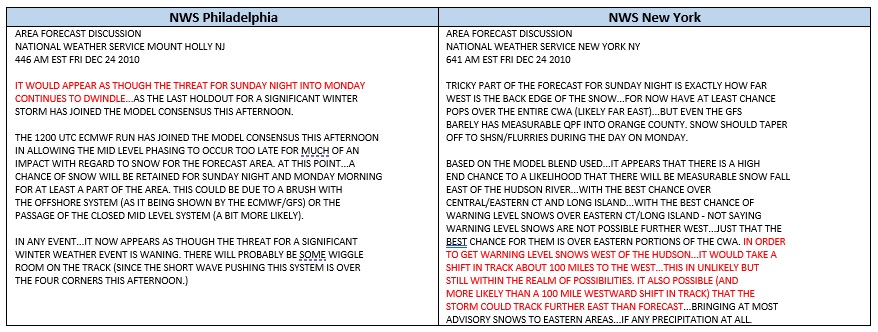
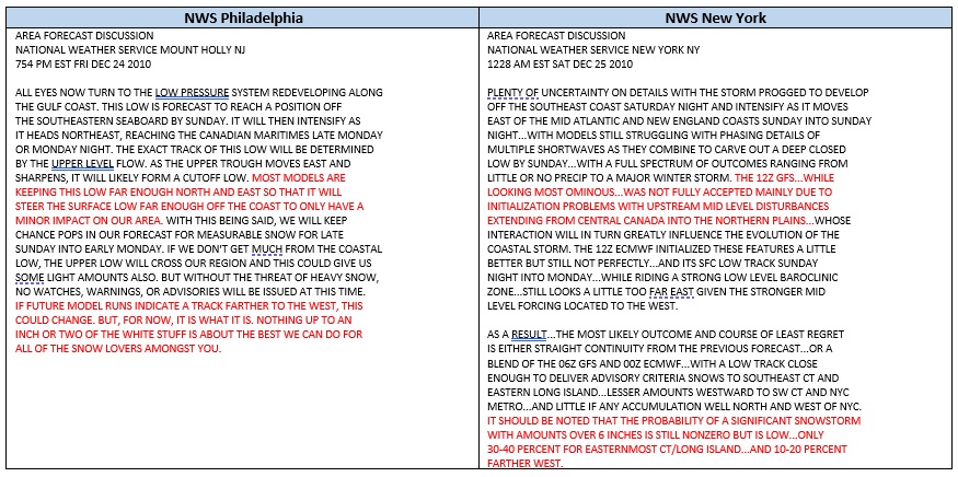
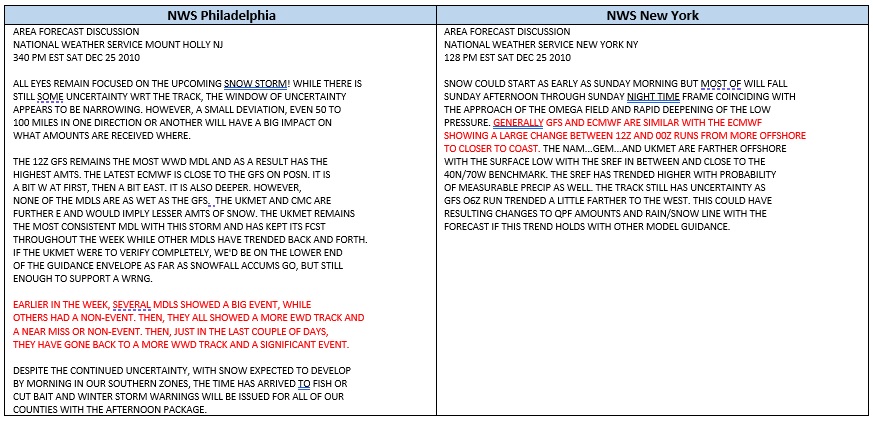
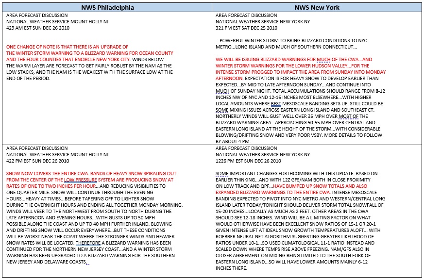
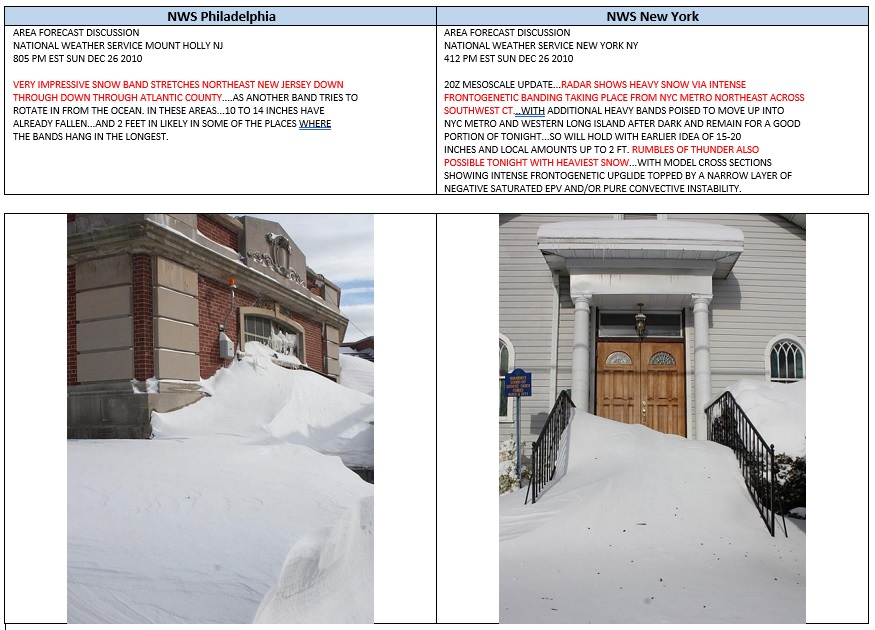
While we await the pattern change to a potentially snowy pattern, one unforgettable past storm was the Boxing Day Blizzard of 2010. Until close to the event, many models showed only a minor event. Things changed rapidly, as detailed in snippets from NWS area forecast discussions. By the time the snow ended, snowfall totals included: Atlantic City: 19.0" Bricktown, NJ: 30.0" Butler, NJ: 22.0" Drifts to four feet Elizabeth, NJ: 31.8" Harriman, NY: 26.0" Islip: 14.2" Jersey City: 26.0" Lincoln Park, NJ: 29.0" Drifts over three feet Lyndhurst, NJ: 29.0" New York City: 20.0" Newark: 24.2" North Massapequa, NY: 23.5" Philadelphia: 12.4" Rahway, NJ: 32.0" Upton, NY: 18.8"
-
I agree. If the pattern evolves as forecast, there will be a lot of potential. I'm looking forward to it.
-
For reference as the hemispheric pattern continues to evolve toward a very blocky pattern.
-
DCA _ NYC _ BOS ___ ORD _ ATL _ IAH ____ DEN _ PHX _ SEA -0.8 -1.0 -0.8 -4.3 0.8 1.0 0.5 0.8 -4.2 DCA _ NYC _ BOS ___ ORD _ DTW _ BUF ___ DEN _ SEA _ BTV 10.0 36.0 55.0 45.8 52.5 95.0 44.0 7.0 100.0
-
Morning thoughts… Rain will overspread the region this morning. A general 0.25”-0.75” rainfall with locally higher amounts is likely. It will also become windy with gusts reaching or exceeding 40 mph. High temperatures will reach the middle and upper 50s in most of the region. Likely high temperatures around the region include: New York City (Central Park): 58° Newark: 60° Philadelphia: 60° Tomorrow will be blustery and cooler. Normals: New York City: 30-Year: 49.0°; 15-Year: 49.4° Newark: 30-Year: 49.6°; 15-Year: 50.1° Philadelphia: 30-Year: 50.6°; 15-Year: 51.2°
-
Clouds will increase overnight. During the pre-dawn hours, the temperature will begin to rise. Rain will then overspread the region during the morning. Some of the rain could be briefly heavy. The temperature will top out in the upper 50s to perhaps 60° in parts of the region. New York City is all but certain to see a November mean temperature of 50° or above for the 21st time and second time in the last three years. A disproportionate share of 50° or warmer November cases has occurred since 2000. Records go back to 1869. December could start mild, though it will be noticeably cooler than tomorrow. With the development of an EPO-/AO-/PNA- pattern, colder air intrusions could become more frequent after the first week of December. The latest EPS suggests that the AO could fall to -3.000 or below during the second week of December. Since 1950, there were 24 cases that saw the AO reach -3.000 or below during December. Mean snowfall for those cases was 6.2" (Median: 6.0"). 50% of such cases saw December wind up with 6.0" or more snow (25% saw 10.0" or more). In contrast, during all other December cases, mean December snowfall was 3.5" (Median: 2.5"). In those cases, 21% of years saw December snowfall of 6.0" or more while 8% saw 10.0" or more snowfall. The ENSO Region 1+2 anomaly was -1.7°C and the Region 3.4 anomaly was -0.8°C for the week centered around November 23. For the past six weeks, the ENSO Region 1+2 anomaly has averaged -1.57°C and the ENSO Region 3.4 anomaly has averaged -0.92°C. La Niña conditions will likely persist through mid-winter. The SOI was +27.80 today. The preliminary Arctic Oscillation (AO) was -1.932 today. On November 27 the MJO was in Phase 7 at an amplitude of 1.745 (RMM). The November 26-adjusted amplitude was 1.826 (RMM). Based on sensitivity analysis applied to the latest guidance, there is an implied near 100% probability that New York City will have a warmer than normal November (1991-2020 normal). November will likely finish with a mean temperature near 50.9° (2.9° above normal).
-
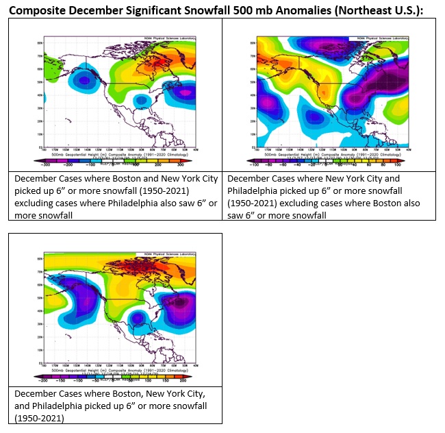
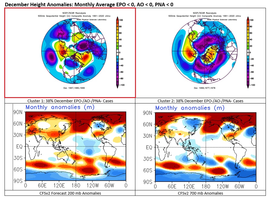
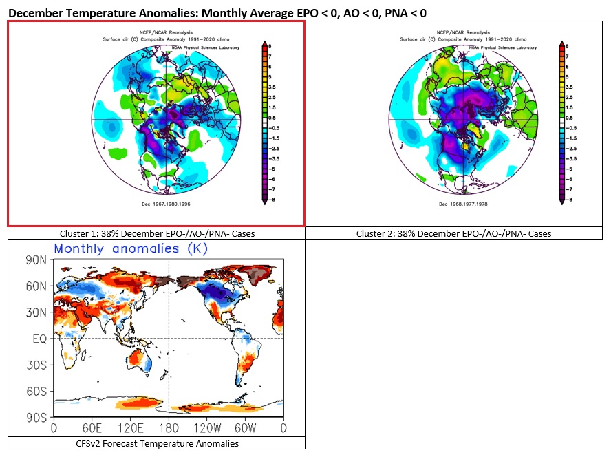
With an EPO-/AO-/PNA- pattern forecast to predominate during at least the first 1-2 weeks of December, the guidance has evolved toward a higher probability of cold anomalies in eastern North America. There are two clusters of monthly outcomes (1950-2021) when the EPO, AO, and PNA all averaged < 0 during December. Those two clusters account for 75% of December EPO-/AO-/PNA- cases. The CFSv2 currently favors the first idea. The second would feature even more widespread cold in the CONUS. Both scenarios feature widespread cold in Europe. It should be noted that teleconnection forecasts lose skill after 10-14 days.
-
Morning thoughts… Today will be partly sunny and cool. High temperatures will reach the middle and upper 40s in most of the region. Likely high temperatures around the region include: New York City (Central Park): 45° Newark: 48° Philadelphia: 49° Temperatures will rebound tomorrow, but rain is likely. Normals: New York City: 30-Year: 49.4°; 15-Year: 49.7° Newark: 30-Year: 50.0°; 15-Year: 50.4° Philadelphia: 30-Year: 51.0°; 15-Year: 51.5°
-
I'm increasingly optimistic about the forecast blocking and snowfall potential. Keep in mind that there are some adverse risks. Consider December 1958 and winter 1958-59 as an example. But those have been the exception, not the rule.
-
Tomorrow will be cool day. However, temperatures will rebound during the middle of the week. New York City will very likely see a November mean temperature of 50° or above for the 21st time and second time in the last three years. A disproportionate share of 50° or warmer November cases has occurred since 2000. Records go back to 1869. December could start mild. However, with the development of an EPO-/AO-/PNA- pattern, colder air intrusions could become more frequent after the first week of December, should the teleconnection forecast verify and the most common clusters of 500 mb patterns (75% of such cases) develop. The latest EPS suggests that the AO could fall to -3.000 or below during the second week of December. Since 1950, there were 24 cases that saw the AO reach -3.000 or below during December. Mean snowfall for those cases was 6.2" (Median: 6.0"). 50% of such cases saw December wind up with 6.0" or more snow (25% saw 10.0" or more). In contrast, during all other December cases, mean December snowfall was 3.5" (Median: 2.5"). In those cases, 21% of years saw December snowfall of 6.0" or more while 8% saw 10.0" or more snowfall. The ENSO Region 1+2 anomaly was -1.7°C and the Region 3.4 anomaly was -0.8°C for the week centered around November 23. For the past six weeks, the ENSO Region 1+2 anomaly has averaged -1.57°C and the ENSO Region 3.4 anomaly has averaged -0.92°C. La Niña conditions will likely persist through mid-winter. The SOI was +23.28 today. The preliminary Arctic Oscillation (AO) was -1.425 today. On November 26 the MJO was in Phase 7 at an amplitude of 1.826 (RMM). The November 25-adjusted amplitude was 1.631 (RMM). Based on sensitivity analysis applied to the latest guidance, there is an implied near 100% probability that New York City will have a warmer than normal November (1991-2020 normal). November will likely finish with a mean temperature near 50.9° (2.9° above normal).
-
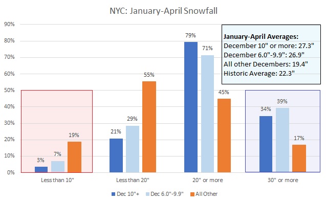
Here's a graph for New York City's historic December data (1869-2021):
-
Morning thoughts… Today will be partly sunny and breezy. Temperatures will likely fall during the afternoon. High temperatures will reach the lower and middle 50s in most of the region. Likely high temperatures around the region include: New York City (Central Park): 53° Newark: 55° Philadelphia: 54° It will turn cooler for tomorrow and Tuesday before temperatures rebound. Normals: New York City: 30-Year: 49.7°; 15-Year: 50.0° Newark: 30-Year: 50.3°; 15-Year: 50.7° Philadelphia: 30-Year: 51.3°; 15-Year: 51.8°
-
Yes. Those with 10" or more do even better.
-
A few additional showers are likely through midnight. Temperatures will remain will be unseasonably mild overnight. Cooler air will overspread the region tomorrow, but temperatures could rebound during the middle of the week. New York City will very likely see a November mean temperature of 50° or above for the 21st time and second time in the last three years. A disproportionate share of 50° or warmer November cases has occurred since 2000. Records go back to 1869. December could start mild. However, with the development of an EPO-/AO-/PNA- pattern, colder air intrusions could become more frequent after the first week of December, should the teleconnection forecast verify and the most common clusters of 500 mb patterns (75% of such cases) develop. The latest EPS suggests that the AO could fall to -3.000 or below during the second week of December. Since 1950, there were 24 cases that saw the AO reach -3.000 or below during December. Mean snowfall for those cases was 6.2" (Median: 6.0"). 50% of such cases saw December wind up with 6.0" or more snow (25% saw 10.0" or more). In contrast, during all other December cases, mean December snowfall ws 3.5" (Median: 2.5"). In those cases, 21% of years saw December snowfall of 6.0" or more while 8% saw 10.0" or more snowfall. The ENSO Region 1+2 anomaly was -1.3°C and the Region 3.4 anomaly was -0.8°C for the week centered around November 16. For the past six weeks, the ENSO Region 1+2 anomaly has averaged -1.62°C and the ENSO Region 3.4 anomaly has averaged -0.92°C. La Niña conditions will likely persist into the winter. The SOI was +10.02 today. The preliminary Arctic Oscillation (AO) was -0.533 today. On November 25 the MJO was in Phase 7 at an amplitude of 1.630 (RMM). The November 24-adjusted amplitude was 1.318 (RMM). Based on sensitivity analysis applied to the latest guidance, there is an implied near 100% probability that New York City will have a warmer than normal November (1991-2020 normal). November will likely finish with a mean temperature near 50.8° (2.8° above normal).
-
Morning thoughts… Rain will arrive late this morning or early this afternoon. It will be another mild day. High temperatures will reach the middle and upper 50s in most of the region. Likely high temperatures around the region include: New York City (Central Park): 57° Newark: 59° Philadelphia: 60° It will turn cooler for tomorrow and Tuesday before temperatures rebound. Normals: New York City: 30-Year: 50.0°; 15-Year: 50.3° Newark: 30-Year: 50.7°; 15-Year: 51.1° Philadelphia: 30-Year: 51.7°; 15-Year: 52.1°
-
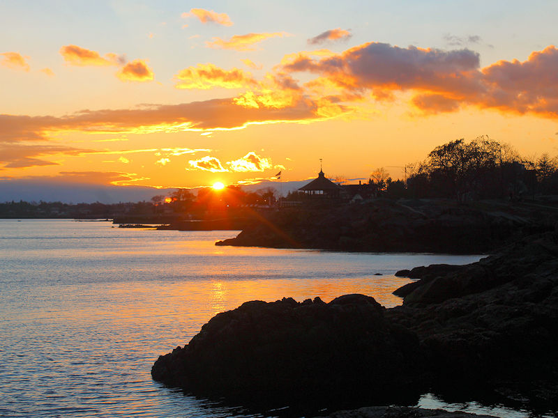
Sunrise ahead of today’s approaching rain.


-
Under bright sunshine, the temperature again rose into the middle and upper 50s across the region. Newark reached 60°. Down South, Miami reached 87° for the 11th time this month. That tied the November record, which was set in 1986 and tied in 2015. Rain will return to the region tomorrow into Monday. Most of the region will see 0.25"-0.75" of rain. There could be some locally higher amounts. Temperatures will remain generally mild. Overall, temperatures will generally be near to above normal through the remainder of November. New York City will very likely see a November mean temperature of 50° or above for the 21st time and second time in the last three years. A disproportionate share of 50° or warmer November cases has occurred since 2000. Records go back to 1869. December could start mild. However, with the development of an EPO-/AO-/PNA- pattern, colder air intrusions could become more frequent after the first week of December, should the teleconnection forecast verify and the most common clusters of 500 mb patterns (75% of such cases) develop. The ENSO Region 1+2 anomaly was -1.3°C and the Region 3.4 anomaly was -0.8°C for the week centered around November 16. For the past six weeks, the ENSO Region 1+2 anomaly has averaged -1.62°C and the ENSO Region 3.4 anomaly has averaged -0.92°C. La Niña conditions will likely persist into the winter. The SOI was -4.27 today. The preliminary Arctic Oscillation (AO) was -0.241 today. On November 24 the MJO was in Phase 7 at an amplitude of 1.316 (RMM). The November 23-adjusted amplitude was 1.246 (RMM). Based on sensitivity analysis applied to the latest guidance, there is an implied near 100% probability that New York City will have a warmer than normal November (1991-2020 normal). November will likely finish with a mean temperature near 50.8° (2.8° above normal).
-
After a sunny start to the weekend, rain will return to the region Sunday into Monday. Temperatures will remain generally mild. Overall, temperatures will generally be near to above normal through the remainder of November. New York City will very likely see a November mean temperature of 50° or above for the 21st time and second time in the last three years. A disproportionate share of 50° or warmer November cases has occurred since 2000. Records go back to 1869. December could start mild. However, with the development of an EPO-/AO-/PNA- pattern, colder air intrusions could become more frequent after the first week of December, should the teleconnection forecast verify and the most common clusters of 500 mb patterns (75% of such cases) develop. The ENSO Region 1+2 anomaly was -1.3°C and the Region 3.4 anomaly was -0.8°C for the week centered around November 16. For the past six weeks, the ENSO Region 1+2 anomaly has averaged -1.62°C and the ENSO Region 3.4 anomaly has averaged -0.92°C. La Niña conditions will likely persist into the winter. The SOI was +1.97 today. The preliminary Arctic Oscillation (AO) was -0.738 today. On November 23 the MJO was in Phase 6 at an amplitude of 1.243 (RMM). The November 22-adjusted amplitude was 1.252 (RMM). Based on sensitivity analysis applied to the latest guidance, there is an implied near 100% probability that New York City will have a warmer than normal November (1991-2020 normal). November will likely finish with a mean temperature near 50.6° (2.6° above normal).
-
Near sunset to conclude another mild November day.
-
Morning thoughts… Clouds and showers will give way to partly sunny skies this afternoon. High temperatures will reach the lower and middle 50s in most of the region. Likely high temperatures around the region include: New York City (Central Park): 52° Newark: 55° Philadelphia: 56° The remainder of November will be generally milder than normal. Normals: New York City: 30-Year: 50.7°; 15-Year: 50.9° Newark: 30-Year: 51.4°; 15-Year: 51.8° Philadelphia: 30-Year: 52.4°; 15-Year: 52.7°
-
Tomorrow will be variably cloudy and mild. There could be a few showers. The weekend could see additional rainfall, along with continued mild readings. Overall, temperatures will generally be near to above normal through the remainder of November. New York City will very likely see a November mean temperature of 50° or above for the 21st time and second time in the last three years. A disproportionate share of 50° or warmer November cases has occurred since 2000. Records go back to 1869. December could start mild. However, with the development of an EPO-/AO-/PNA- pattern, colder air intrusions could become more frequent after the first week of December, should the teleconnection forecast verify and the most common clusters of 500 mb patterns (75% of such cases) develop. The ENSO Region 1+2 anomaly was -1.3°C and the Region 3.4 anomaly was -0.8°C for the week centered around November 16. For the past six weeks, the ENSO Region 1+2 anomaly has averaged -1.62°C and the ENSO Region 3.4 anomaly has averaged -0.92°C. La Niña conditions will likely persist into the winter. The SOI was +11.39 today. The preliminary Arctic Oscillation (AO) was -0.598 today. On November 22 the MJO was in Phase 6 at an amplitude of 1.248 (RMM). The November 21-adjusted amplitude was 1.165 (RMM). Based on sensitivity analysis applied to the latest guidance, there is an implied 99% probability that New York City will have a warmer than normal November (1991-2020 normal). November will likely finish with a mean temperature near 50.4° (2.4° above normal).
-
51 degrees and bright sunshine. If only they knew what is happening today…
-
Morning thoughts… Today will be partly sunny and mild. High temperatures will reach the lower and middle 50s in most of the region. Likely high temperatures around the region include: New York City (Central Park): 53° Newark: 56° Philadelphia: 58° The remainder of November will be generally milder than normal. Normals: New York City: 30-Year: 51.1°; 15-Year: 51.3° Newark: 30-Year: 51.8°; 15-Year: 52.1° Philadelphia: 30-Year: 52.8°; 15-Year: 53.1°


