donsutherland1
-
Posts
23,765 -
Joined
Content Type
Profiles
Blogs
Forums
American Weather
Media Demo
Store
Gallery
Everything posted by donsutherland1
-
Showers and periods of rain are now overspreading the region. Light rain is falling in parts of the New York City area. Wilmington, DE has seen its first measurable rainfall since September 28th. Periods of rain are likely overnight into tomorrow. A general 0.25"-0.50" rainfall is likely. A few showers will be possible on Thursday as a warm front moves across the region. A strong cold shot is likely during the middle of the week. The temperature will very likely fall below 40° during Wednesday morning (November 13th) or perhaps late Tuesday night in Central Park. This would rank as the third or fourth latest first sub-40° temperature. The average first such temperature occurs on October 24th (1991-2020 baseline). 2024 will be the fourth consective year with the first such temperature occurring in November. The old record was three consecutive years during 1994-1996. It will again turn milder late in the week or during the following weekend. The NAO fell to a preliminary -2.751 on September 24th (all-time September record: -2.371, September 12, 1971). That was the 9th lowest value on record. La Niña winters following September cases where the NAO fell to -1.900 or below featured a predominantly positive NAO. The most recent such winters were 2016-2017 and 2022-2023. The mean temperatures for those winters in New York City were 39.3° and 41.0° respectively. The 1991-2020 normal value is 36.2°. A warmer to much warmer than normal outcome is favored by the November run of the ECMWF for Winter 2024-2025. The ENSO Region 1+2 anomaly was -0.5°C and the Region 3.4 anomaly was -0.2°C for the week centered around October 30. For the past six weeks, the ENSO Region 1+2 anomaly has averaged -0.42°C and the ENSO Region 3.4 anomaly has averaged -0.33°C. Neutral ENSO conditions will likely evolve into a La Niña event during the late fall. The SOI was +4.83 today. The preliminary Arctic Oscillation (AO) was +0.691 today. Based on sensitivity analysis applied to the latest guidance, there is an implied 85% probability that New York City will have a warmer than normal November (1991-2020 normal). November will likely finish with a mean temperature near 51.6° (3.6° above normal).
-
Most products I have seen are fine.
-
It's absurd. The correct map, and I deliberately use "correct," as that's from the NCEP website: It's unfortunate that WB continues to post flawed maps. At the end of the winter, it would be a useful exercise to compare the actual outcomes to the official NCEP CFSv2 map and the WB version.
-
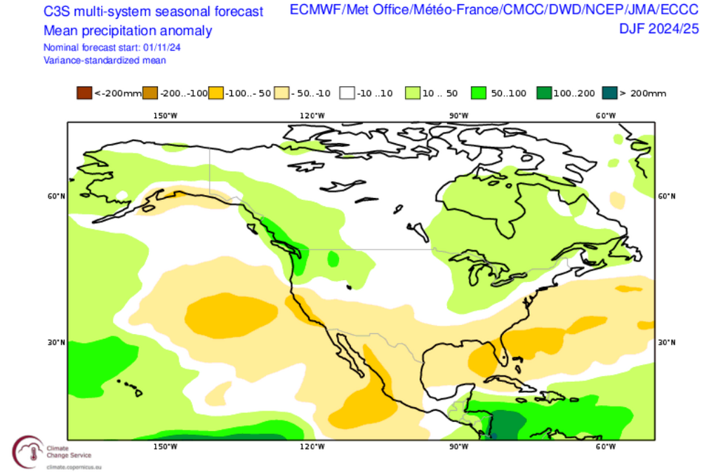
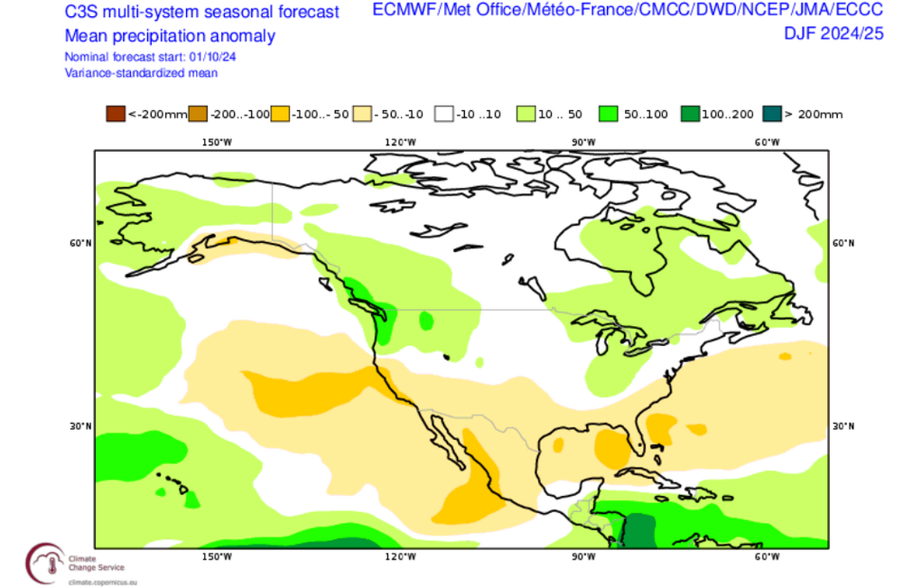
The final C3S winter 2024-2025 guidance is now in. Temperatures: Precipitation: October Comparisons: Temperatures: Precipitation: It should be noted that there is some variation on a month-to-month basis with December featuring the most widespread warmth (monthly average). There can still be shorter periods of cold that don't stand out on seasonal or monthly guidance. The upcoming cold shot for parts of the eastern half of the U.S. this week is one example.


-
Occasional Thoughts on Climate Change
donsutherland1 replied to donsutherland1's topic in Climate Change
A new paper, "Anthropogenic warming has ushered in an era of temperature-dominated droughts in the western United States", has revealed that the nature of droughts in the Western United States has changed due to climate change. Three key points: 1. The western United States has experienced a significant shift in the primary driver of drought, from precipitation deficits to high evaporative demand, primarily due to anthropogenic warming. This change occurred around the year 2000. Rising surface temperatures increase the atmosphere's capacity to hold water vapor, leading to higher evaporative demand and intensifying drought severity. 2. Historically, precipitation deficits were the main factor in WUS droughts, but since 2000, rising temperatures and resulting high evaporative demand have contributed more to drought severity (62%) and coverage (66%). 3. The paper revealed that natural climate variability is the dominant factor influencing precipitation, while anthropogenic warming is mainly responsible for the observed changes in evaporative demand. -
Clouds will increase on tomorrow with periods of rain developing during the evening and continuing into Monday. A general 0.25"-0.50" rainfall is likely. An additional round of rain is possible late next week. Aside from unseasonable warmth, next week will generally see near normal to occasionally somewhat below normal readings. Today is Philadelphia's 42nd consecutive day with no measurable precipitation. The old record of 29 days was set during October 11 through November 8, 1874. Wilmington, DE has also gone 42 consecutive days without measurable precipitation. The old record of 34 days was set during January 7 through February 9, 1909. Those record streaks will end tomorrow. The NAO fell to a preliminary -2.751 on September 24th (all-time September record: -2.371, September 12, 1971). That was the 9th lowest value on record. La Niña winters following September cases where the NAO fell to -1.900 or below featured a predominantly positive NAO. The most recent such winters were 2016-2017 and 2022-2023. The mean temperatures for those winters in New York City were 39.3° and 41.0° respectively. The 1991-2020 normal value is 36.2°. A warmer to much warmer than normal outcome is favored by the November run of the ECMWF for Winter 2024-2025. The ENSO Region 1+2 anomaly was -0.5°C and the Region 3.4 anomaly was -0.2°C for the week centered around October 30. For the past six weeks, the ENSO Region 1+2 anomaly has averaged -0.42°C and the ENSO Region 3.4 anomaly has averaged -0.33°C. Neutral ENSO conditions will likely evolve into a La Niña event during the late fall. The SOI was -2.29 today. The preliminary Arctic Oscillation (AO) was +0.691 today. Based on sensitivity analysis applied to the latest guidance, there is an implied 83% probability that New York City will have a warmer than normal November (1991-2020 normal). November will likely finish with a mean temperature near 51.5° (3.5° above normal).
-
I smelled the smoke yesterday.
-
It’s also the second warmest January-October period on record.
-
Tomorrow will be a noticeably cooler day. Temperatures will climb into only the lower 50s after starting out in the lower 40s in New York City and 30s outside the City. Clouds will increase on Sunday with periods of rain developing during the night and continuing into Monday. A general 0.25"-0.50" rainfall is likely. An additional round of rain is possible late next week. Today is Philadelphia's 41st consecutive day with no measurable precipitation. The old record of 29 days was set during October 11 through November 8, 1874. Wilmington, DE has also gone 41 consecutive days without measurable precipitation. The old record of 34 days was set during January 7 through February 9, 1909. The NAO fell to a preliminary -2.751 on September 24th (all-time September record: -2.371, September 12, 1971). That was the 9th lowest value on record. La Niña winters following September cases where the NAO fell to -1.900 or below featured a predominantly positive NAO. The most recent such winters were 2016-2017 and 2022-2023. The mean temperatures for those winters in New York City were 39.3° and 41.0° respectively. The 1991-2020 normal value is 36.2°. A warmer to much warmer than normal outcome is favored by the November run of the ECMWF for Winter 2024-2025. The ENSO Region 1+2 anomaly was -0.5°C and the Region 3.4 anomaly was -0.2°C for the week centered around October 30. For the past six weeks, the ENSO Region 1+2 anomaly has averaged -0.42°C and the ENSO Region 3.4 anomaly has averaged -0.33°C. Neutral ENSO conditions will likely evolve into a La Niña event during the late fall. The SOI was -14.64 today. The preliminary Arctic Oscillation (AO) was +0.986 today. Based on sensitivity analysis applied to the latest guidance, there is an implied 84% probability that New York City will have a warmer than normal November (1991-2020 normal). November will likely finish with a mean temperature near 51.7° (3.7° above normal).
-
I suspect that the 1950 record at Ann Arbor will stand for quite some time to come. It's just so far beyond anything that has occurred in January that it's difficult to see its being matched or broken anytime soon. The Detroit record might be something that could be challenged over the next decade or so.
-
Today was another warm day, though quite a bit cooler than yesterday's record warmth. However, parts of the Mid-Atlantic region experienced additional near record and record heat. Daily records included: Atlantic City: 81° (old record: 81°, 2022) Norfolk: 80° (old record: 79°, 2022) Richmond: 85° (old record: 84°, 2022) Salisbury: 82° (tied record set in 2022) Sterling: 80° (old record: 79°, 2022 and 2023) Washington, DC: 84° (old record: 81°, 2022) In addition, Norfolk's 80° day was its fourth this month. That tied the November record set in 1950 and tied in 1974. It will turn somewhat cooler for tomorrow, but temperatures will remain well above seasonal norms. The gradual cooldown will continue into the weekend. Some rain to affect the region Sunday night into Monday. Parts of the region could be in line for 0.25"-0.50" of rain. An additional round of rain is possible late next week. Today is Philadelphia's 40th consecutive day with no measurable precipitation. The old record of 29 days was set during October 11 through November 8, 1874. Wilmington, DE has also gone 40 consecutive days without measurable precipitation. The old record of 34 days was set during January 7 through February 9, 1909. The NAO fell to a preliminary -2.751 on September 24th (all-time September record: -2.371, September 12, 1971). That was the 9th lowest value on record. La Niña winters following September cases where the NAO fell to -1.900 or below featured a predominantly positive NAO. The most recent such winters were 2016-2017 and 2022-2023. The mean temperatures for those winters in New York City were 39.3° and 41.0° respectively. The 1991-2020 normal value is 36.2°. A warmer to much warmer than normal outcome is favored by the November run of the ECMWF for Winter 2024-2025. The ENSO Region 1+2 anomaly was -0.5°C and the Region 3.4 anomaly was -0.2°C for the week centered around October 30. For the past six weeks, the ENSO Region 1+2 anomaly has averaged -0.42°C and the ENSO Region 3.4 anomaly has averaged -0.33°C. Neutral ENSO conditions will likely evolve into a La Niña event during the late fall. The SOI was -11.46 today. The preliminary Arctic Oscillation (AO) was +1.443 today. Based on sensitivity analysis applied to the latest guidance, there is an implied 82% probability that New York City will have a warmer than normal November (1991-2020 normal). November will likely finish with a mean temperature near 51.7° (3.7° above normal).
-
March, for sure. I used February, because March had already seen 90° heat in parts of the Mid-Atlantic region previously and February has seen the highest temperature for any winter month.
-
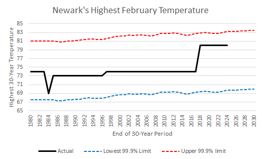
For February? Very unlikely anytime soon in the northern Middle Atlantic, much less New England regions. Based on average maximum temperature data and data for warming (at the 1980-2024 rate), such an outcome would be extremely unlikely for Newark, which recorded an 80° temperature in February 2018. Below is a chart showing the lower and upper 99.9% limits. By 2030, the upper-bound is likely to be 84°. Occasionally, the extremes break through such limits, as occurred in Phoenix in early October. However, the 6° difference between 90° and the upper bound by 2030 is so large, that it would be all but impossible to see a 90° February temperature in Newark or elsewhere in the northern Mid-Atlantic region through at least 2030.
-
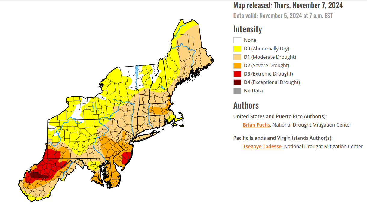
Latest drought outlook:

-
Under bright sunshine, temperatures rose to near record and record highs across much of the region. Some locations tied or set November monthly records. High temperatures included: Albany: 77° (old record: 73°, 2015) Allentown: 79° (old record: 78°, 1948) Atlantic City: 81° (old record: 77°, 1961) Baltimore: 81° (tied record set in 2015) Bangor: 75°(tied record set in 1938) ***Tied November monthly record*** Boston: 82° (old record: 76°, 2022) ***Latest 80° temperature*** Bridgeport: 73° (old record: 72°, 2022) Caribou: 72° (old record: 71°, 2022) Concord: 80° (old record: 75°, 1948 and 2022) ***Tied November monthly record*** Harrisburg: 80° (old record: 77°, 1948) Hartford: 84° (old record: 76°, 2015 and 2022) ***Tied November monthly record*** Manchester: 80° (old record: 77°, 2022) ***New November monthly record*** New York City-Central Park: 80° (old record: 75°, 2022) New York City-JFK Airport: 75° (tied record set in 2015) New York City-LaGuardia Airport: 80° (old record: 75°, 2015 and 2022) Newark: 83° (old record: 80°, 1948) Philadelphia: 80° (old record: 79°, 1948) Portland: 79° (old record: 71°, 2020) ***New November monthly record*** Poughkeepsie: 81° (old record: 77°, 2015) ***Latest 80° temperature*** Providence: 77° (old record: 75°, 2015) Reading: 83° (old record: 79°, 1975) Sterling: 83° (old record: 80°, 2015) Trenton: 80° (old record: 77°, 1948) Washington, DC: 83° (old record: 80°, 2015) Wilmington, DE: 81° (old record: 79°, 1948) Worcester: 78° (old record: 72°, 2022) It will turn somewhat cooler for tomorrow and Friday, but both days will still be unseasonably warm. There is growing model support for at least some rain to affect the region late in the weekend. Parts of the region could be in line for 0.25"-0.50" of rain. Today is Philadelphia's 39th consecutive day with no measurable precipitation. The old record of 29 days was set during October 11 through November 8, 1874. Wilmington, DE has also gone 39 consecutive days without measurable precipitation. The old record of 34 days was set during January 7 through February 9, 1909. The NAO fell to a preliminary -2.751 on September 24th (all-time September record: -2.371, September 12, 1971). That was the 9th lowest value on record. La Niña winters following September cases where the NAO fell to -1.900 or below featured a predominantly positive NAO. The most recent such winters were 2016-2017 and 2022-2023. The mean temperatures for those winters in New York City were 39.3° and 41.0° respectively. The 1991-2020 normal value is 36.2°. A warmer to much warmer than normal outcome is favored by the November run of the ECMWF for Winter 2024-2025. The ENSO Region 1+2 anomaly was -0.5°C and the Region 3.4 anomaly was -0.2°C for the week centered around October 30. For the past six weeks, the ENSO Region 1+2 anomaly has averaged -0.42°C and the ENSO Region 3.4 anomaly has averaged -0.33°C. Neutral ENSO conditions will likely evolve into a La Niña event during the late fall. The SOI was -6.30 today. The preliminary Arctic Oscillation (AO) was +0.806 today.
-
I hope so, too.
-
Records have already been tied or broken at New York City (Central Park), Newark, and White Plains. Bridgeport and Islip are 1° short of their daily records. Newark has reached 80° for the second time this month, which ties the November record from 1950.
-
Under bright sunshine, temperatures rose to well above seasonal norms. High temperatures included: Albany: 72° Bridgeport: 68° New York City: 73° Islip: 70° Newark: 76° Poughkeepsie: 76° Rochester reached 81°. That broke the daily record of 77° from 2022 and tied the all-time November record of 81° that was set on November 1, 1933. It is also the latest 80° or above temperature on record (old record last date: November 2, 1933) Tomorrow will see some locations challenge or break records. Highs will generally reach the middle and upper 70s. Warmer spots could reach 80°. It will turn somewhat cooler for Thursday and Friday, but both days will still be unseasonably warm. There is growing model support for at least some rain to affect the region late in the weekend. Parts of the region could be in line for 0.25"-0.50" of rain. Today is Philadelphia's 38th consecutive day with no measurable precipitation. The old record of 29 days was set during October 11 through November 8, 1874. Wilmington, DE has also gone 38 consecutive days without measurable precipitation. The old record of 34 days was set during January 7 through February 9, 1909. The NAO fell to a preliminary -2.751 on September 24th (all-time September record: -2.371, September 12, 1971). That was the 9th lowest value on record. La Niña winters following September cases where the NAO fell to -1.900 or below featured a predominantly positive NAO. The most recent such winters were 2016-2017 and 2022-2023. The mean temperatures for those winters in New York City were 39.3° and 41.0° respectively. The 1991-2020 normal value is 36.2°. A warmer to much warmer than normal outcome is favored by the November run of the ECMWF for Winter 2024-2025. The ENSO Region 1+2 anomaly was -0.5°C and the Region 3.4 anomaly was -0.2°C for the week centered around October 30. For the past six weeks, the ENSO Region 1+2 anomaly has averaged -0.42°C and the ENSO Region 3.4 anomaly has averaged -0.33°C. Neutral ENSO conditions will likely evolve into a La Niña event during the late fall. The SOI was -4.14 today. The preliminary Arctic Oscillation (AO) was +0.240 today.
-
There has been none warmer than the current outlook. But the archived data only goes back to November 2017.
-
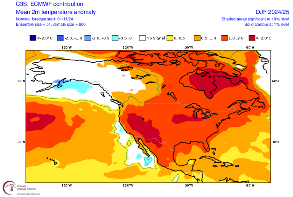
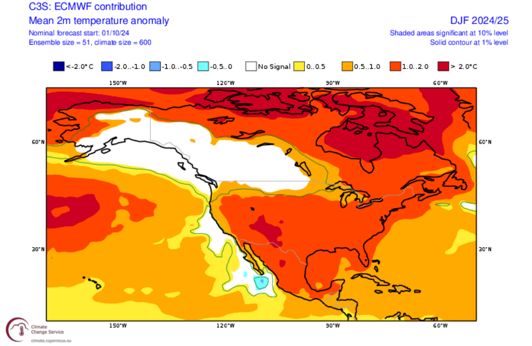
ECMWF Winter (December-February) Forecasts: From October: Latest:

-
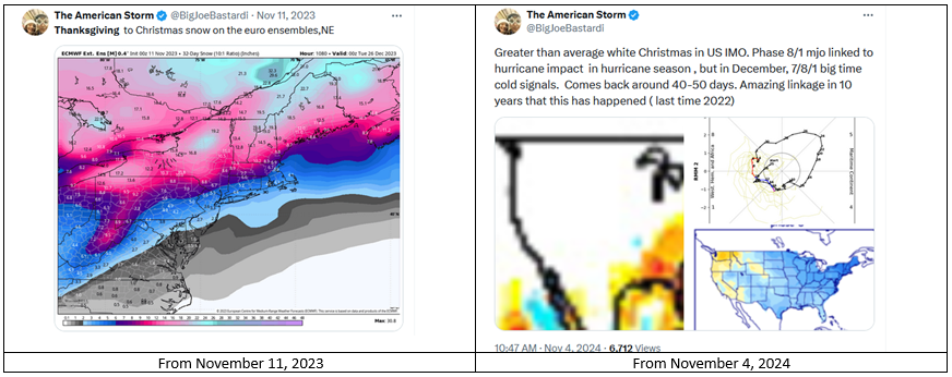
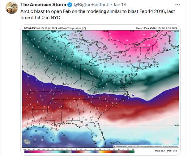
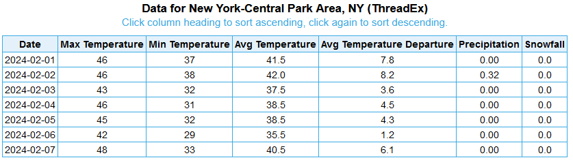
Dreaming of a White Christmas or "big time cold" in December? Joe Bastardi is suggesting above normal odds. The problem with that is that he makes similar calls on a regular basis during the first half of November. For example: There is no forecasting skill from this far out. Any successes are matters of random chance, not skill. Forecasting for specific dates in the distant future is more astrology than meteorology. The maps are intended to shock and draw attention. A similar posting pattern occurs throughout the winter where severe to extreme maps are posted on a regular basis. For example from last winter (January 18, 2024): The outcome for the first week of February 2024: And when the severe to extreme ideas don't verify, fresh calls for severe to extreme cold/snow are posted for future periods. Already, he's embracing December cold and snow after previously suggesting a cold second half of November with an above average idea of a white Thanksgiving (September 30th post). Most here are aware of his track record and forecasting tendencies. New members might not be aware. Thus, this post to alert them to be cautious about Social Media claims with wild maps.
-
Tomorrow and Wednesday will be very warm days. Some locations could challenge or break records on Wednesday. It will turn somewhat cooler for Thursday and Friday, but both days will still be unseasonably warm. There is growing model support for at least some rain to affect the region late in the weekend. Today is Philadelphia's 37th consecutive day with no measurable precipitation. The old record of 29 days was set during October 11 through November 8, 1874. Wilmington, DE has also gone 37 consecutive days without measurable precipitation. The old record of 34 days was set during January 7 through February 9, 1909. The NAO fell to a preliminary -2.751 on September 24th (all-time September record: -2.371, September 12, 1971). That was the 9th lowest value on record. La Niña winters following September cases where the NAO fell to -1.900 or below featured a predominantly positive NAO. The most recent such winters were 2016-2017 and 2022-2023. The mean temperatures for those winters in New York City were 39.3° and 41.0° respectively. The 1991-2020 normal value is 36.2°. A warmer outcome is favored by the October run of the C3S multi-model forecast for Winter 2024-2025. The ENSO Region 1+2 anomaly was -0.5°C and the Region 3.4 anomaly was -0.2°C for the week centered around October 30. For the past six weeks, the ENSO Region 1+2 anomaly has averaged -0.42°C and the ENSO Region 3.4 anomaly has averaged -0.33°C. Neutral ENSO conditions will likely evolve into a La Niña event during the late fall. The SOI was -11.01 today. The preliminary Arctic Oscillation (AO) was +0.154 today.
-
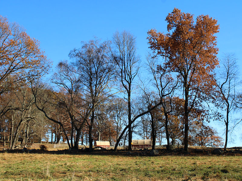
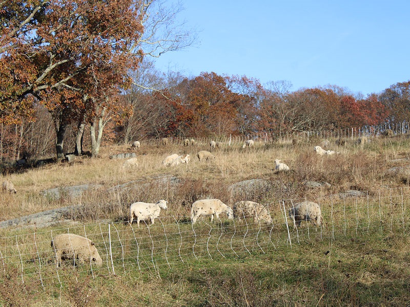
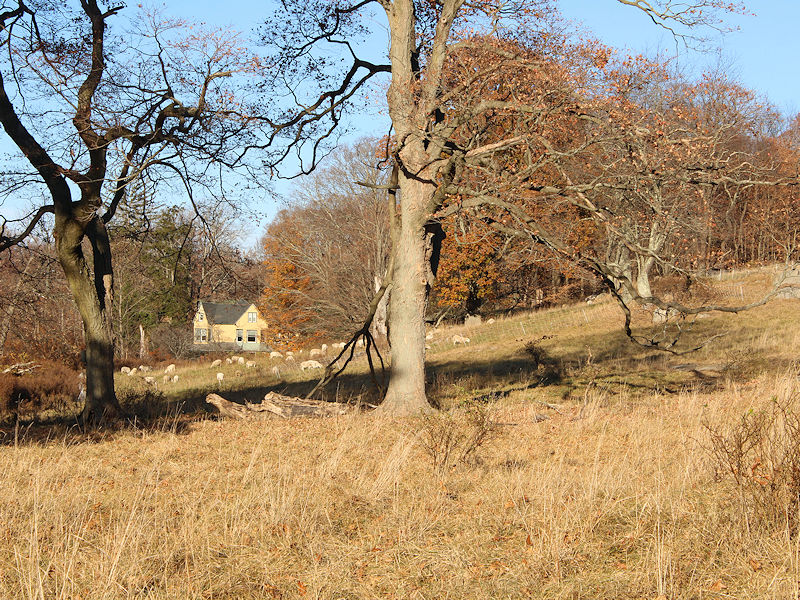
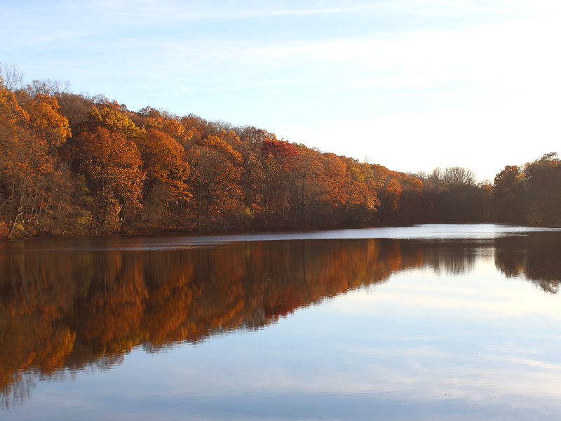
Some fall photos from this afternoon. Many of the leaves have now fallen.
-
A warming trend will commence tomorrow. Tuesday and Wednesday could be very warm days with some locations challenging or breaking records on Wednesday. Today is Philadelphia's 36th consecutive day with no measurable precipitation. The old record of 29 days was set during October 11 through November 8, 1874. Wilmington, DE has also gone 36 consecutive days without measurable precipitation. The old record of 34 days was set during January 7 through February 9, 1909. The NAO fell to a preliminary -2.751 on September 24th (all-time September record: -2.371, September 12, 1971). That was the 9th lowest value on record. La Niña winters following September cases where the NAO fell to -1.900 or below featured a predominantly positive NAO. The most recent such winters were 2016-2017 and 2022-2023. The mean temperatures for those winters in New York City were 39.3° and 41.0° respectively. The 1991-2020 normal value is 36.2°. A warmer outcome is favored by the October run of the C3S multi-model forecast for Winter 2024-2025. The ENSO Region 1+2 anomaly was -0.2°C and the Region 3.4 anomaly was -0.5°C for the week centered around October 23. For the past six weeks, the ENSO Region 1+2 anomaly has averaged -0.30°C and the ENSO Region 3.4 anomaly has averaged -0.38°C. Neutral ENSO conditions will likely evolve into a La Niña event during the late fall. The SOI was -9.67 today. The preliminary Arctic Oscillation (AO) was +0.257 today.
-
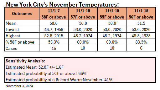
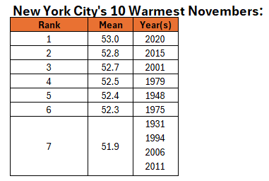
Both the ECMWF weekly and CFSv2 weekly forecasts show warmer than normal to much warmer than normal temperatures throughout November for the New York City area. That raises the question as to whether November 2024 will go on to become the warmest November on record. Historic data and sensitivity analysis suggest that a new record is plausible, even from this early in the month, considering the latest guidance through mid-month. 50% of New York City's warmest Novembers have occurred since 2000. Records go back to 1869. The 10 warmest Novembers have typically been followed by a warmer than normal winter (80% of cases) with 40% of cases seeing exceptionally warm winters (seasonal mean temperature of 40° or above). The mean winter temperature was 38.2° and the median winter temperature was 37.9°. Warmest: 41.6°, 2001-02; Coldest: 34.2°, 1975-76. In terms of snowfall, 70% of cases saw less than 20" of snowfall, including 30% with less than 10" seasonal snowfall. However, 30% of cases saw 30" or more seasonal snowfall. The mean seasonal snowfall was 18.4" and the median was 12.6". Highest seasonal snowfall: 42.0", 1948-49; Lowest seasonal snowfall: 3.5", 2001-02.