frd
-
Posts
6,934 -
Joined
-
Last visited
Content Type
Profiles
Blogs
Forums
American Weather
Media Demo
Store
Gallery
Everything posted by frd
-
I don't give a crap about the Canadian warming later in the month, say what you want, I just like the pretty colors.

-
There was also this Rehoboth Beach experienced a significant blizzard and "bomb cyclone" on January 4, 2018, which brought heavy snow, strong winds, and whiteout conditions. The storm resulted in a blizzard warning for Sussex County, an estimated 8 to 12 inches of snow, and a Level 1 driving warning issued by the Governor.
-
Certainly seems that way. Little skill outlook, more so just climo, Nina and warming.
-
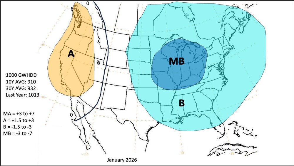
Focus on Jan 2026 from Allan Huffman @RaleighWx I posted my winter forecast on my patreon page with reasoning last week. But I will post my maps here just for reference/accountability. Last year my winter forecast stunk so take it for what it is worth.
-
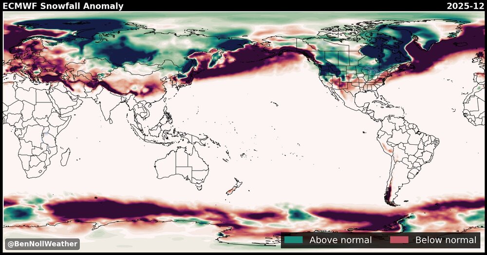
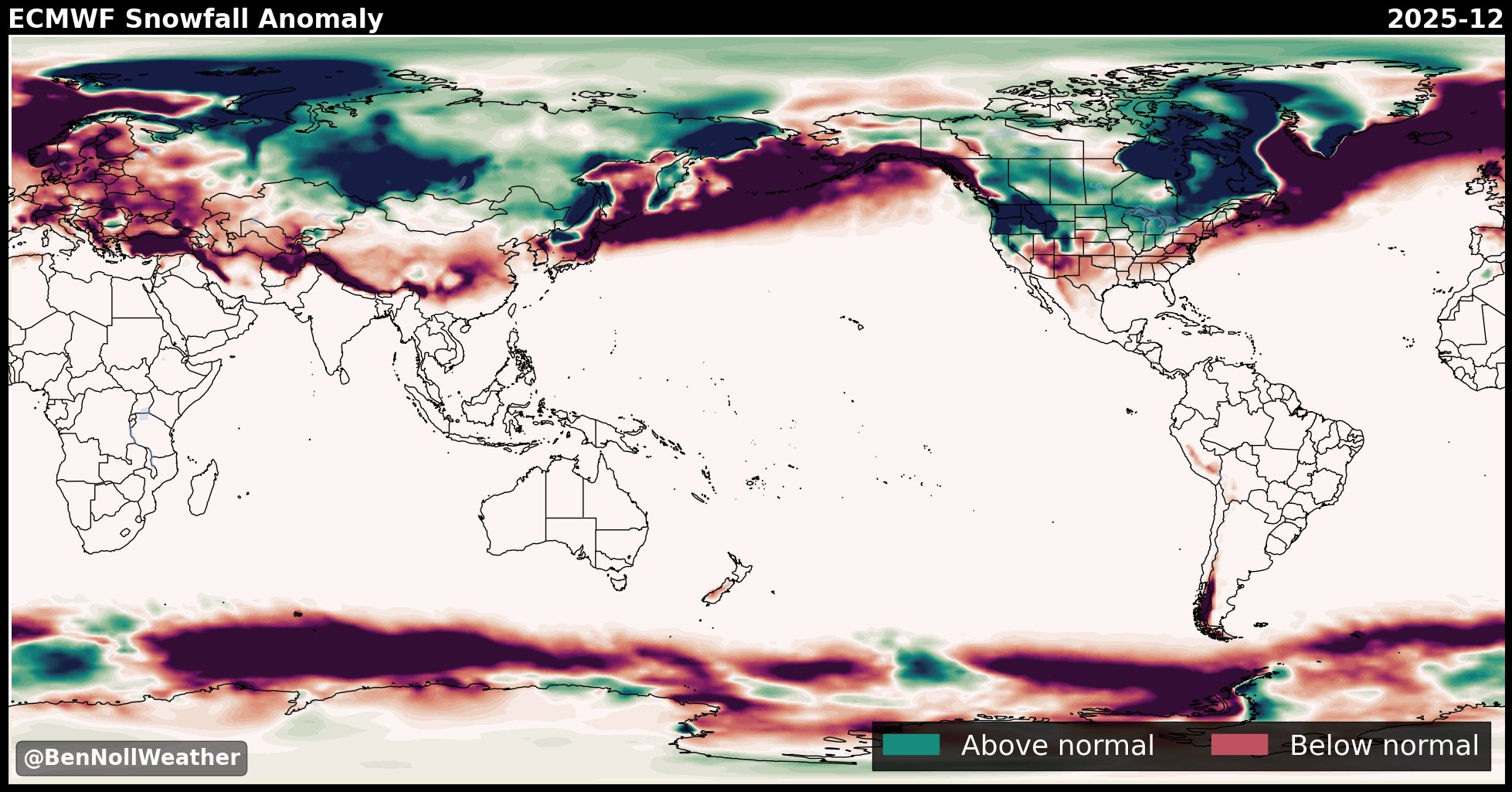
Lastest updated snowfall probs for December from the ECMWF. This is the fourth month in a row with sub normal December snowfall. I would think with all the changes taking place over the HL during the next weeks a lot can change in regards to December snowfall in the East. .
-
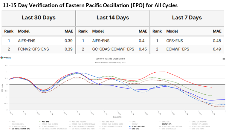
Commodity Wx Group @commoditywx Models debating speed of -EPO arrival with American fastest and European slowest; both have exhibited competitive skill in past 30 days, but AIFS ensemble middle ground may be best answer.
-
Impressive, but next week we warm up.
.thumb.jpeg.b0ec21daf2aea4dda1d881d1acfc8b6d.jpeg)
-
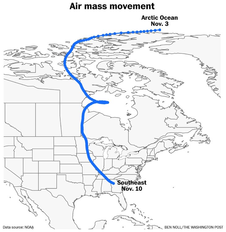
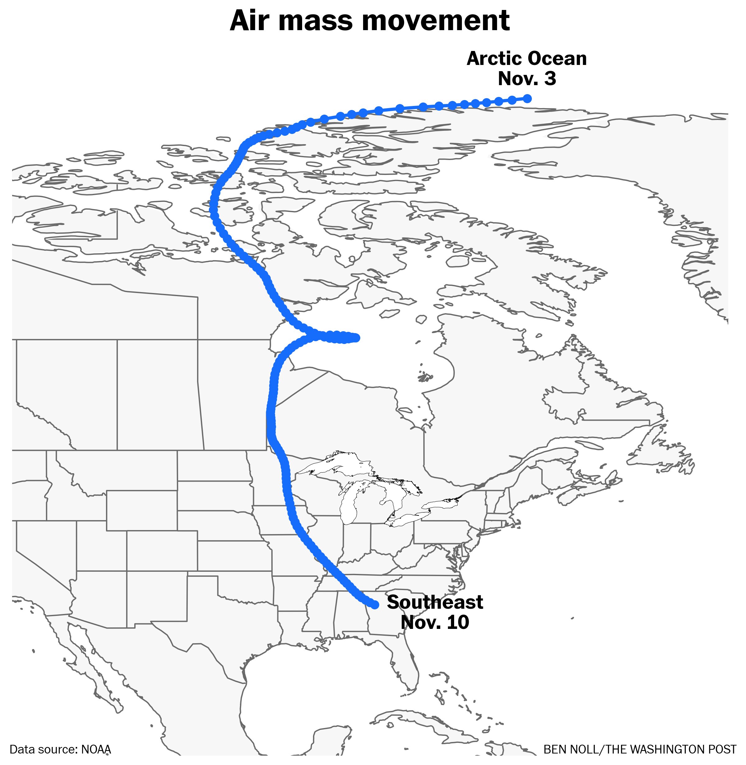
The delivery of the coldest air missed us to the SW and West. The SE and other locations had the largest negative departures plus snow showers. You can see below
-
AO forecasts continue more negative, now at - 3 SD
.thumb.png.c8d18674639c515ce0147aa8b25de539.png)
-
Thunder and lightning here. Not as crazy as where @CAPE is located, but much more rain than forecasted. Still more to arrive from my SW shortly.
-
Paul Roundy @PaulRoundy1 · 13h The algorithm is based entirely on outgoing longwave radiation data in the tropics. The OLR diagnostic algorithm is explained and assessed here: https://rmets.onlinelibrary.wiley.com/doi/abs/10.1002/qj.962 And the association with the extratropical circulation is diagnosed through the method of constructed analogs: https://journals.ametsoc.org/view/journals/mwre/141/7/mwr-d-12-00223.1.xml Since the algorithm does not include any explicit information about the ocean (it includes what is implicit in OLR anomalies), and since the OLR signal is projected forward based on how similar OLR signals moved in the past, it will do poorly when the ocean subsurface is undergoing strong changes. In the short term (e.g., next 2 months), the results are reasonable, but in this particular event, there is risk of El Niño being forced by strong subseasonal variability (February through May). Should that occur, the verification data would diverge from the forecast.
-
Lastest AO update 11/09/25 - an increased negative forecast without a return to going positive. Looking good !
.thumb.png.0c777d06591b056055b5e4df557366c1.png)
-
From Paul Roundy, this shows - NAO and Greenland blocking might be a frequent player during the upcoming winter.
.png.cfe1120bace46aad74c150b5c4069728.png)
-
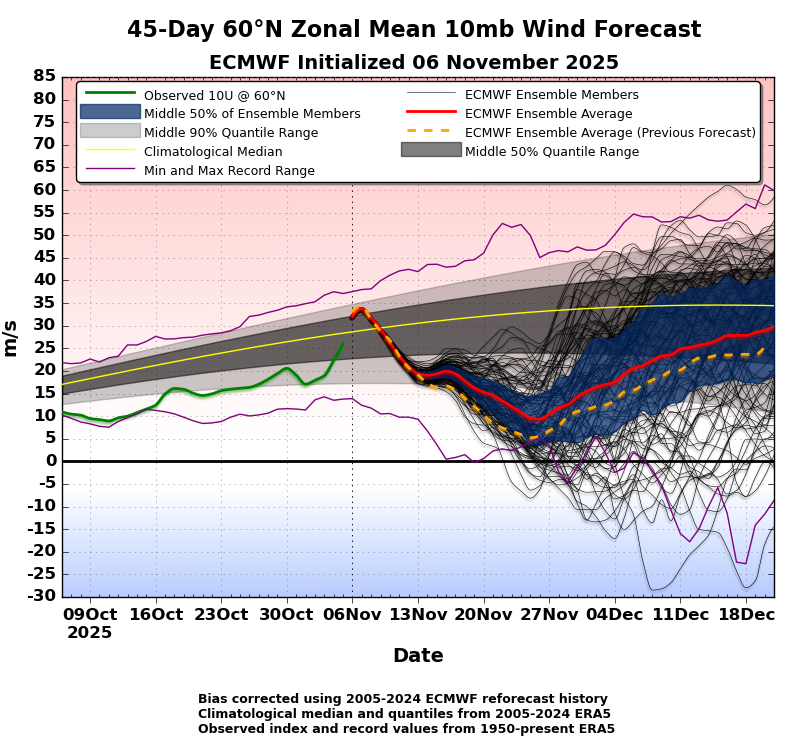
Latest ECMWF update regarding the 45 day 60 degree N Zonal Mean 10mb Wind Forecast. Of note, the ensemble average in this update is slighter higher than the previous ensemble forecast, however, still bullish for a weak PV.
-
Without help from the Pac you can have weeks and weeks of a - NAO and nothing will come from it in terms of snowfall for our area. As we know, depending on the pattern out West and in Canada some -NAO blocks don't work out for us, and some do not even produce a pattern that leads to a cold enough airmass for snow, it is all dependent on the pattern upstream. I do believe the MJO slows, evens stalls for a bit, but we will get to the favorable phases in December and January.
-
On Tuesday the most extreme negative temp anomaly will be in SE part of the country.
.thumb.jpeg.2d20af29291937c0ce664434ef61780b.jpeg)
-
Ladybug invasion here ! Hundreds of them everywhere. Its like a Ladybug Woodstock Festival !!!!

-
This would not at all surprise me that December is cold but with below normal snowfall. Ben Noll @BenNollWeather 1h There are signs that December is going to be particularly chilly this year, but does that mean it's also going to be snowy? It depends where you live. In past years with similar climate characteristics to this year, northern states had the highest odds for above-average snowfall during December. Using history as a guide, regions such as New England, the Great Lakes, Midwest, northern Plains and Intermountain West are favored to be snowier-than-average next month. The Northeast, including the big cities, is more of a question mark and could go either way. The Southeast and Mid-Atlantic might lack moisture, reducing the odds for snow storms.

-
Of course there is very little fundamental accuracy this far out however it would be nice to see a more robust signal for precipitation in our area. A lot will depend on the configuration and presence of blocking if we are to get any snowfall prior to the holidays. And years past going far back with a Nina when it has been cold in December which has happened on quite a few occasions it has normally been dry right when the cold snap ends was when the precipitation set in as you can imagine a typical occurrence cold dry warmer wetter.
-
Encouraging signal with the AO.
.thumb.png.35c14051494613a2d4f12cd5030dbb78.png)
-
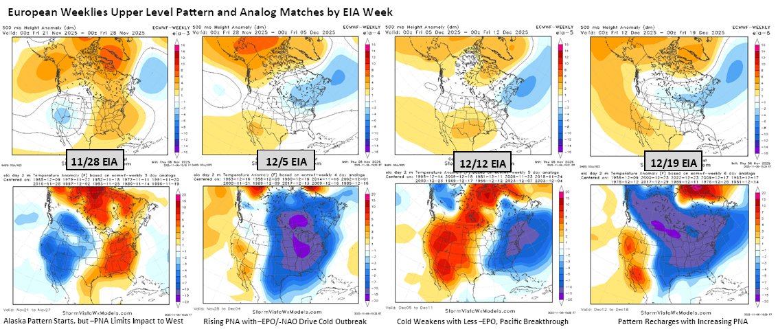
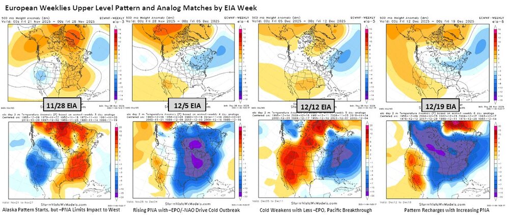
This December seems to have decent below normal temp departures in our area, and in the East overall. Snow chances would be elevated. Commodity Wx Group @commoditywx European weekly upper level patterns favor colder than normal 12/5, 12/12, and 12/19 EIA weeks for U.S.
-
Might be related to ideas about favorable and longer lasting MJO effects in winter, and the possibly strat evolution later in December. Just a guess. Webb posted this as a link. https://agupubs.onlinelibrary.wiley.com/doi/full/10.1029/2023GL104826
-
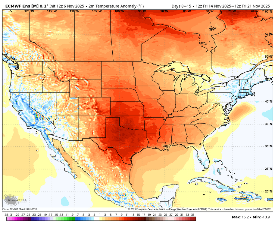
GFS Ens and ECMWF Ens both agree with a rather warm look across the conus, with the exception of our region and the NE part of the country, during days 8 to 16. The warm up is most pronouced in the center of the country. Canada also warms a bit.
-
We know there have been some memorable snow chases at the beach, specifically Bethany and Rehoboth during previous winters such as this one coming up featuring Nina background state. This forecast has that area in 0 to 6 in. Will be interesting to reflect back on this forecast once we get to early March.


.jpeg.8a7c29139f54f137cbad696fcbd5801a.jpeg)
.png.df75c1f783011f09f1323c0c794e869f.png)
.png.e34b56b85f6da1a4cc877150ecd8285d.png)

.jpeg.1bd3e6ccdfc23a4e13d428375aee3402.jpeg)


.png.97203a0cbe4c471514a547d2711ce0e2.png)