frd
-
Posts
7,129 -
Joined
-
Last visited
Content Type
Profiles
Blogs
Forums
American Weather
Media Demo
Store
Gallery
Everything posted by frd
-
Cell developed rapidly NE of Wilmington, DE. and is moving right up I-95 towards Philly.
-
More of a heavy rain threat. Skies have cleared here for the most part.
-
Up and down pattern continues
-
-
WPC increased overall precip 7 day totals ( most of that is early week )
-
Mount Holly more bullish with the heavy rain wording, we shall see. Good luck !
-
There were times in the past that had major PV disruptions during a El Niño / +QBO combinations. They tended to ocur in later winter versus early in December to Jan.
-
Winter 26-27 with averaged - NAO . Also. Appears a weakened or displaced PV
-
-
- 1,007 replies
-
- 1
-

-
- severe
- thunderstorms
- (and 7 more)
-
- 259 replies
-
- 2
-
-
- we got burned
- rugpull central
- (and 1 more)
-
Seems that the Nino is already effecting the 500 look next week to late month.
-
Persistence
-
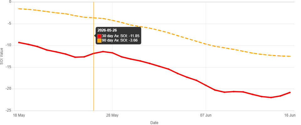
SOI Dashboard Latest Southern Oscillation Index values SOI values for 16 Jun, 2026 Average SOI for last 30 days -20.85 Average SOI for last 90 days -12.51 Daily contribution to SOI calculation -3.30 Monthly average SOI values Mar 7.59 Apr -9.88 May -13.22 30 day Av. SOI 90 day Av. SOI Daily contribution Date Tahiti (hPa) Darwin (hPa) Daily Contribution 30 day Av. SOI 90 day Av. SOI 16 Jun 2026 1015.72 1014.90 -3.30 -20.85 -12.51 15 Jun 2026 1014.15 1014.70 -12.93 -21.65 -12.43 14 Jun 2026 1012.95 1015.20 -24.88 -21.99 -12.27 13 Jun 2026 1013.31 1016.35 -30.44 -21.77 -12.05 12 Jun 2026 1013.95 1016.80 -29.10 -21.27 -11.81 11 Jun 2026 1015.79 1016.65 -15.11 -20.72 -11.37 10 Jun 2026 1015.93 1015.45 -5.69 -20.61 -10.91 9 Jun 2026 1014.09 1014.60 -12.65 -20.73 -10.58 8 Jun 2026 1014.36 1016.70 -25.52 -20.24 -10.22 7 Jun 2026 1014.05 1017.70 -34.73 -19.19 -9.71 6 Jun 2026 1013.94 1016.55 -27.42 -18.06 -9.05 5 Jun 2026 1012.20 1015.15 -29.81 -17.33 -8.44 4 Jun 2026 1010.52 1014.25 -35.29 -16.43 -7.77 3 Jun 2026 1010.14 1013.80 -34.80 -15.47 -7.10 2 Jun 2026 1012.48 1015.05 -27.13 -14.79 -6.56 1 Jun 2026 1013.74 1014.85 -16.87 -
-
Some changes as we move towards the third week of June.
-
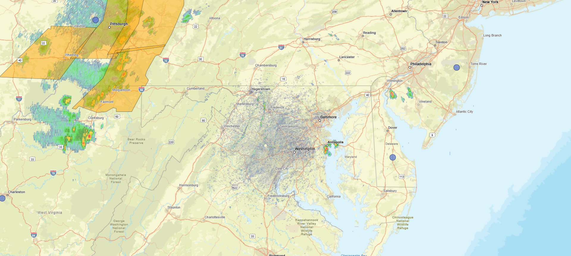
A few tiny cells popping up in extreme northeast Maryland
-
Larger view on the Days 0 to 46
-
Yes, in my mind I know summer here can go to October, but there is always a chance .005% At least soon we will pass the peak sun angle.
-
Could use more rain, but temps not bad. Worse of the heat behind us?
- 259 replies
-
- 1
-

-
- we got burned
- rugpull central
- (and 1 more)
-
Several cells pivoting East of DC moving NE.
-
Quick moving small storm hit here .14 At least it cooled off the garden.
-
Several cells popping up already.

-
https://x.com/RyanWeather/status/2064837035706163334
-
Middle of next week has potential.
- 259 replies
-
- 2
-
-

-
- we got burned
- rugpull central
- (and 1 more)