frd
-
Posts
6,931 -
Joined
-
Last visited
Content Type
Profiles
Blogs
Forums
American Weather
Media Demo
Store
Gallery
Everything posted by frd
-
December 2021 Medium/Long Range Discussion Thread
frd replied to North Balti Zen's topic in Mid Atlantic
We all laugh at Dr Cohen @CAPE , but I will say this, last year looked better at this point. We had record NA snow cover and a cold period in December. ( even though we experienced the same typical warmth period after Dec. 15 ) I think there is something to be made of a healthy cryosphere and extensive snow cover. So far the AO forecast have been getting uglier and uglier. -
December 2021 Medium/Long Range Discussion Thread
frd replied to North Balti Zen's topic in Mid Atlantic
Take this with a grain of salt. But, in a Nina and with the base state we have I can see this happening. -
December 2021 Medium/Long Range Discussion Thread
frd replied to North Balti Zen's topic in Mid Atlantic
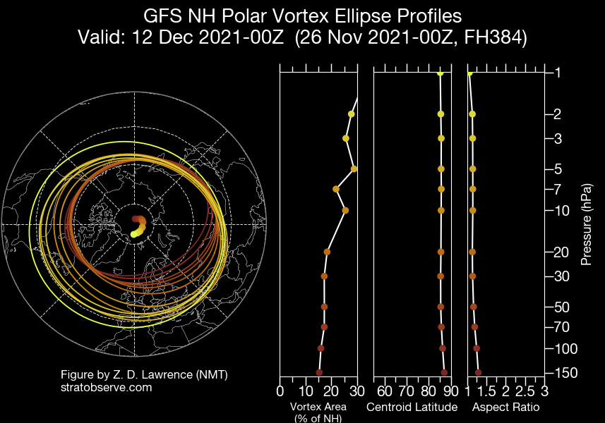
It appears that the early seasonal forecast from the euro and even the UK met portraying a weakening of the vortex at the end of November and in early December is not going to pan out. The vortex remains firmly planted over the North Pole and doesn't even offer any displacement towards North America. It would appear that those calling for a front loaded winter may not get it. It would be ironic if the heart of Winter produces which is not typical of a la Nina. -
December 2021 Medium/Long Range Discussion Thread
frd replied to North Balti Zen's topic in Mid Atlantic
I have not seen the Control for the GFS or the Euro score a win in many years during the late Fall or Winter when it comes to predicting potential snowfall. Meanwhile, I would be concerned regarding a poor NAM state, and the lack of any posts from HM about the upcoming winter..thumb.gif.6dcf297bf90bd7cc07555cf8c6a25285.gif)
-
December 2021 Medium/Long Range Discussion Thread
frd replied to North Balti Zen's topic in Mid Atlantic
Even later December not looking good for winter weather lovers. The PV is consolidated near the North Pole and there is no sign of a displaced or stretched out PV into North America. Meanwhile the AO looks to stay positive and there are no solid precurrsors to any significant strat warming. Things can change but at the moment very boring weather..thumb.gif.c77634ef70fa7c89839b98c5bf7353e3.gif)
.thumb.png.903d2829bdc4f1a9b2f630e62bf58a65.png)
-
December 2021 Medium/Long Range Discussion Thread
frd replied to North Balti Zen's topic in Mid Atlantic
Also of note, the potential of a favorable MJO passage later in December, however, the amplitude remains uncertain. Still, something to keep track of in the days ahead. -
December 2021 Medium/Long Range Discussion Thread
frd replied to North Balti Zen's topic in Mid Atlantic
Interesting despite the gloomy prospects of an early winter in the East. -
Pretty colors.
-
I wish I were in Canada.
-
AAM looks like it might fall off later in the month. However, the last image shows what a - GLAMM might look like with anomilies less than -0.5
-
Seems the last few years the best patterns for us never coincides with our best climo. Last year when we thought we were going to get nailed by extreme cold and snow ( during the strong blocking episode ) the entire threat area shifted way SW leading to the crippling Texas snow/ice and severe cold outbreak. I believe the block shifted West and we were left with scraps.
-
Low of 30 with frost.
-
Signal is there for a big storm. I am sure New England will cash in.
-
Significant changes in concensus moving forward with the AO. Most members take it negative. A great sign moving forward. Also, no sign at the moment that the SPV and the TPV are going to couple. Also of interest is the robust signal for a very negative NAO moving forward. Could be an active and cold weather period for the East later in the month and in early December.
.thumb.gif.c1b3155c33ce2e5fa2043fa6f200a428.gif)
-
More support growing for a - NAO later this month. Extensive Atlantic wave breaking is forecasted leading up to this.
-
This Friday night will be the coldest of the season so far. Snow showers for some before 8 or 9 AM. Friday morning.
-
This might help the back end of winter I believe since there is a delay from ocean to atmosphere. Do you know how long it actually takes to occur, if indeed it focuses more East by early to mid December?
-
Interesting potential on a - NAO signal out in time. If it happens then the question is, does it retrograde further WSW in a ideal Davis Straight block.
-
If your kitchen is hot on Thanksgiving Day you might get relief this year by opening the windows verus needing the AC on.
-
Snow showers in the forecast here for this coming Friday, I had to look twice, thought I was in the wrong zone. Friday A chance of snow showers. Sunny, with a high near 49. Chance of precipitation is 30%.
-
Pretty cool loop.
-
That event produced here and was actually under-forecasted. Given it was mid-November it made the event more remarkable. I still remember the long traffic delays.
-
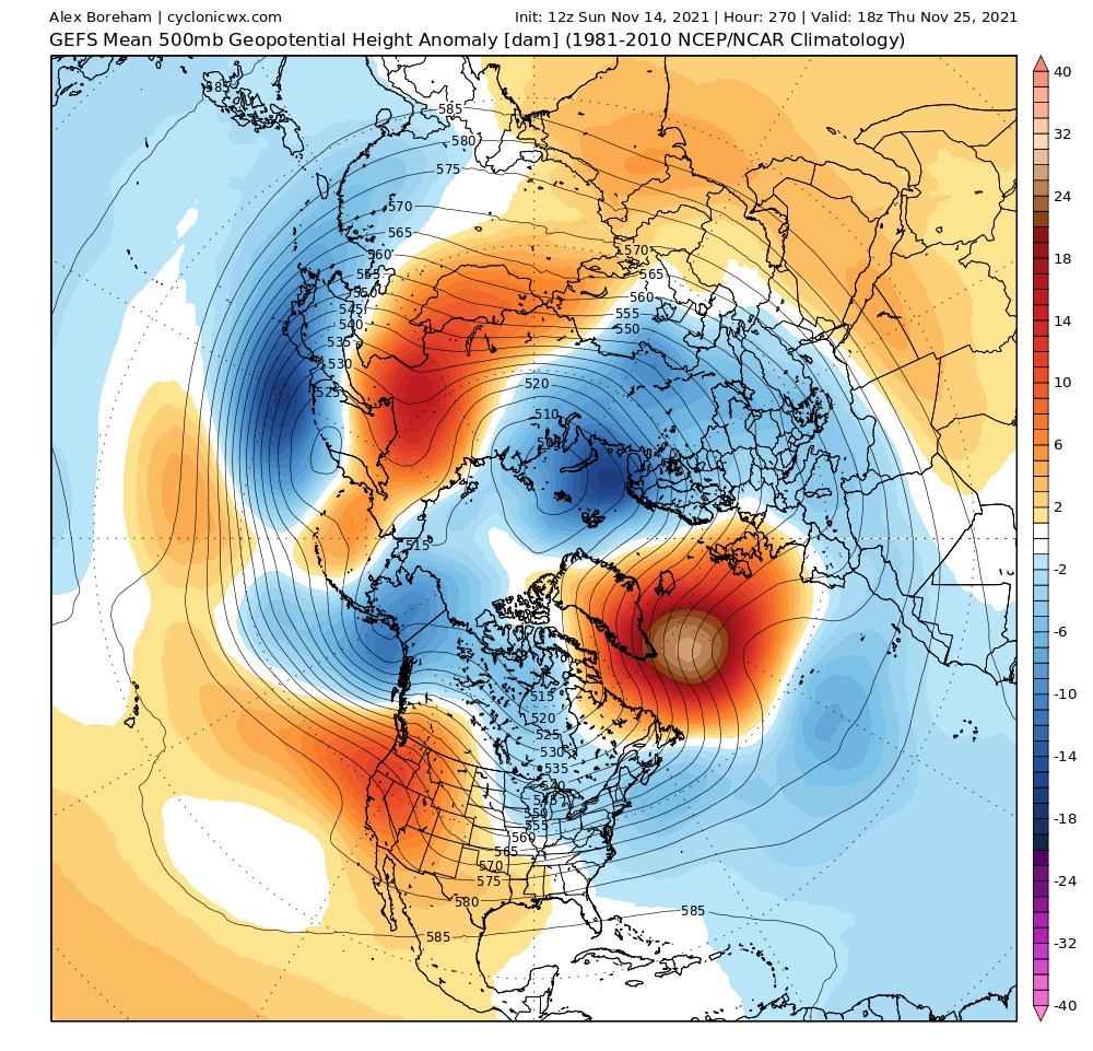
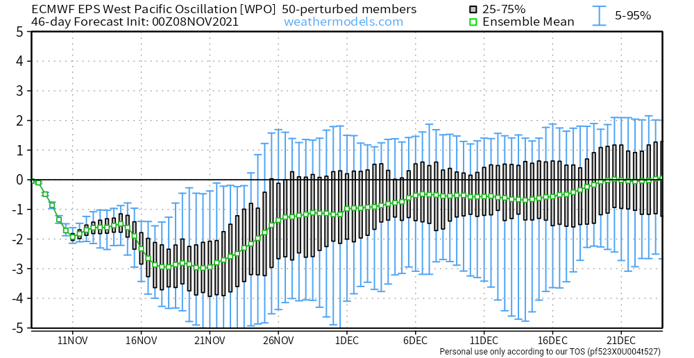
WPO is going to tank and hopefully stay that way into December.
.gif.7801d2737948c38b02668bb4a7ed4a63.gif)
.gif.72f6602a75bbccdfd989a13f3f1222e2.gif)
.png.e829b931f5edd0155f8b844b67b2f8af.png)


.gif.2b0cba157f030cc2eda11355e8aaf5f9.gif)