

rimetree
-
Posts
1,650 -
Joined
-
Last visited
Content Type
Profiles
Blogs
Forums
American Weather
Media Demo
Store
Gallery
Everything posted by rimetree
-
 54F and .71 of rain so far. Wind gusted to 32mph earlier in my somewhat sheltered back yard. Pretty noisy out there.
 -
Temps going the other way now. 44F. 0.42" Happy Thanksgiving all
-
Yeah, just when you need Tip's Hadley cell compressed, isohypnotic fast flow, etc. it's nowhere to be seen.
-
Would welcome a December '75 redux for this area. Almost 2F below normal and 27.5 inches of snow.
-
If you like "in the rough" lobster, Chauncey Creek over in Kittery does a nice job. Haven't been there in years so not sure if they've softened to appease the tourists but it was mostly bring your own everything except the lobster and maybe steamers.
-
1.92" in the tipper today with a nice thunderclap to boot. Almost 3.38 so far in November.
-
And reverse modelology, where everything that looked good last winter turned to crap, therefore, the inverse must be true this year. I admit to dabbling in this myself.
-
60F Nice out there
-
Outdoor lights went up yesterday. Tree goes up today way earlier than usual, but it will help brighten things up a bit.
-
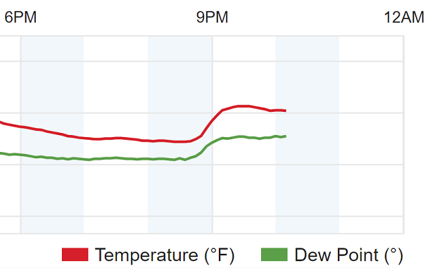
Hit 74.8 today. Interesting little bump in the temps around 9PM...went from 54 to 61 in about 20 minutes. Sea breeze flipped to land breeze I assume...
-
Let's re-introduce wolves...keep the coyote population in check.
-
Interesting, I just looked out at a big oak up the street and it's definitely picked up the pace with the leaf drop. It's like they're all going at the same time.
-
Damn...75F.
-
Hearing of a lot of strep going around too.
-
Up to 70F here now. What a beauty.
-
1989?
-
2.02 on the day. Good drink.
-
Looks like 1.11", which is pretty close to other stations nearby so the new Davis seems to be set up ok.
-
Selling my snowblower this afternoon...epic season incoming.
-
I remember visiting the Admiral Peary Museum of arctic exploration at Bowdoin some time back in the early 90s. Just made me think of how crazy those people were trying to get to the North Pole, let alone the South Pole, with such low-tech equipment.
-
Mid-late October could be pretty wild given the right timing
-
If I recall correctly, Euro had Sandy in a similar position before moving gradually down the coast to NJ left hook
-
Nearby...Duck Lake
-
Might have to chase up at camp in Lakeville if that Euro solution actually materialized.
-
Saw this on the first episode of a Netflix show called Connected. The veery bird says the 2020 season may not be as bad as NOAA is predicting... https://www.audubon.org/news/are-these-birds-better-computers-predicting-hurricane-seasons “Whatever it is, they know by mid-May,” he says, explaining that the average date of all nesting attempts in years with low ACE was after May 23. Will be interesting to see how it plays out.

