

WxUSAF
-
Posts
28,578 -
Joined
-
Last visited
Content Type
Profiles
Blogs
Forums
American Weather
Media Demo
Store
Gallery
Everything posted by WxUSAF
-
Fantastic thread here on ensemble clusters for the upcoming pattern
-
It’s early, but I think they should have the expectation of at least quarterfinals if not semis in 2026.
-
Yes, yes it is
-
The -NAO starts building at D5. That’s not fantasy land.
-
Wooooo baby
-
LOWER abdomen
-
I hate having to follow this on bbc live blog instead of watching
-
12z euro similar but farther south than GGEM so no snow.
-
12z Op GFS was the toaster bath scenario but 12z GEFS looks solid. Very similar to 0z EPS.
-
12z GGEM shows this @CAPE scenario for Dec 9 with a modest VA hit.
-
The general way I see things is this, with the progression shown like the 0z eps and most recent ensemble forecasts. Pattern changing cold front: Dec 7 Clipper or southern slider pattern: Dec 8-12 EC storm pattern: after Dec 13
-
This was my thought when I responded to @brooklynwx99 yesterday when he was saying it looks like a big dog pattern. It does! But there are like zero big dog events in our area before mid-December (and few in December total) for a reason. So we need to scale our expectations accordingly and recognize that our path to victory is not the same as for our “friends” to the north.
-
Excess stratospheric water vapor warms the surface through the normal greenhouse effect, but it cools the stratosphere itself through that IR emission. You’re already seeing this in the southern hemisphere with a very cold stratosphere. That’s why, from a weather weenie POV it could be bad for snow chances as it would tend to reinforce a cold stable strat wintertime PV.
-
That sucks @mappy. Hope it clears quickly!
-
I had to google “phwoar”
-
I think so yes. Not sure how much the chemical composition of the magma may have also played a role.
-
Nature paper: https://www.nature.com/articles/s43247-022-00618-z
-
I’d like to see it be January during El Niño
-
Not unless it gets much bigger than it currently is. These aren’t explosive eruptions, so all the gas release is near the surface and not into the stratosphere.
-
Yes, very minimal SO2 release, but directly injected a massive amount of H2O to the strat and mesosphere. My colleagues have estimated a couple tenths of a degree warming over next couple years from this. Nature paper from Nov 19 finds a net climate warming signal already.
-
He’s referring to the MJO: https://www.cpc.ncep.noaa.gov/products/people/wd52qz/mjo/mjo_chi.shtml 200mb velocity potential is termed “chi” and “k=1” refers to wavenumber one.
-
Yes. Canonical volcanic climate response is summertime continental cooling and wintertime warming due to a strong +AO.
-
Pinatubo and HT are VERY different eruptions and Pinatubo was 4 years before 95-96 winter.
-
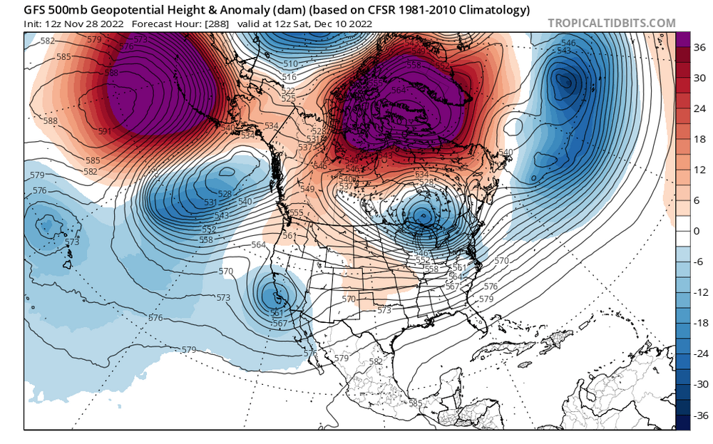
Crazy -NAOs can do amazing things. For instructional purposes and to show the type of opportunities we could see in December with this type of block: This is a complete big dog H5 pattern. Mega west-based -NAO, longitudinally extended trop PV underneath, and a strong shortwave entering in CA. But it’s mid-December and a Niña, both of which are factors working against big dogs. GFS squashes this shortwave, which is not a surprising outcome in a Niña. Still, we might get some enticing Op runs in the days ahead.
-
It was a thorough team loss. Except for Tucker.


