WxUSAF
-
Posts
28,684 -
Joined
-
Last visited
Content Type
Profiles
Blogs
Forums
American Weather
Media Demo
Store
Gallery
Everything posted by WxUSAF
-
Good win or great win? Lol
-
Great drive by him.
-
Fun play design although I bet it wasn’t supposed to be thrown into quintuple coverage.
-
I haven’t looked at any guidance this weekend besides charts that have been posted here, but I want to see the Pac pattern easing get to D8-9. Seems like based on what people have posted, we’re on the hairy edge of that? Hopefully it holds through Tuesday-Wednesday.
-
This game should end the charade that is the 2022 ravens
-
I’ve always mowed in early December to cut the grass short and chop leaves.
-
Eh…like are there stronger shortwaves now? Not sure. I don’t follow it closely but the link between climate and baroclinicity seems less certain.
-
Yes exactly. What is indisputable is that our winters are warmer by every metric. The shift to wetter conditions hasn’t been as dramatic in winter months, but it’s there too. So with more precipitation and less snow, it’s not hard to implicate the warmer temps. But that increased moisture gives us a better chance at the rare big dog.
-
I think it’s hard to put a date on it because snowfall has always been a highly variable number in our area. But since the 80s and 90s we’ve really gotten into a boom-bust cycle where before then, the bust years were far less frequent.
-
Yeah probably something like that. We need more anomalously cold air then we did 20-40 years ago. But we also have generally wetter conditions. Probably why a higher proportion of our snow now is in rarer larger events and we’re losing a lot of the lighter events with borderline temps.
-
The -PNA is part of the problem obviously but we could have probably dealt with this level of -PNA (weak to moderate) if we had trapped the PV underneath the -NAO. Without that, we’re just trapping in modified garbage air masses and then popping SE ridges.
-
How about some freaking Gio Reyna time? What could we possibly have to lose by it??
-
I think this experience will really set this group up well in 26. The talent pool has gotten deeper quickly and is continuing to deepen. Lots of quality US players playing in European leagues.
-
Only SiriusXM I think
-
The -PNA of goals
-
Seems like Berhalter goes to prevent defense every 2nd half so if we hold a draw at the half he’ll probably start playing to make it to PKs.
-
What does it it take for a damn Gio Reyna sighting!?!
-
Does that count in lieu of your 70F day?
-
Hovering on the MacBook just shows "Weenie" or "Thanks", etc.
-
I'm trying now with my MacBook and same thing. The board must hate me.
-
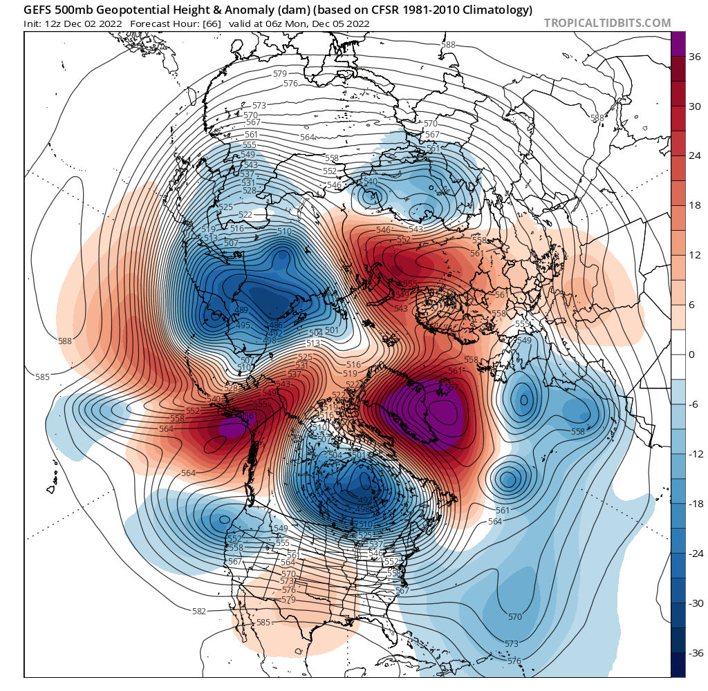
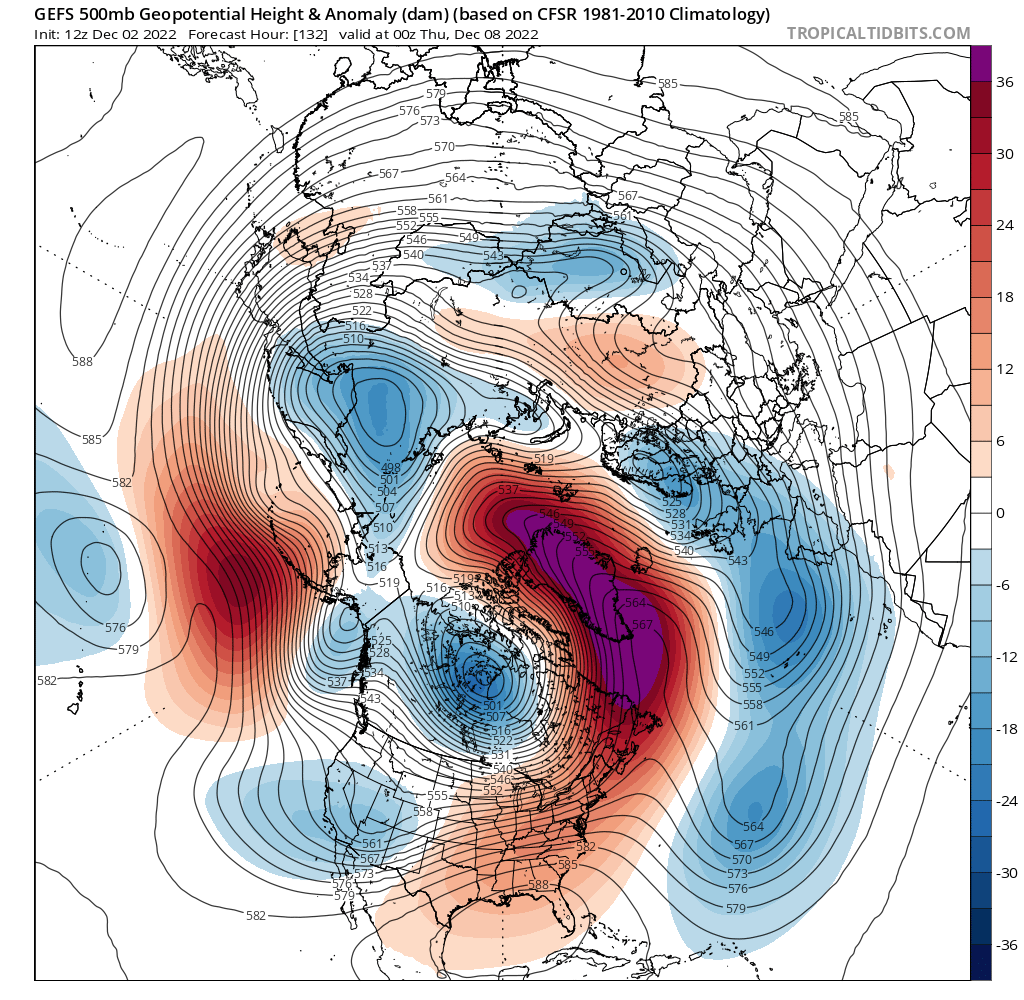
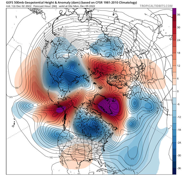
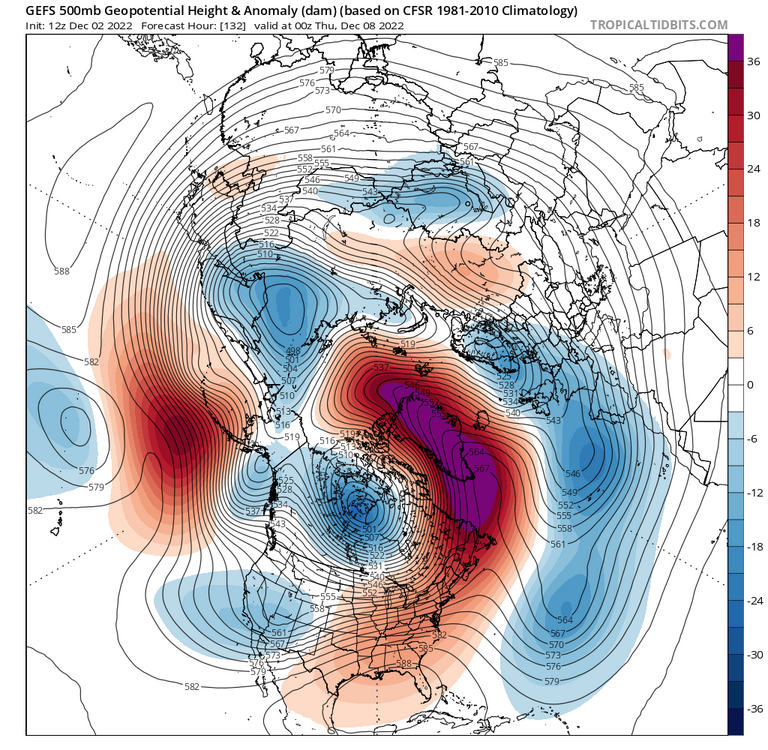
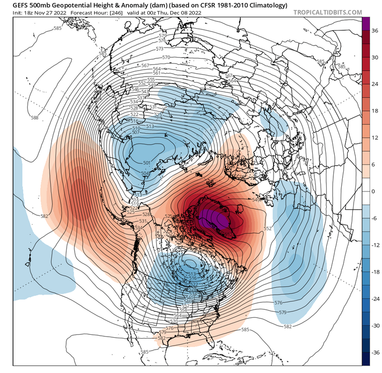
6z GFS and 12z Euro show that we still have a possible storm window in the Dec 9-10 window and probably more chances beyond that. But from a RELOAD/pattern point of view, it's become clear that things will take more time and/or be more variable. Two reasons for that that I see. Kudos to Prince GEFS here for sniffing this out sooner than King EPS. 1. Our ridge bridge is not going to capture a piece of the tropospheric PV underneath it like we thought it would. Look here, we're going to get our ridge bridge with the PV underneath! But, it doesn't last. The AK ridging wobbles back west, opening a big fat exit door and the PV escapes. This is what also helps let the SE ridge flex. No PV to squash it down. It also means we're stuck with somewhat mediocre air masses vs some good arctic air. Contrast that to what we thought we'd have as of last weekend. We thought/hoped the ridge bridge would persist, and keep the PV trapped. But it doesn't look like it. 2. The damn -PNA. It's a Nina, so can't be surprised, but it just doesn't want to quit. If we had that PV underneath our -NAO (which does seem wonderfully strong and persistent across all guidance), we could manage the fairly modest -PNA that seems to never want to quit. But without that cold air mass nearby helping to change the waveguide and force a trough over us, even the somewhat mediocre -PNA shown on today's 12z GEFS would give us fits. Not sure how this all plays out besides continuing to counsel patience. The very good news is that we seem to have a very durable -NAO/-AO combination building within the next 3-4 days. It's not fantasy land! The blocking is coming. Question is when we can take advantage. With that blocking around, Op guidance will produce weird solutions and combine that with the Nina and it's not a recipe for long-track storms regardless. With that blocking, if we can time up a shortwave with a fresh airmass, we can cash in quick.
-
Nope. Don’t get that. If I really tap and hold I get this iPhone function.

-
Great WPC met who is hopefully not a closet snow-hater.
-
Request submitted. Welcome @wxmvpete!
-
No Nope. I’m tapping away like an idiot and nothing happens