WxUSAF
-
Posts
28,773 -
Joined
-
Last visited
Content Type
Profiles
Blogs
Forums
American Weather
Media Demo
Store
Gallery
Everything posted by WxUSAF
-
Kinda crazy to think, but by next Thursday the 15th, it’s quite plausible that we will only have had 3 AN in the month! The 3rd, 7th, and today. But because all 3 of those days are double-digit warm departures, the total monthly departure by next week could be pretty modest. Poor @leesburg 04. No 70F before the pre-Xmas torch
-
We want weaker waves that don’t cut or trailing waves that follow along the boundary laid down by a previous stronger storm. Always takes some timing and a bit of luck, but those are very typical ways we get a snow event in the mid-Atlantic.
-
-
Did I look at soundings of a 360hr chart? Maybe.
-
I violently endorse the 18z gfs
-
^thats what I was saying several days (a week?) ago about storms trending south during anomalous blocking periods. Still think we’re a bridge too far for that event, but if I lived near Philly I certainly would be watching.
-
Good news is that the “pattern change”, such as it’s morphed into, seems locked in on all the ensemble systems and the Op runs are generally reflecting that as well if that makes a difference to you. Next week’s big cutter plus the Siberian PV initiate this. Even earlier, this late weekend storm also seems to play a part by blowing up offshore and helping rebuild the -NAO. After the cutter, we get a -EPO/-AO/-NAO combo, but it also comes with probably a -PNA. Ironically (??), this is very much like what the pattern was supposed to be circa thanksgiving weekend. But with the -EPO, we look to get some cross polar flow and rebuild the cold in Canada. That is an overrunning/southern slider type pattern, but it can be very productive. Don’t want a big wound up low still, which could cut. Also don’t want that -PNA to dig to Baja. But seems we are getting a pattern change finally.
-
It’s a ways out there and we’ve had this fools gold before, but I’m intrigued at the setup as next week’s cutter gets stuck under the block and slowly walks toward the 50/50 region.
-
@Ji will open the Winter 2023-24 thread soon
-
With the storm late weekend blowing up offshore into a big 50/50 low as @brooklynwx99 showed, suddenly our “torch” period is looking pretty chilly. The Friday-Thursday period looks BN actually right now with some notable CAD ahead of the big cutter that hopefully ushers in the pattern change.
-
About damn time a GFS op run shows a winter pattern when we expect one. I’m sure 18z will go back to hurricanes and SE ridges.
-
Late December sun angle is brutal. Hopefully any potential winter wx happens overnight.
-
Obvs
-
maybe time to step away from the computer for awhile?
-
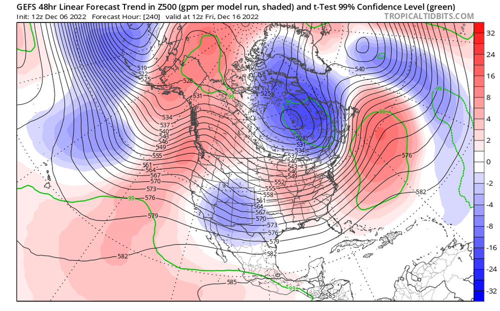
As @Weather Will shows there, 18z GEFS maintains more or less a similar look to 12z but more emphasizing the -EPO vs +PNA. All 3 ensemble systems have the -EPO in place by D8. D8 has more or less been our can kick point so that’s encouraging. Deeper into the runs they all get a cross-polar flow look as the EPO ridge goes across the AO domain. That will recharge Canada with very cold air if it happens eventually.
-
Maybe maybe not. The EPS pattern shown by @DarkSharkWX is “good” not “great”. More -EPO than +PNA and the ridging in the NAO is not a true block. But still a -AO. I’d certainly take it.
-
Lol you were saying?
-
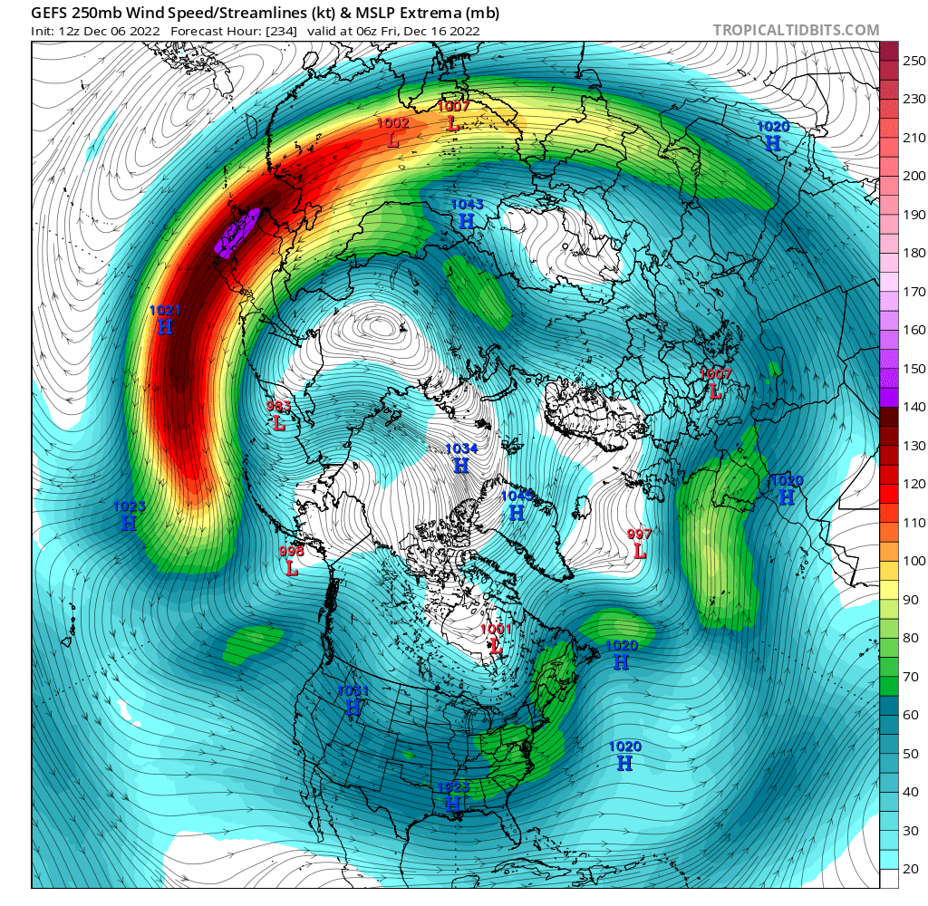
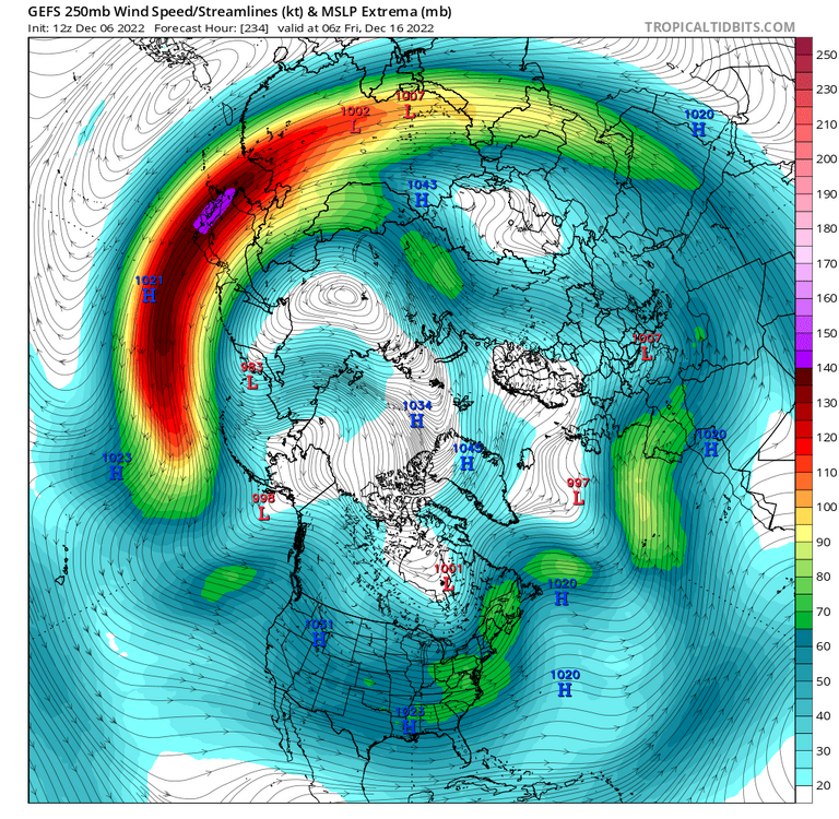
Wouldn’t shock me in the least Yes. GEFS still scours Canada free from most cold air, but that H5 look is light years better than it’s inverse. Yeah, I had to eyeball it as TT has no forecast trend plots for 250mb winds, but looked like a noticeable extension and strengthening after D7-8 on the 12z vs earlier runs.
-
Saw that! Bring it!
-
I’m on my phone so hard to post too many graphics but that forecast trend out west has totally flipped. It’s handling the Siberian PV a lot more like the eps. Seems to be all somewhat due to a much more extended Pac jet. Maybe due to an East Asian mountain torque event?
-
Lol just a few changes on the GEFS
-
^extrapolating a D13 KU there
-
These op GFS runs are just allergic to generating any legit cold air in North America and especially bringing any east of the Rockies. I miss the days of the always reliable D10+ blizzards.
-
Bingo
-
Follow up from above…if 1 runs trends are your thing (and we know they are!), 18z GEFS with more west coast ridging and moves the Siberian PV more into the Aleutians. Then it does it too much lol but one issue at a time .