WxUSAF
-
Posts
28,700 -
Joined
-
Last visited
Content Type
Profiles
Blogs
Forums
American Weather
Media Demo
Store
Gallery
Everything posted by WxUSAF
-
Some places got a legit dusting overnight
-
My grandmother lived in northwest Niagara county (the tiny light blue sliver on the map above). Worst microclimate for lake effect in western NY. As a kid, I’d get so excited for those huge events because I figured that guaranteed a white Xmas. Then my grandma would tell us she still has bare ground lol. Driving up there we’d pass through the eastern portion of the prime SW fetch Erie band and see enormous snow piles and deep snow and then quickly it would fade to brown frozen mud in Niagara county. The different microclimates are pretty fascinating.
-
If only it was after mid December or better yet in January…

-
Was just about to post that. Uncertainty the operative word. HH GFS has nothing except chilly dry weather. Post-Turkey pattern also showing uncertainty with some changes on the ensembles today.
-
Reminder to folks that we had a nice -NAO last December and we mostly torched. It can’t help us alone, especially outside of peak climo.
-
^that extended GFS is closer to the bad scenario I described yesterday. Siberian PV merges with the piece over the eastern Arctic ocean and we’re cutoff from fresh cold air. -NAO there keeps us from torching but that’s not a cold pattern. Modified PAC air rarely is sufficient for snow for us before January.
-
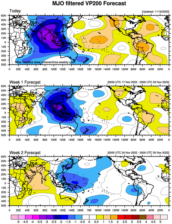
12z GFS and GGEM both have flavors of “cold high arrives” just in time. Except not in time for us and we get cold rain or chilly rain. But it’s worth watching. MJO from Mike Ventrice’s website shows a MJO progression that could lead to favorable west coast/AK ridging early-mid December. Phase 7-8 are cold for us in December.
-
The real cold air is scoured out ahead of this storm so we’re left with modified air which makes it tough anytime of year and especially in November. But I’ve seen a few op runs that have a fresh airmass nose in from the N/NE just in time, so maybe there’s a chance.
-
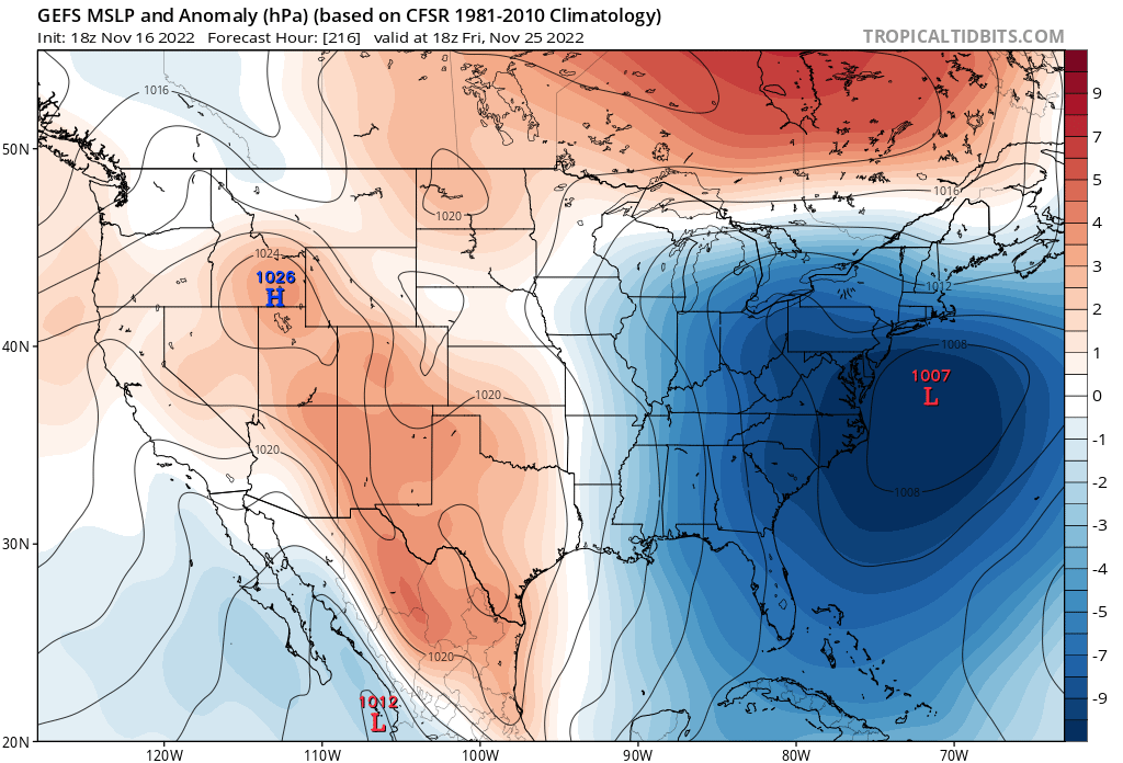
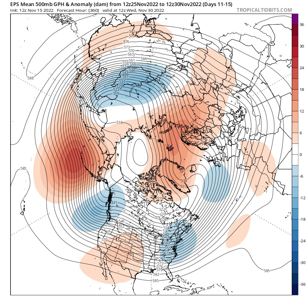
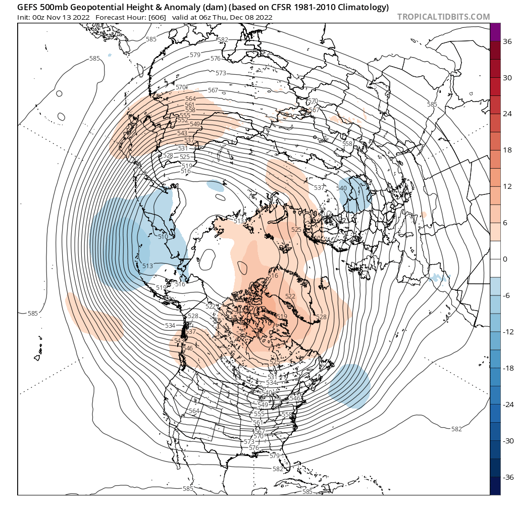
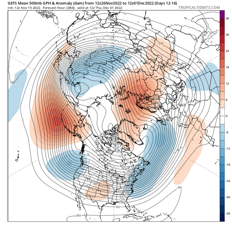
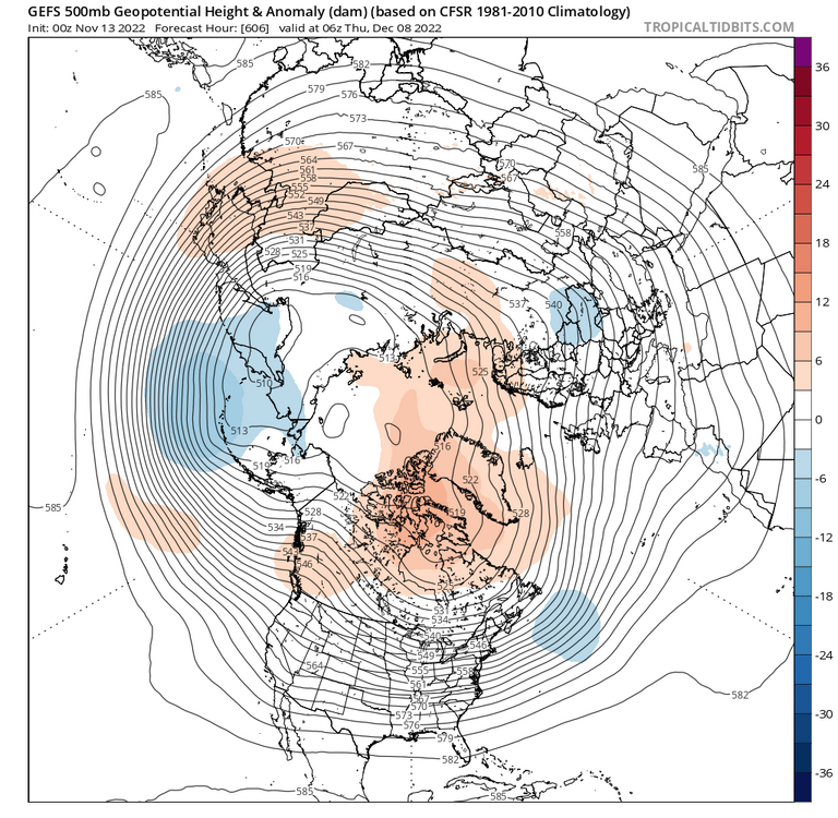
Models+ensembles have a pretty consistent depiction of the last 2 weeks of November. Cold and mostly dry after today through next ~Wednesday, some seasonable moderation for Thanksgiving/Black Friday and a day or two after, then perhaps one last cool/cold shot. After that we moderate, but perhaps not AN because of the -NAO nosing into Greenland and Baffin Island. The -PNA out west cuts us off from really frigid arctic air, but the -NAO could be enough to keep us near normal or slightly below. What happens after depends on 2 things I think. First, that PV over eastern Siberia. If you look on TT or Pivotal, you can see that PV moves east through Siberia throughout the D7-15 period. If it continues east toward Kamchatka, that should push the -WPO ridge back over Alaska into the -EPO domain. The extended GFS from Sunday showed this: With the PV in that location, ridging is forced over the west coast and AK. With the -NAO, that could give a pattern like @CAPE's CFS plots from yesterday. If that stops going east or it merges with another trop PV over the pole, that would cut us off from colder air with the AO going positive and the EPO staying positive as well. The second is maintaining the -NAO. If that sticks around (which it seems to want to do) and we keep the Pacific domain at least neutral to our interests, and that could set us up well by ~Dec 7 or so.

- 735 replies
-
- 24
-

-

-

-
Dark, 38F, rainy. Winter is here! Hot toddy for HH
-
Euro has some flurries/snow showers early Sunday as a reinforcing cold shot arrives.
- 735 replies
-
- 12
-
-
CWG winter outlook posted with major contributions from @Deck Pic. Looks reasonable to me.
-
Mrs. WxUSAF confirms. On the board for 2022-23!
-
November sun angle is a killer
-

2022 Mid-Atlantic Garden, Lawn, and Other Green Stuff Thread
WxUSAF replied to mattie g's topic in Mid Atlantic
I drag most of my leaves back to my fence line under our pine trees. They break down and it’s better ecologically. I can’t quite get to “leave the leaves” entirely, but I try to bag as little as I can. I mulch a lot of the rest.- 137 replies
-
- 1
-
-
- maters
- green stuff
- (and 5 more)
-
Historic Lake Effect Event?! 11/17-11/21
WxUSAF replied to BuffaloWeather's topic in Upstate New York/Pennsylvania
Good luck with this one folks! My grandmother lived north of Niagara Falls and as a kid I was always devastated when these types of events occurred and she would say she still had bare ground lol. -
Radiating well tonight. Down to 32-33 already.
-
^certainly possible places like Hagerstown could get a quick hit before a changeover. 18z guidance trended cooler across the board it looks like.
-
^that’ll do…seems like our current cold pattern holds into ~Thanksgiving or so, then we probably relax. If we reload (hi @leesburg 04!) by 10 December, we could be in good shape with conducive climo supporting snow events.
- 735 replies
-
- 10
-
-

-
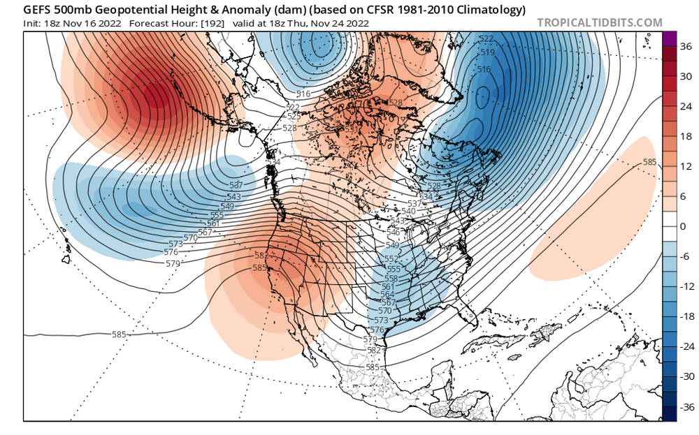
This seems…not bad? Most consistent feature is the NPac ridge, but most of the guidance has it oriented more over AK proper than the Aleutians and with it closer to the west coast. Hence the SE ridge is fairly muted in these looks and is more of a WAR. +AO though as well which isn’t ideal.
-
GFS and Icon say Saturday is the coldest morning. GGEM and Euro say Sunday. GGEM is kooky cold (it has low level temp issues), but euro is quite chilly also with widespread low 20s. Idea of a late weekend storm looks dead for now. On a different note, didn’t tropical tidbits have Euro weekly last year? I don’t see it now.
-
HenCo-HoCo death band is a really big band
-
2022 Mid-Atlantic Garden, Lawn, and Other Green Stuff Thread
WxUSAF replied to mattie g's topic in Mid Atlantic
With several hard freezes in the next week, growing season is over. I’ll mow once more to mulch leaves and cut the grass low so our dustings look nicer.- 137 replies
-
- 4
-
-
- maters
- green stuff
- (and 5 more)