WxUSAF
-
Posts
28,700 -
Joined
-
Last visited
Content Type
Profiles
Blogs
Forums
American Weather
Media Demo
Store
Gallery
Everything posted by WxUSAF
-

January Mid/Long Range Disco 3: The great recovery or shut the blinds?
WxUSAF replied to psuhoffman's topic in Mid Atlantic
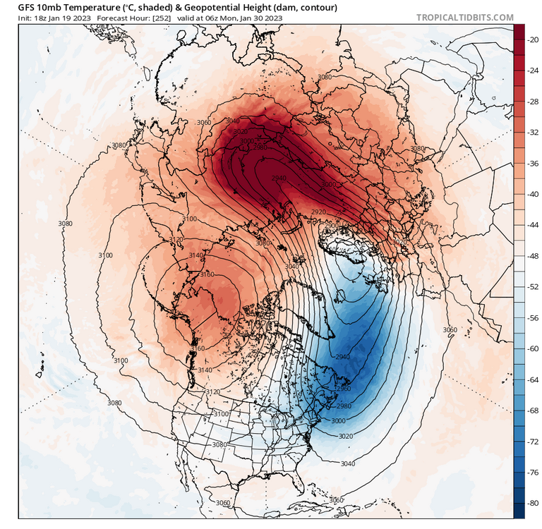
Interesting the GEPS likes midweek because the 12z GGEM finally loaded and cuts it west of Detroit. I think there’s still some hope for front end slop from that, but nothing more. Any substantial frozen-dominant system has to wait until after. -
January Mid/Long Range Disco 3: The great recovery or shut the blinds?
WxUSAF replied to psuhoffman's topic in Mid Atlantic
Even NCEP doesn’t want to overwrite that gorgeous D13 happy hour MECS -
January Mid/Long Range Disco 3: The great recovery or shut the blinds?
WxUSAF replied to psuhoffman's topic in Mid Atlantic
Is NCEP having issues? GFS/GEFS seems stuck on TT at least. -
January Mid/Long Range Disco 3: The great recovery or shut the blinds?
WxUSAF replied to psuhoffman's topic in Mid Atlantic
-
January Mid/Long Range Disco 3: The great recovery or shut the blinds?
WxUSAF replied to psuhoffman's topic in Mid Atlantic
The durable -NAO isn’t crazy. Ensembles keep correcting to more -NAO in the long range the last several days and in theory a strat PV disruption would reinforce it as well. -
January Mid/Long Range Disco 3: The great recovery or shut the blinds?
WxUSAF replied to psuhoffman's topic in Mid Atlantic
Exactly! SSWs never fail! -
That OC selection will say a lot about what they want to do with Lamar. Lot of folks speculating on internal promotion.
-
January Mid/Long Range Disco 3: The great recovery or shut the blinds?
WxUSAF replied to psuhoffman's topic in Mid Atlantic
That’s not that far off from what we’re getting in the week ahead. Just with less WAR I guess. Smarch is coming to save winter 22-23! -
January Mid/Long Range Disco 3: The great recovery or shut the blinds?
WxUSAF replied to psuhoffman's topic in Mid Atlantic
We have a thread for this!! -
Agreed. I don’t think there’s enough runway left to get to a solution that gives frozen precipitation to the metro corridor. Far N/W still in the game for something.
-
She has rain/snow for Sunday and next Wednesday with temps above freezing. Was emphasizing far N/W for Sunday obviously
-
January Mid/Long Range Disco 3: The great recovery or shut the blinds?
WxUSAF replied to psuhoffman's topic in Mid Atlantic
I’ll just blame the Ukie’s generally poor thermals -
January Mid/Long Range Disco 3: The great recovery or shut the blinds?
WxUSAF replied to psuhoffman's topic in Mid Atlantic
That’s either a very nice solution for us or one for @psuhoffmans notebook. -
January Mid/Long Range Disco 3: The great recovery or shut the blinds?
WxUSAF replied to psuhoffman's topic in Mid Atlantic
Schizophrenia -
January Mid/Long Range Disco 3: The great recovery or shut the blinds?
WxUSAF replied to psuhoffman's topic in Mid Atlantic
FWIW based on track alone, crazy uncle Ukie seems to be on a favorable camp for Sunday/Monday. -
January Mid/Long Range Disco 3: The great recovery or shut the blinds?
WxUSAF replied to psuhoffman's topic in Mid Atlantic
Euro’s a good hit for far N/W Sunday and already looking very different for the next week storm. -
January Mid/Long Range Disco 3: The great recovery or shut the blinds?
WxUSAF replied to psuhoffman's topic in Mid Atlantic
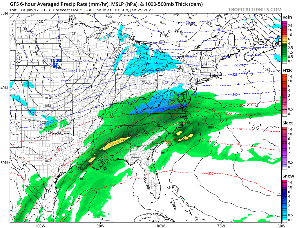
There have been plenty of signs in op runs and ensembles that we probably get a respectable arctic push from this pattern and both GGEM and GFS show it today. That probably means cold/dry for a couple days outside snow showers with the arctic front. Question then becomes if we can throw some moisture back over the cold air as the TPV retreats back to Canada. -
January Mid/Long Range Disco 3: The great recovery or shut the blinds?
WxUSAF replied to psuhoffman's topic in Mid Atlantic
Yeah, pretty big shift. Don’t think I’ve seen substantial digital blue for us within 100 hours yet this winter before today lol. -
January Mid/Long Range Disco 3: The great recovery or shut the blinds?
WxUSAF replied to psuhoffman's topic in Mid Atlantic
Kaiser starts off 12z well. Key to a coastal track seems to be a more northern stream dominated shortwave as 6z gfs and 12z icon show. -
January Mid/Long Range Disco 3: The great recovery or shut the blinds?
WxUSAF replied to psuhoffman's topic in Mid Atlantic
Good pull but let’s PLEASE not go down this path again in this thread -
January Mid/Long Range Disco 3: The great recovery or shut the blinds?
WxUSAF replied to psuhoffman's topic in Mid Atlantic
Guess we’ll be having our vodka warm -
The “is it ever going to snow again” discussion.
WxUSAF replied to psuhoffman's topic in Mid Atlantic
Fuck you gfs
-
January Mid/Long Range Disco 3: The great recovery or shut the blinds?
WxUSAF replied to psuhoffman's topic in Mid Atlantic
I saw the EPS snow map elsewhere and it’s probably the best I’ve seen since December? 6-7” for Harrisburg ranging down to ~3” for DC. -
January Mid/Long Range Disco 3: The great recovery or shut the blinds?
WxUSAF replied to psuhoffman's topic in Mid Atlantic
Weird evolution for the 25-26, but damn close to a MECS -
January Mid/Long Range Disco 3: The great recovery or shut the blinds?
WxUSAF replied to psuhoffman's topic in Mid Atlantic
Front end slop Sunday