

WxUSAF
-
Posts
28,779 -
Joined
-
Last visited
Content Type
Profiles
Blogs
Forums
American Weather
Media Demo
Store
Gallery
Everything posted by WxUSAF
-
Nope wrong thread for that ^^
-
ENSO forecasts are pegging a Nino developing, but they’re always iffy until later in spring. And yes, whether it’s east-based (Nino 1+2) or west-based (Nino 3+4) makes a difference for us, but Nino years in general are reliably our best snow years.
-
^that makes little sense
-

January/February Mid/Long Range Disco IV: A New Hope
WxUSAF replied to stormtracker's topic in Mid Atlantic
You should get a heat pump -
The “is it ever going to snow again” discussion.
WxUSAF replied to psuhoffman's topic in Mid Atlantic
He’s been on the underwater volcano thing for awhile now. Complete joke -
January/February Mid/Long Range Disco IV: A New Hope
WxUSAF replied to stormtracker's topic in Mid Atlantic
We got the GRAF -
January/February Mid/Long Range Disco IV: A New Hope
WxUSAF replied to stormtracker's topic in Mid Atlantic
Do you all really need twice daily reminders not to talk climate change in this thread? -
January/February Mid/Long Range Disco IV: A New Hope
WxUSAF replied to stormtracker's topic in Mid Atlantic
At least this time we made it to D5-6 with digital blue! Progress! At this rate, by late April we’re gonna cash in! -
We should probably just lock the whole board until April
-
January/February Mid/Long Range Disco IV: A New Hope
WxUSAF replied to stormtracker's topic in Mid Atlantic
Nope nope nope not going to talk about that -
January/February Mid/Long Range Disco IV: A New Hope
WxUSAF replied to stormtracker's topic in Mid Atlantic
If we strike out next week I’m probably ready for gusty shower season -
Just bumping the banter thread in case ya’ll lost it here as a pinned topic…
-
January/February Mid/Long Range Disco IV: A New Hope
WxUSAF replied to stormtracker's topic in Mid Atlantic
Conversation over thanks. You both can calm or excite your own tits with PMs if you want. -
January/February Mid/Long Range Disco IV: A New Hope
WxUSAF replied to stormtracker's topic in Mid Atlantic
Play nice kids -
January/February Mid/Long Range Disco IV: A New Hope
WxUSAF replied to stormtracker's topic in Mid Atlantic
I tend to agree and the chart time starts with a 1 instead of a 2 or 3! P.S. if I’m betting cutter vs suppressed, I’ll go with the seasonal trend for now. -
January/February Mid/Long Range Disco IV: A New Hope
WxUSAF replied to stormtracker's topic in Mid Atlantic
Come on little 1012mb low, push that arctic high!! -
January/February Mid/Long Range Disco IV: A New Hope
WxUSAF replied to stormtracker's topic in Mid Atlantic
It’s not 0z, but I’d take it in a hot minute -
January/February Mid/Long Range Disco IV: A New Hope
WxUSAF replied to stormtracker's topic in Mid Atlantic
GEFS has certainly been moving in a more favorable direction for the window around the 3rd with a much better located PNA ridge showing up in the last 24 hours.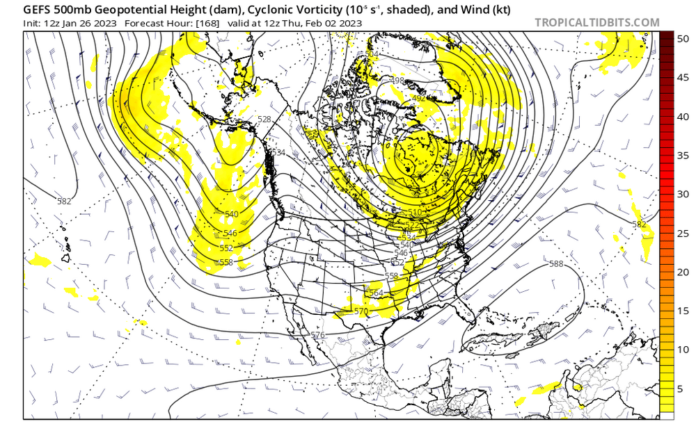
-
-
Wrong. #AllTenthsMatter
-
Rain and sleet in Greenbelt
-
January/February Mid/Long Range Disco IV: A New Hope
WxUSAF replied to stormtracker's topic in Mid Atlantic
GFS helpfully waits until the arctic air has nearly left before bringing up that slug of moisture. Meanwhile, NC and southern VA are turned into a ZR glacier. -
January/February Mid/Long Range Disco IV: A New Hope
WxUSAF replied to stormtracker's topic in Mid Atlantic
With a lot of juice on its tail and arctic air pressing… -
Repinning this. Near warning criteria snow already in Allegany county MD
-
“Tiny flurries” in Columbia per Mrs WxUSAF


