WxUSAF
-
Posts
28,578 -
Joined
-
Last visited
Content Type
Profiles
Blogs
Forums
American Weather
Media Demo
Store
Gallery
Everything posted by WxUSAF
-
Yeah…January 2022 was a solid winter month. Two events the first week, one warning and one high-advisory level, then the MLK day storm, and then a couple minor events.
-
It’s a joke
-
101 ensemble members guarantees that 1 will always show a HECS!
-
Oh yeah it’s beautiful. Areas north of Philly or even north of NYC obviously have a lot more wiggle room than us. Miller Bs suck for us usually because they form too far north. You can see on the euro that even with a low popping off Hatteras it takes time for it to develop a CCB precip shield and we get wraparound snow only. 50mi north shift there and it’s congrats Philly. 150mi and congrats Poconos or Catskills. Still…way better than no chance.
-
This scenario: cutter followed by northern stream Miller B is obviously a low-likelihood chance for us and nailing where any snow band forms will be a very dicey prospect…but a 10% chance is a helluva lot better than the 0% we had. And it’s only 4-5 days out.
-
@psuhoffman…12z GEFS says 3-4 days to flush PAC puke out of central Canada and replace it with BN temps after the PNA/EPO ridge pops.
-
Have to take a number and I already got number 001.
-
GGEM has a 4 county wide blizzard and gfs has a January hurricane. Your move, euro!
-
As good as the chiefs are, I think the afc comes down to the bills and bengals.
-
Agreed. Gives a shadow of a hope next week if the offense is healthy and somewhat functional.
-
Ravens might lose by 30+
-
If we get that tall coupled PNA and EPO ridge, it will build homegrown cold. It’s just physics. No WAA off the PAC coupled with low sun angle and radiating snow cover. Question is how fast and then how long to transport it south. You can probably do some sort of back of the envelope calculation on this… My intuition is something like 4-8 days to regenerate at least normal if not BN temps in central Canada, then another 3-5 days for southward transport. So if that ridge does develop with a trough in the east, maybe 6-7 days at least before you can fully flush the mild air out?
-
My eyeball 2C is that the GEFS has done very well with the longwave pattern beyond D8 this winter. Even better than the EPS several times. But the euro suite is absolutely kicking the GFS/GEFS ass with individual storms inside of D7-8.
-
Low of 26.
-
Low of 33. Will be at least January 8 before it gets below freezing IMBY in 2023.
-
Still a very Nino look. What a strange year.
-
18z NAM and 4 drinks and I feel a lot more zen about the euro/eps
-
HoCo deathband!!!
-
Damn…3k is sexy. I’m staying up late if that’s right so I can measure my max accumulation right before it starts to melt.
- 179 replies
-
- 12
-

-

-

-
I think this conversation is heading in directions that aren’t relevant to this thread or subforum quickly.
-
Good lord. Show me this image and tell me it’s mid-January with no other context and I’d get a @stormtrackeresque poke-your-own-eye-out pants tent.

-
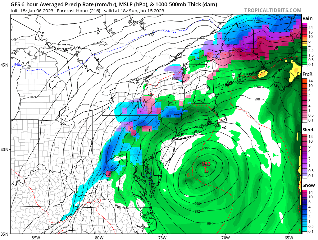
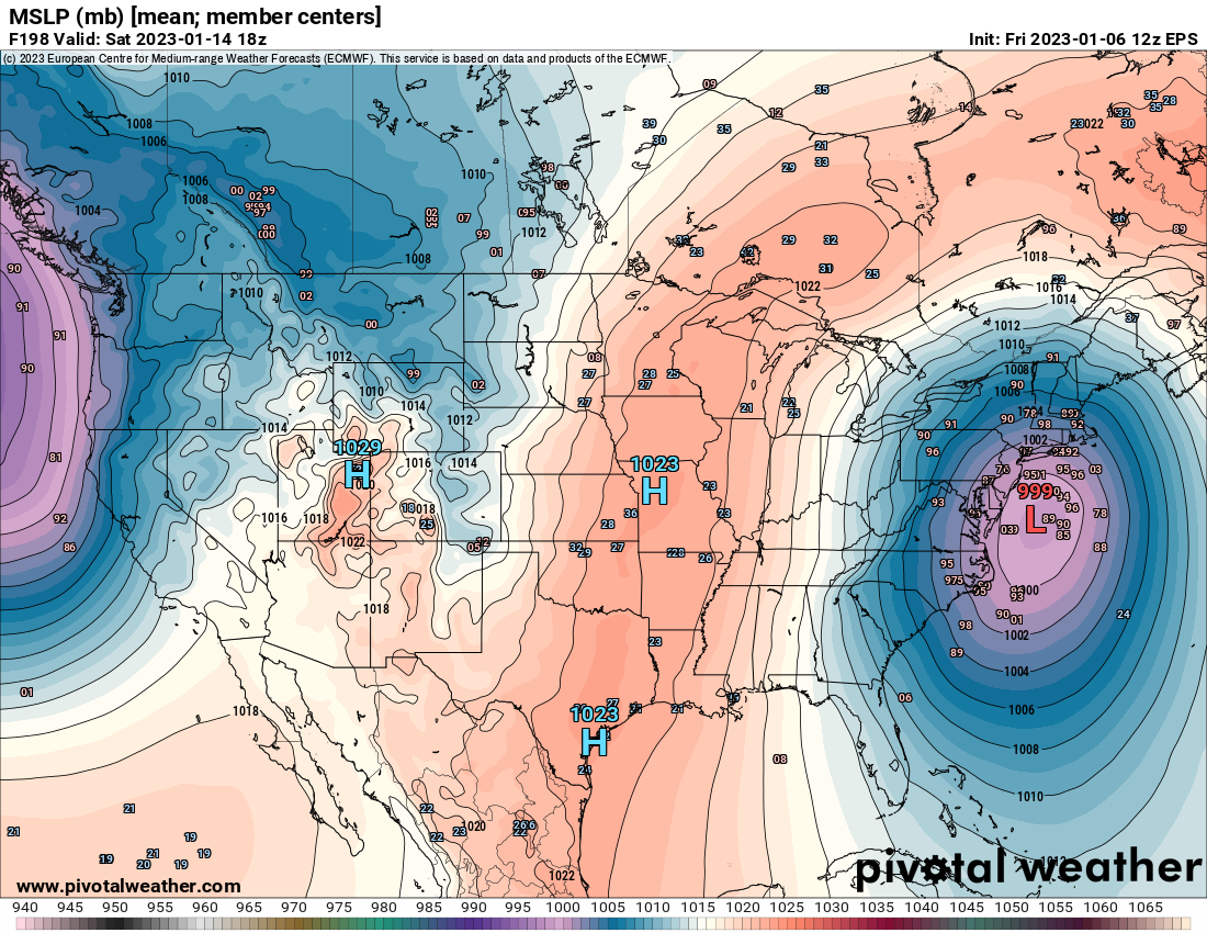
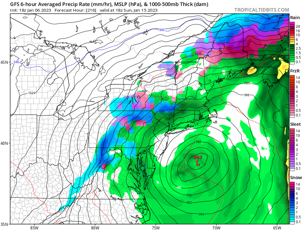
Sweet Jesus. Beating a dead horse here, but 12z eps has a 999mb low off Ocean City on the mean next Saturday! Damn perfection! Warm rain.
-
EPS playing follow the leader, at least in part. Whelp…12z started so well.
-
Thunderstorms to Montreal in mid January would be something.
-
I’m tossing it into the sun. Euro went from the most confluence to the least in a day.