

John1122
-
Posts
9,692 -
Joined
-
Last visited
Content Type
Profiles
Blogs
Forums
American Weather
Media Demo
Store
Gallery
Posts posted by John1122
-
-
wrong thread.
-
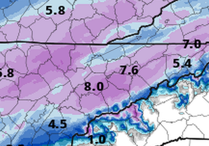
3k is at 15 inches over Cross/Frozen Head by hour 28. I'd guess it's really keying on upglide into the peaks there.
-
 3
3
-
-
Years ago there was an elk who was in the road by my house every day. TWRA came and put up a trap the size of a 5 horse trailer for it. They finally caught it and drove it all of three miles away and released it. The next day it was back. Now they only remove ones that are around the 4 lane in town that don't move on.
-
7
-
 1
1
-
-
Even though it benefits me the most, I truly hope the NAM isn't right for everyone else's sake.
-
I can already tell the 18z 3k NAM is going to go for 12-16 inches over Cross Mtn like it did at 12z. It's like a crazy ensemble member that skews the mean in how it skews the NBM.
-
7 minutes ago, Mrwolf1972 said:
18z hrr


Sent from my SM-S916U1 using Tapatalk
The ice in some areas is the precip ending as freezing drizzle as moisture falls below the DGZ. It happens fairly often in big snows but I don't recall seeing it in powdery snows. The sounding does say "best guess p-type as freezing drizzle in my area but I think the model is having issues, as two skew-t's within a mile or so of each other in my area are vastly different in the upper levels regarding temps.
-
1
-
-
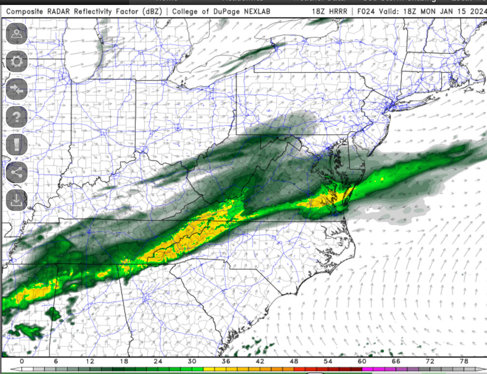
I believe this is the HRRR showing downsloping off Cross Mtn that affects things all the way into SW Va. Cross Mtn is 3300-3534ft in the area just left of the arrow start, and it quickly drops to around 1000 feet straight up the heart of Norris Lake there, though the lake is surrounded by 1300-1600ft ridges.
-
HRRR lee side low popping and keeping East Tennessee under convective snow showers.
-
2
-
-
Just now, fountainguy97 said:
Bright banding is always indicative of a phase change in the precipitation. It may not show on the ptype charts but the hrrr is mixing sleet/rain in for 3-5 hrs.

I believe it could be due to flake size. The snow will be much wetter in those areas. Those big flakes often cause that too.
-
Towards the 28-30 hour mark the HRRR is giving what almost looks like convective snow shower cells around the area.
-
The HRRR gives the entire state around 2+ inches except for the tiny SE corner of Polk Co. Imagine being a snowlover and living there.
-
1 minute ago, fountainguy97 said:
Lots of mixing on hrrr for eastern counties. To be expected at this point.
The soundings support snow all the way to the border. Very edges of the foothills have sub freezing column from 700 to the surface.
-
1 minute ago, Matthew70 said:
Yeah dewpoint 6 here. Thats not going to work for snow.
It will, you'll get some virga. West of you it's snowing with air temps lower than that and dps below 0.
-
1
-
 1
1
-
-
The HRRR appears to have heavy snow all the way to the NC border by HR 22. Chattanooga/N.GA are in all snow too.
-
1
-
-
4 minutes ago, fountainguy97 said:
Hrrr is trending toward that little bend in the precip shield that was not kind to Eastern areas on other models.
It's in the NAM family and maybe the same mechanics that are causing the NAM to be NW with the precip shield are what it's seeing.
The 15z SREF mean was in about the same arc too.
-
1
-
-
The dewpoints have crashed into oblivion in the mid-state. I wonder if that is having any effect on some lower QPF outputs for there.
-
1
-
-
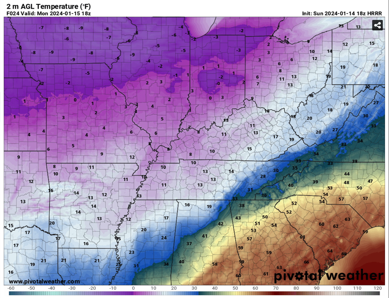
25 this morning and currently 34 degrees. The true Arctic air is over the Mid-State and hasn't made it to here yet.
-
2
-
-
The Euro initialized way too dry with the system vs real time obs. Eastern Ok. SE Kansas, NW Ark, SW Missouri are getting pounded right now. Grove in SE Kansas is reporting -9 degrees with heavy snow, vis .25 miles. The 12z Euro barely has them getting precip at this hour.
-
5
-
-
16 minutes ago, Holston_River_Rambler said:
Latest NBM ticked up quite a bit. 4 run trend:
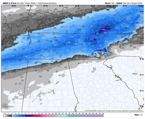
It ingested the NAM 3k for my area. There's some 18 inch areas between the two of us over Cross Mtn/Frozenhead/Brimstone.
-
3
-
-
As Jax noted, the HRRR is booking it. I've now got 4 digital inches on it by 5am tomorrow morning.
-
1
-
-
2 minutes ago, jaxjagman said:
Short range models look more faster with this system.HRRR even shows some mixing almost all the way to the Ky border but the thermal profiles dont support that
Not sure why but some of the models have been depicting p-types that aren't temp supported. Several have shown rain as the dominant p-type around the s/se side of the precip field but temps never getting out of the 20s while it shows it. I've never seen it before with model outputs.
-
2
-
-
23 minutes ago, Silas Lang said:
So...if this bias is showing in the short range models, does that mean some locations could possibly see something like 50% more snow than modeled? Goodness.
I look at it more as achieving what's modeled. I honestly take the snowfall maps and shave 30-40 percent off and expect that as actual snow accumulation. Occasionally you get to 100 percent or more, but it's way more common to get in that 60-70 percent range. That's more reasonable and why MRX says 3-6 inches with possible dollops of higher amounts.
-
2
-
-
4 minutes ago, Uncle Nasty said:
I don't mean to sound like a Debbie downer, but I've seen this set-up over the years bring major disappointment to snowlovers in Chattanooga. I'm cautiously optimistic we are on the cold side of the precip, but I can't help but be concerned about the lurking warm air nearby. What I'm seeing is Chattanooga (the southern area bordering Georgia) will be in the 34°-36° temperature range tomorrow for a good portion of the day. Atlanta might even reach 50°. We aren't that far from Atlanta. I would really hate to see the Arctic cold air stall just to our north and west and keep us mainly in a mixed bag of precip until the changeover.
All the pros on here, please correct me if I'm wrong, but I really do see that as a HUGE concern for Chattanooga.
Sent from my SM-S916U using Tapatalk
There are best and worse case scenarios for your area that are more extreme than most others. But to get the heaviest snow sometimes being right next to the change over to rain is best. Best case for you guys looks like the RGEM. It stays plenty cold and snows all over Hamilton Co even to the border. Worst case is the 3k NAM, but it's more in the way the precip lines up. I will say this in my experience. If you start off as snow in a situation like this, it's normally harder to change over to freezing rain/sleet because the Arctic air is seeping in more and more as the event takes place and the snow helps cool the column.
-
5
-
-
4 minutes ago, ShawnEastTN said:
Speaking of OBS, are we going to use this thread for OBS as well or new thread?
I prefer the same thread for everything but whatever anyone else wants. (I go back and read these during the off-season and like not having to go through multiple threads to get from predictions to results.)
-
4
-
1
-

January 15th-17th 2024 Arctic Blast/Snow Event
in Tennessee Valley
Posted
That seems early for that area but they will probably make a run at 5-7 inches.