

John1122
-
Posts
9,702 -
Joined
-
Last visited
Content Type
Profiles
Blogs
Forums
American Weather
Media Demo
Store
Gallery
Posts posted by John1122
-
-
Just now, Reb said:
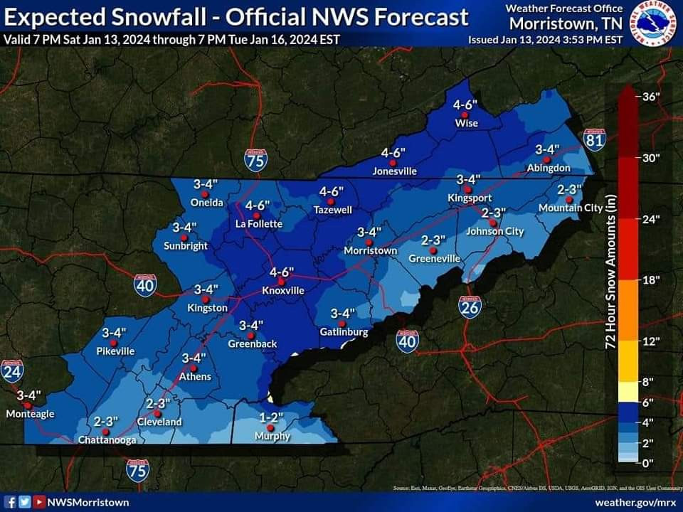
I saw this posted with other MRX graphics on Sevier County Emergency Mgmt Facebook page
Okay. It must be in the package they email to EMS directors.
-
Someone shared this post. It wasn't from MRX but one of those post the GFS at D12 and say it's going to snow pages. I've looked high and low on MRX socials and the web page and cannot find it. Did anyone else see it or did that page fake it.
-
9 minutes ago, bearman said:
What is the light snow coming in to West TN and Southern KY. associated with.

I think that's a frontal boundary that will reinforce cold air. That's why it's going to be colder tomorrow than today.
-
 3
3
-
-
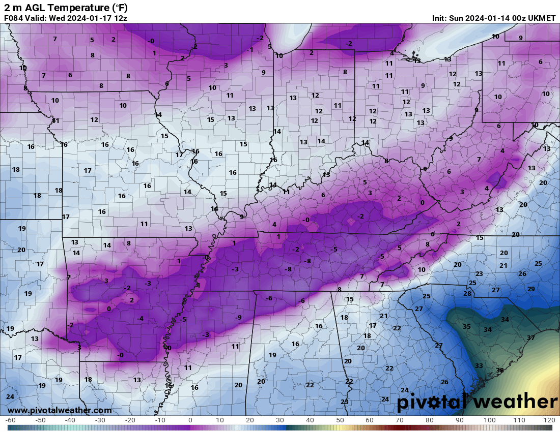
Brutal cold on the UKIE, seems like it used to be conservative/warm.
-
4 minutes ago, Wurbus said:
I wonder if the Ukie still has some mixing issues. It shows .9 QPF for KNX, but only 4" of snow
After looking, there's a warm nose at 925mb that puts Knox County above freezing above the surface for a bit. The ground temp is upper 20s while precip is falling. So there may be some sleet in there.
-
 1
1
-
-
Just now, Wurbus said:
I wonder if the Ukie still has some mixing issues. It shows .9 QPF for KNX, but only 4" of snow
Possibly. I can't see any precip type panels. It's been wound up and warm for a while.
-
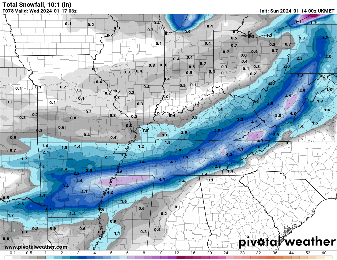
UKIE 10:1. Ratio'd should be better. It's came in line with other modeling.
-
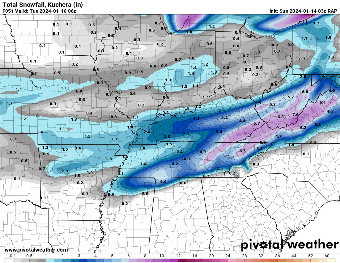
The RAP pops a low over SW NC and sends it N as that run ends.
-
1
-
-
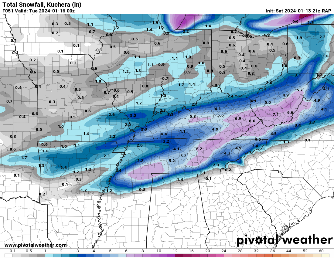
Latest model run, 03z RAP. Still snowing 75 corridor and East as of this frame.
-
1
-
-
The WVLT mets did have the infamous "melting into puddles will keep accumulation way down" in regards to I think the March 2022 event.
-
1
-
-
8 minutes ago, Jesse from KY said:
Thoughts on WFO Jackson's discussion this afternoon? It appears they aren't too excited about the potential for Eastern Kentucky? I hope their thinking changes. I soo want a good snow for SE KY
Key Messages:

* An arctic airmass will be in place at the start the work week,
  with daily highs from Monday through Wednesday expected to
  remain at or below freezing. Tuesday morning will drop close to
  zero, or possibly below zero depending on our snow cover.
  Temperatures will moderate above freezing on Thursday before a
  second, reinforcing round of arctic air arrives at the end of
  the period.

* There is a chance for accumulating snow Monday through Tuesday
  and possibly again later in the week. At this time confidence
  remains low on exact amounts. Areas generally south of the
  Mountain Parkway and Highway 80 appear to have the best
  opportunity of seeing accumulating snow. However, overall
  trends have taken snowfall accumulations further south and
  towards lower amounts.

Analysis and Discussion:

Our pattern remains active and highly amplified, with a Hudson
Bay low drifting slowly southward to the Great Lakes Region by the
end of the extended portion of the forecast. This will keep a
mean trough and unseasonably cold air in place across the eastern
CONUS. Relatively weak mid/upper level disturbances will round the
base of the mean trough with eastern Kentucky just within the
corridor of influence of these series of disturbances.

The first of these features within the extended period will
transit the Commonwealth Monday through Tuesday. Precipitation
will develop across the area as a result of weak isentropic lift.
Surface features with this first disturbance are not even
recognizable, providing insight into just how weak this system
will be. At this time there appears to be enough energy to
generate a swath of light snow with eastern Kentucky on the
northern fringes of this systems influence. Trends in run to run
solutions have taken snowfall accumulations further south and
towards lower amounts overall. At present, ensemble probabilistic
snowfall amounts suggest a high probability (> 70%) of an inch or
more along and southeast of a Monticello-Jackson- Paintsville line
with the first system. Probabilities drop rapidly for higher
amounts, with average probabilities of 3 inches or more generally
below 50%, with highest probabilities in along the KY/VA state
line.

The second system basically impacts eastern Kentucky Thursday
night through Friday night. This second system is quite similar to
the first, but appears a little stronger with some weak surface
features appearing in the solutions. As is typical, the only sure
bet is that things will change with time, and it remains to be
seen exactly how much winter precipitation is produced with the
second disturbance, if any.

These are weak systems, which make it a bigger challenge when
trying to forecast detailed sensible weather. However, we can
take some confidence that in general, we are in a pattern that
favors the opportunity of wintry weather, with our forecast area
in the northern, colder sections of these transient disturbances.
Thus odds should be in our favor that a system will eventually
produce a decent round of wintry weather.
According to how far north you live, looks like you're probably good for 1 to 4+ inches. But the story isn't written yet, I don't believe. There's gonna be someone close to an edge north and south that sees snow a few miles away but doesn't get much.
-
2
-
-
3 minutes ago, Icy Hot said:
I’ll take that 5.2 in Colonial Heights thank you very much. What’s the latest you think models will continue to change? Sunday PM?
It was actually still snowing over East Tennessee at the end of the run.
-
2
-
-
-
59 minutes ago, ShawnEastTN said:1 hour ago, John1122 said:18z RRFS A. Has tons of BL issues in the East. The winter weather is still unfolding at this point.
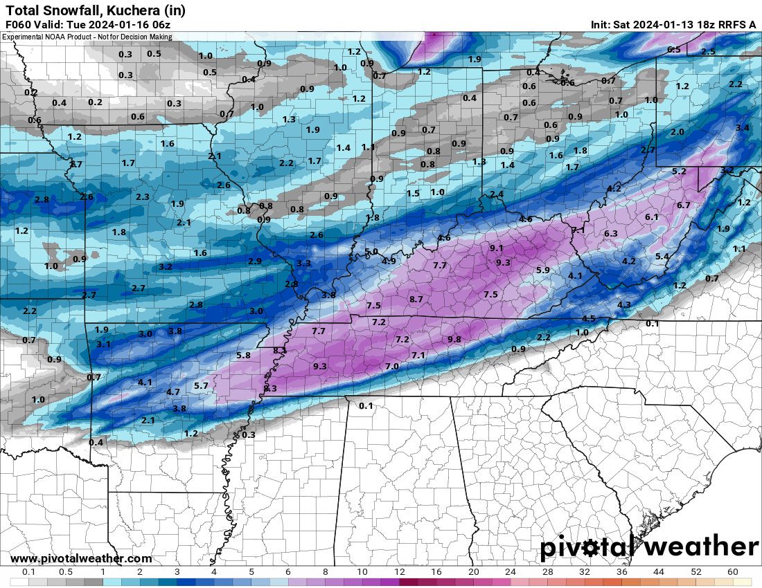
I really like the thickness of the accumulation area with this model. Isn't this going to replace a few other models eventually including HRRR?
Yes. It's the new NAM too.
-
2
-
-
18z RRFS A. Has tons of BL issues in the East. The winter weather is still unfolding at this point.
-
1
-
1
-
-
52 minutes ago, Knoxtron said:
Man, reading this forum leading up to an event is peak happiness haha
I'm sorry if this is basic, but when it comes to snow ratios... does elevation matter in this scenario?
I'm at 2100', but I assume the snow formation (?) zone is well above me and ground temps control what precip type arrives versus any type of ratio
It doesn't, in my experience. Elevation usually is a factor in marginal surface temp set ups. March 22 saw 10-12 inches here and elevation made no difference that I could tell. We were very cold throughout.
The DGZ does get to the ground here when it's below 0. You'll see ice crystals filling the air even when the sky is clear.
-
4
-
-
The GFS starts out the same as the hi-res models but narrows the QPF field way more than they do as the run wears on. Not sure why that is.
-
1
-
-
The GFS QPF field move N/NW about as much as the RGEM. The same area of N.GA that went from .4 QPF to .1 on the RGEM also did on the GFS. We're talking 25-40 miles. Basically a county width or so.
-
2
-
-
1 minute ago, Uncle Nasty said:
There's too many damn models to choose from. I was on another forum earlier, and people were arguing about which model was the best. The model that showed the most snow for their area was the best.

With that said, models are just tools used for guidance. We'll either get very little or get a great southern snow. Models are just an educated guess. Let's see what old Mama Nature has in store for us regarding a blanket of white on the ground for everyone.
I appreciate all the PBP and write-ups from all you knowledgeable folks!
Sent from my SM-S916U using Tapatalk
With how it goes around here, the actual worst one is usually the one that shows the most snow!
-
2
-
-
The RGEM precip field moved NW about as much as the NAMnest moved SE.
-
Congrats
3 minutes ago, *Flash* said:I just want to cash out on the 18z Icon. Too good to be true, I know.
It's literally been that exact same run from like 140 hours til now around 70.
-
The RGEM is rocking Knox area as it's right on the edge of the mix/zr/sleet.
-
1
-
-
Yes, the RGEM is about 2 counties north of where it was at 12z with its qpf field. North Georgia went from .4 qpf to .1.
-
RGEM looks a little north of 12z.
January 15th-17th 2024 Arctic Blast/Snow Event
in Tennessee Valley
Posted
The Euro basically stayed the same. It's on the southern edge of guidance still with the NAM on the northern. Everything else is basically in the middle of both. It keeps the narrow snow footprint.