

John1122
-
Posts
9,697 -
Joined
-
Last visited
Content Type
Profiles
Blogs
Forums
American Weather
Media Demo
Store
Gallery
Posts posted by John1122
-
-
2 minutes ago, jaxjagman said:
Short range models look more faster with this system.HRRR even shows some mixing almost all the way to the Ky border but the thermal profiles dont support that
Not sure why but some of the models have been depicting p-types that aren't temp supported. Several have shown rain as the dominant p-type around the s/se side of the precip field but temps never getting out of the 20s while it shows it. I've never seen it before with model outputs.
-
 2
2
-
-
23 minutes ago, Silas Lang said:
So...if this bias is showing in the short range models, does that mean some locations could possibly see something like 50% more snow than modeled? Goodness.
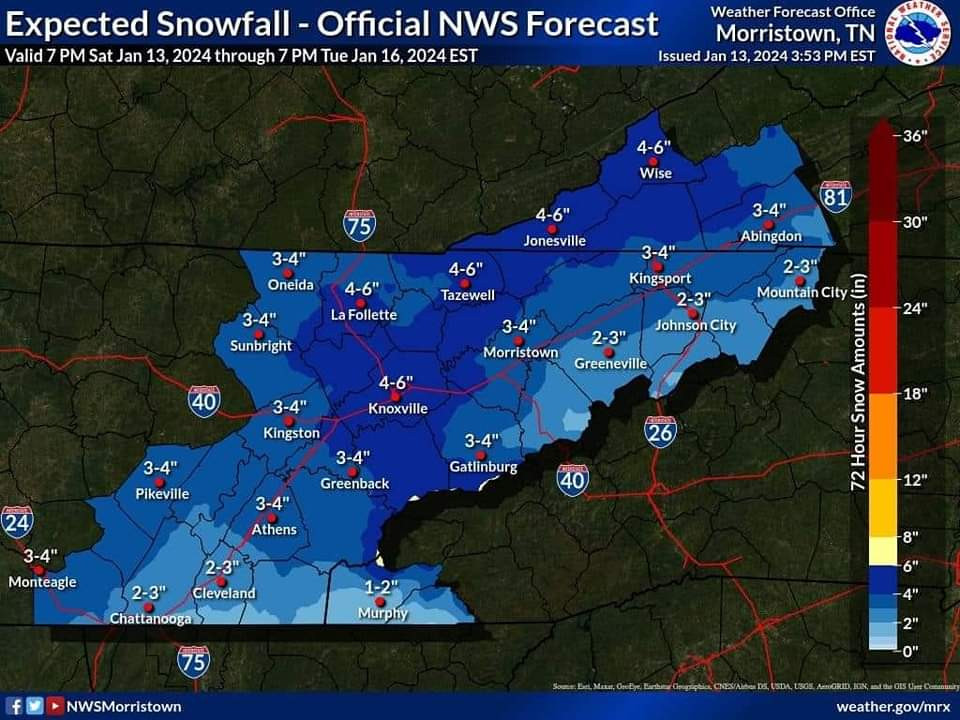
I look at it more as achieving what's modeled. I honestly take the snowfall maps and shave 30-40 percent off and expect that as actual snow accumulation. Occasionally you get to 100 percent or more, but it's way more common to get in that 60-70 percent range. That's more reasonable and why MRX says 3-6 inches with possible dollops of higher amounts.
-
2
-
-
4 minutes ago, Uncle Nasty said:
I don't mean to sound like a Debbie downer, but I've seen this set-up over the years bring major disappointment to snowlovers in Chattanooga. I'm cautiously optimistic we are on the cold side of the precip, but I can't help but be concerned about the lurking warm air nearby. What I'm seeing is Chattanooga (the southern area bordering Georgia) will be in the 34°-36° temperature range tomorrow for a good portion of the day. Atlanta might even reach 50°. We aren't that far from Atlanta. I would really hate to see the Arctic cold air stall just to our north and west and keep us mainly in a mixed bag of precip until the changeover.
All the pros on here, please correct me if I'm wrong, but I really do see that as a HUGE concern for Chattanooga.
Sent from my SM-S916U using Tapatalk
There are best and worse case scenarios for your area that are more extreme than most others. But to get the heaviest snow sometimes being right next to the change over to rain is best. Best case for you guys looks like the RGEM. It stays plenty cold and snows all over Hamilton Co even to the border. Worst case is the 3k NAM, but it's more in the way the precip lines up. I will say this in my experience. If you start off as snow in a situation like this, it's normally harder to change over to freezing rain/sleet because the Arctic air is seeping in more and more as the event takes place and the snow helps cool the column.
-
5
-
-
4 minutes ago, ShawnEastTN said:
Speaking of OBS, are we going to use this thread for OBS as well or new thread?
I prefer the same thread for everything but whatever anyone else wants. (I go back and read these during the off-season and like not having to go through multiple threads to get from predictions to results.)
-
4
-
 1
1
-
-
18 minutes ago, fountainguy97 said:
Rufus!!
Sounds solid to me. Rufus it will be from me. For some reason typing RRFS A is way annoying to me fingers.
-
44 minutes ago, PowellVolz said:
I was counting on 14:1 north of 40 in ETn. Is that too steep?
.It looks like it in counties that touch 40 in East Tn and points south. The globals are the best case scenario, giving 12/13:1 over those areas but it lowers into the 10:1 range as the day wears on. The Canadian/GFS look similar. The hi-res models seem to see more warmth but it may be a bias with them. At one point on the NAM your area has 11:1 ratios and McGhee-Tys is closer to 7:1.
-
4
-
-
Some form of system for that time frame, only the GFS is truly rolling big with it for now. The Euro was an Apps runner but we know the trend is SE this year vs the early runs. This current event was much further NW too when it started showing up.
-
3
-
-
12z RRFS A (really need a nickname for this)
-
2
-
1
-
-
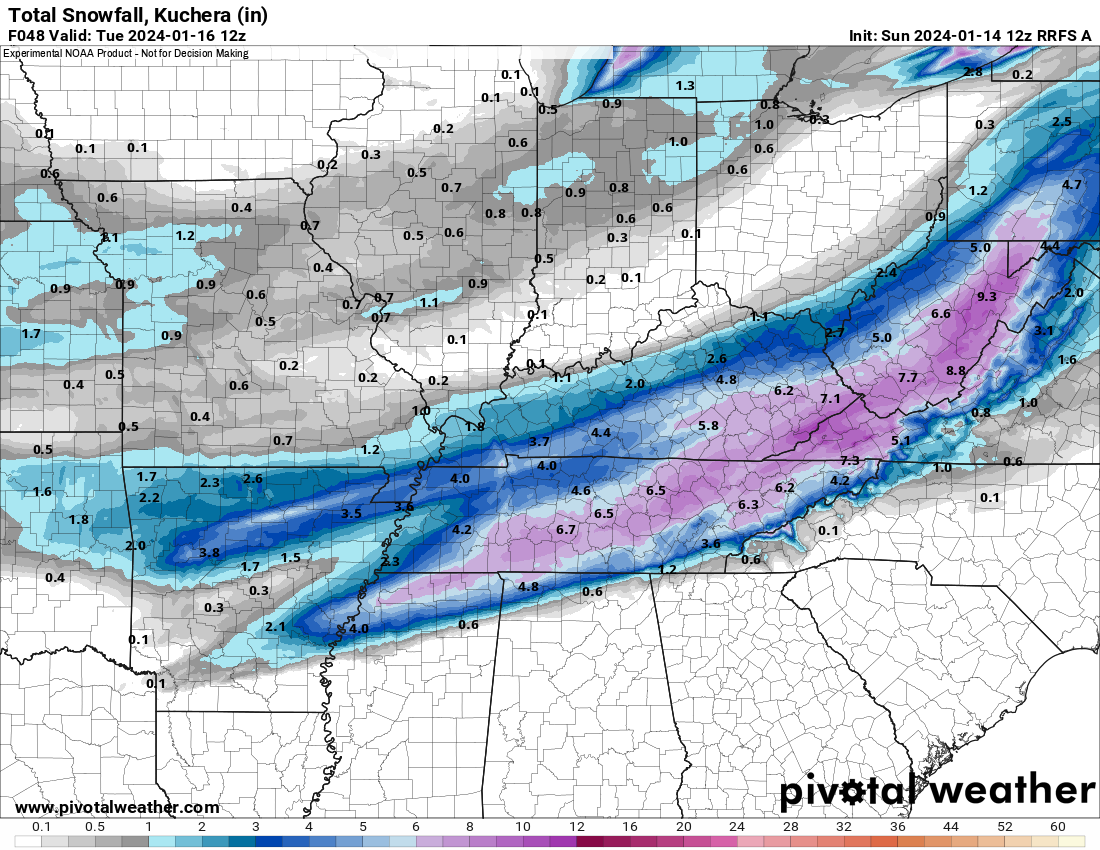
There's a stark ratio contrast from N to S across East Tennessee. It's less so the further west you go. I generally hover around 14:1 through the event. 11:1 around I-40 but it gets as low as 5:1 in Northeast Alabama and NWGa.
-
For looking back purposes.
-
9
-
2
-
-
MRX says no p-type issues anywhere except Georgia border areas.
-
1
-
1
-
-
2 minutes ago, TellicoWx said:
6z RGEM joins the HRRR
That was a blockbuster on the RGEM.
-
2
-
-
MRX has added the wording "moderate snow accumulation possible" to my forecast for next Thursday night already. That's normally their vernacular for 2-4 inches.
-
4
-
-
My forecast says 1 inch Sunday night, 2-4 Monday, and "Moderate Snow Accumulations Possible" Monday night. That usually means 2-4 inches as well.
-
I take that back. The NAM was colder over Knox Co and didn't have the p-type issues so instead of 3.5 inches Knox was covered by 7+ inches on the 12k. The 3k still has the p-type issues along and S of 40.
-
NAM pretty much stayed the same as 00z, 3k looks like it will too. NW edge of guidance for them. Especially the 3k.
-
1
-
-
3 minutes ago, TellicoWx said:
6z HRRR..and still has quite finished up and end of the run
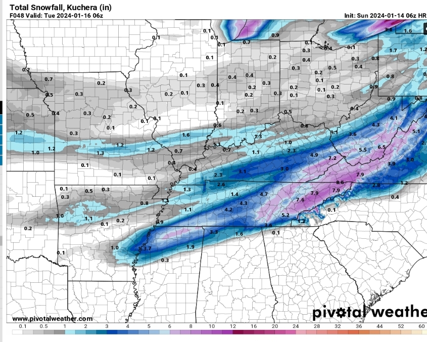
It snows forever on there.
-
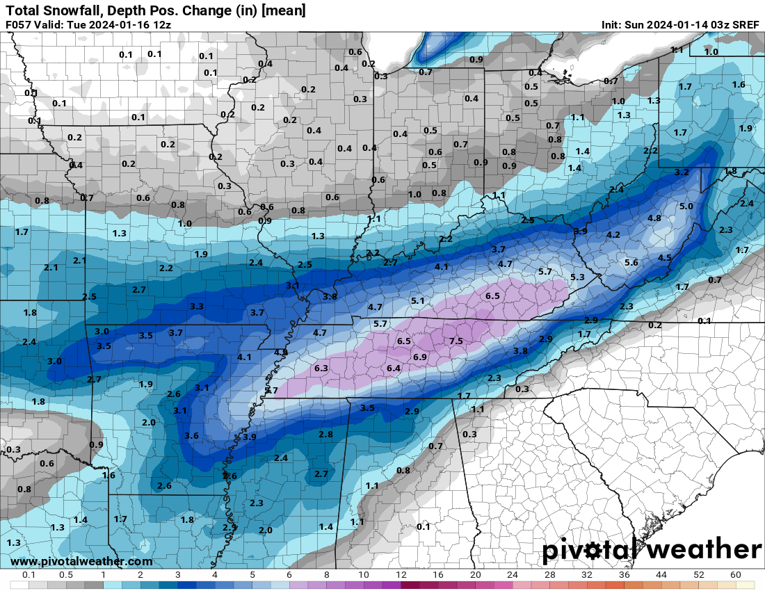
SREF snow depth mean change. This is pretty impressive for a mean for snow depth.
-
2
-
-
The 03z SREF is maintaining roughly the same snow foot print as earlier runs. That probably means the NAM will stay on the northern edge of guidance.
-
The Euro basically stayed the same. It's on the southern edge of guidance still with the NAM on the northern. Everything else is basically in the middle of both. It keeps the narrow snow footprint.
-
Just now, Reb said:
I saw this posted with other MRX graphics on Sevier County Emergency Mgmt Facebook page
Okay. It must be in the package they email to EMS directors.
-
Someone shared this post. It wasn't from MRX but one of those post the GFS at D12 and say it's going to snow pages. I've looked high and low on MRX socials and the web page and cannot find it. Did anyone else see it or did that page fake it.
-
9 minutes ago, bearman said:
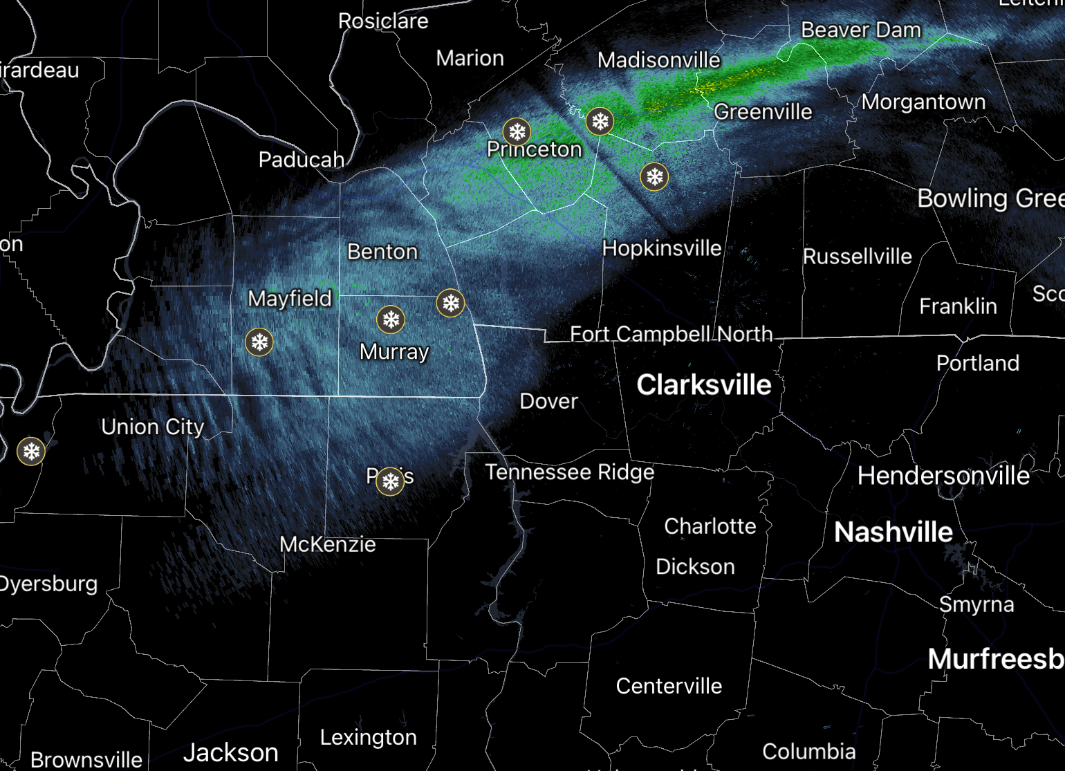
What is the light snow coming in to West TN and Southern KY. associated with.

I think that's a frontal boundary that will reinforce cold air. That's why it's going to be colder tomorrow than today.
-
3
-
-
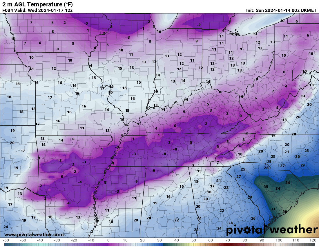
Brutal cold on the UKIE, seems like it used to be conservative/warm.
January 15th-17th 2024 Arctic Blast/Snow Event
in Tennessee Valley
Posted
As Jax noted, the HRRR is booking it. I've now got 4 digital inches on it by 5am tomorrow morning.