

John1122
-
Posts
10,740 -
Joined
-
Last visited
Content Type
Profiles
Blogs
Forums
American Weather
Media Demo
Store
Gallery
Posts posted by John1122
-
-
The 0z NAM was a massive improvement over any run so far. The 3k looks similar at the end.
-
 2
2
-
-
1 minute ago, Chattownsnow said:
Actually looking at modeling it’s not that big a difference in our neck of the woods. Really just noise, maybe slight down tick over all. Reading the doom and gloom in another forum I checked for myself and it’s just all IMB worries and not so much over all picture. Models are flopping around further west though. 18z Euro though looks rough though
The Euro went from .6 or so to .15 QPF in the last 24-36 hours. Just horrible luck and I've no doubt it's going to be correct because whatever is the worst case here, has been correct this winter.
-
1
-
 1
1
-
-
The Euro is a desert. Saw this story before. Basically whatever the worst case scenario is for snow in the area there's a 90 percent chance it happens here. Record breaker in the gulf, no issue. 5 inch snow in East Tennessee, hold your horses.
-
3
-
-
I hadn't looked out, I have a dusting of snow now with a decent rate falling. 29 degrees.
-
6
-
-
Steady small flakes falling, 30 degrees.
-
ICON looks good still. At least not like the NAM at all.
-
4
-
-
Power finally came back on. RGEM still looks solid.
-
6
-
-
It's wild how we used to have a Miller A system nearly every year and the last few years we can't buy anything but hand-off systems unless it's too warm to snow.
Hopefully we see some better trends in the next 36 hours, instead of worse trends.
-
2
-
1
-
-
Major flooding here and no power since around 3am as the storms moved in. Many roads cut in half, driveways gone. Trees down everywhere.
-
 3
3
-
-
Snowing here for the past hour. Power has been out since early this morning. Roads are washed away and the NAM pulls that crap. Hopefully it's just being a screwball.
-
2
-
2
-
-
The ICON and GFS went up on totals at 6z, and because we can't have simple, nice things anymore when it comes to winter weather, the Euro went down.
-
3
-
-
The Euro was a double bad draw for the areas in the Central Valley of East Tennessee and NE. It shoots a big warm nose up the middle of the valley with mid to upper 30s, and it cut QPF for the same area of the warm nose. It was about .15 to .25 less qpf vs 12z. The EPS is still a little wetter than the OP. But it's getting close to the time where the OP will likely handle things better. As I said, hopefully this is not a trend and we get a little more QPF to work with. It's pretty sad that we get 7 inches of rain in 4 days when it's warm, but can't be .5 when it's cold enough to snow.
-
Euro backed off with QPF, unfortunately. Still a ways to go, but hopefully not a trend. Most modeling backed off a bit tonight for Tennessee and upped totals in NC.
-
Canadian crept south a bit and now has the entire state over an inch, when 12z blanked some of the southern border areas.
-
4
-
-
GFS was fairly similar to 18z. Little heavier out west, a little lighter in the eastern valley after what looked like a promising start. Likely doing the hand-off thing Carvers talked about JB saying it does at times.
-
The temp has went up from 39 to 56 since 5pm. Heavy mist/drizzle going on out there. If that next line of storms/rain doesn't weaken, we're probably looking at some potentially life-threatening flooding for folks.
-
1
-
2
-
-
The NBM for the 12z suite would see a Winter Storm Watch criteria for SW Va, SE KY and areas along the Tennessee/Kentucky/VA border, dropping down towards 40 in the Mid-State and points West.
-
4
-
-
The NAM is amped (of course) and has the rain up to 40. The ICON was another good pass/run. The RGEM looks like it was going to be similar to the ICON/EURO etc.
-
3
-
-
TNC005-017-079-183-160230-
/O.CON.KMEG.TO.W.0008.000000T0000Z-250216T0230Z/
Weakley TN-Benton TN-Carroll TN-Henry TN-
757 PM CST Sat Feb 15 2025...A TORNADO WARNING REMAINS IN EFFECT UNTIL 830 PM CST FOR
SOUTHEASTERN WEAKLEY...NORTHERN BENTON...NORTHERN CARROLL AND HENRY
COUNTIES...At 757 PM CST, a severe thunderstorm capable of producing a tornado
was located near Paris Landing State Park, moving northeast at 50
mph.HAZARD...Tornado and ping pong ball size hail.
SOURCE...Radar indicated rotation.
IMPACT...Flying debris will be dangerous to those caught without
shelter. Mobile homes will be damaged or destroyed. Damage
to roofs, windows, and vehicles will occur. Tree damage is
likely.Locations impacted include...
Paris, McKenzie, Huntingdon, Paris Landing State Park, Dresden,
Gleason, Atwood, Cottage Grove, Routon, Vale, Springville, Trezevant,
Puryear, Big Sandy, Henry, McLemoresville, Sandhill, Mansfield, Old
Springville, and Como.PRECAUTIONARY/PREPAREDNESS ACTIONS...
TAKE COVER NOW! Move to a storm shelter or an interior room on the
lowest floor of a sturdy building. Avoid windows. If you are
outdoors, in a mobile home, or in a vehicle, move to the closest
substantial shelter and protect yourself from flying debris.&&
LAT...LON 3595 8865 3601 8870 3606 8869 3618 8873
3636 8853 3650 8834 3650 8806 3647 8805
3644 8806 3635 8798 3627 8794 3622 8795
3621 8794
TIME...MOT...LOC 0157Z 238DEG 44KT 3640 8812TORNADO...RADAR INDICATED
MAX HAIL SIZE...1.50 IN
-
1
-
-
BULLETIN - EAS ACTIVATION REQUESTED
Tornado Warning
National Weather Service Memphis TN
749 PM CST Sat Feb 15 2025The National Weather Service in Memphis has issued a
* Tornado Warning for...
Northwestern Henderson County in west Tennessee...
Southeastern Gibson County in west Tennessee...
Northwestern Hardeman County in west Tennessee...
Southwestern Carroll County in west Tennessee...
Southeastern Haywood County in west Tennessee...
Madison County in west Tennessee...* Until 830 PM CST.
* At 749 PM CST, a severe thunderstorm capable of producing a tornado
was located near Mercer, or 10 miles southwest of Jackson, moving
northeast at 50 mph.HAZARD...Tornado and quarter size hail.
SOURCE...Radar indicated rotation.
IMPACT...Flying debris will be dangerous to those caught without
shelter. Mobile homes will be damaged or destroyed.
Damage to roofs, windows, and vehicles will occur. Tree
damage is likely.* Locations impacted include...
Jackson, Humboldt, Lexington, Fairview, Three Way, Bemis, Blue
Goose, Bargerton, Mercer, Parkers Crossroads, Carroll, Medina,
Hickory Flat, Neely, Cedar Grove, Huntersville, Beech Bluff,
Westover, Madison Hall, and Uptonville.-
1
-
-
18z Euro was another nice hit from Kentucky down to Northern Bama. Nice EPS too. As good as the 12z.
-
7
-
-
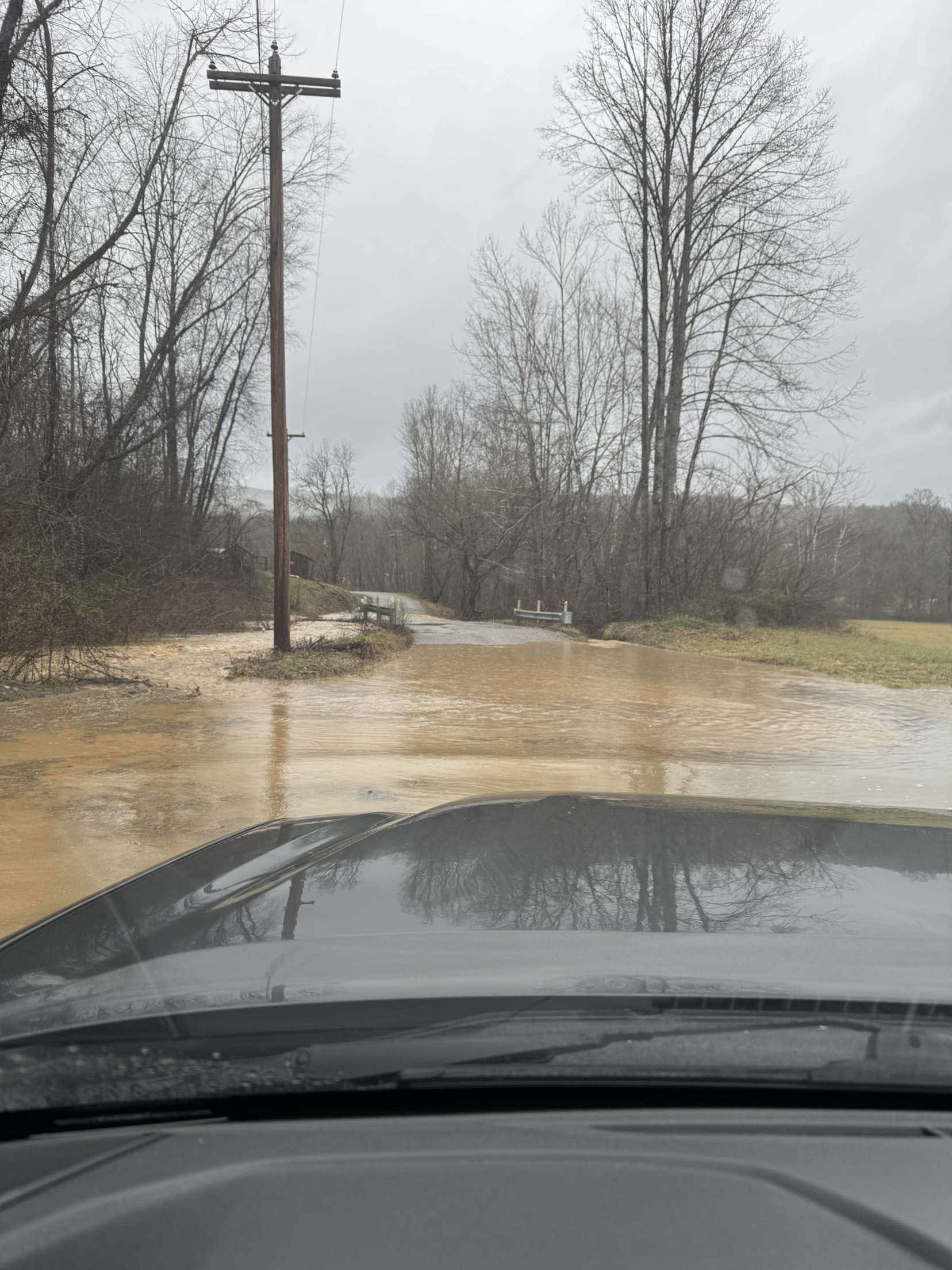
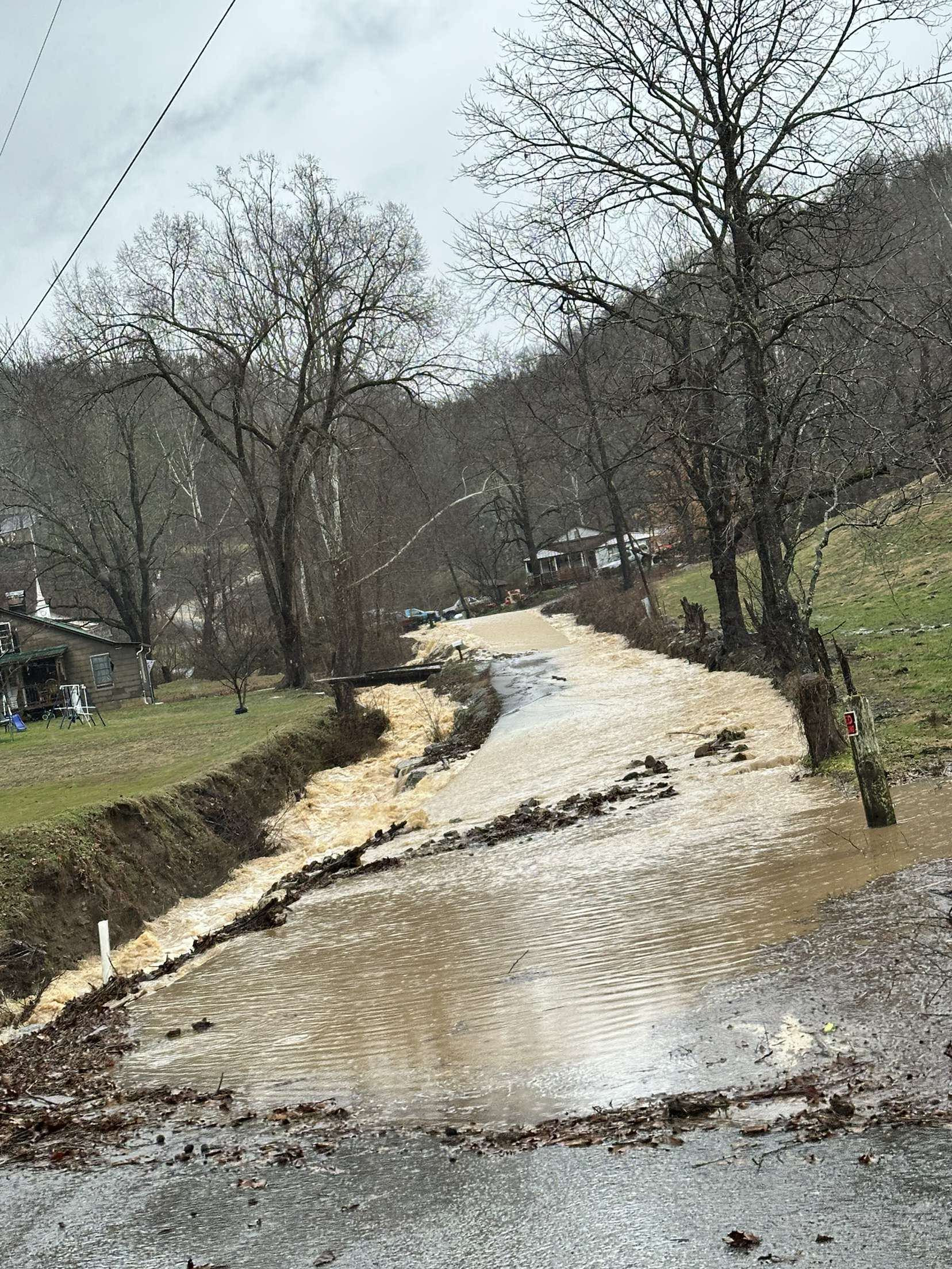
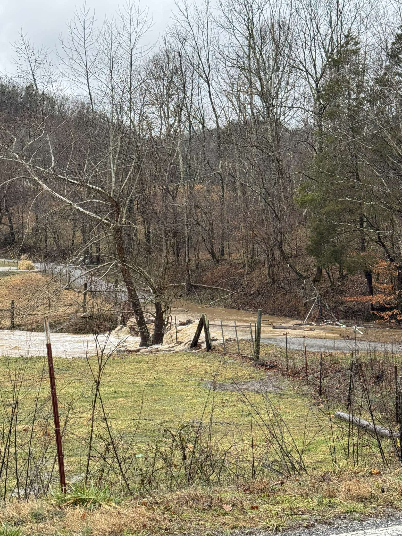
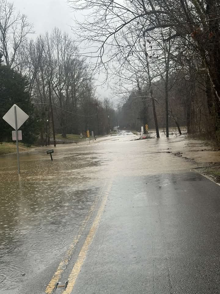
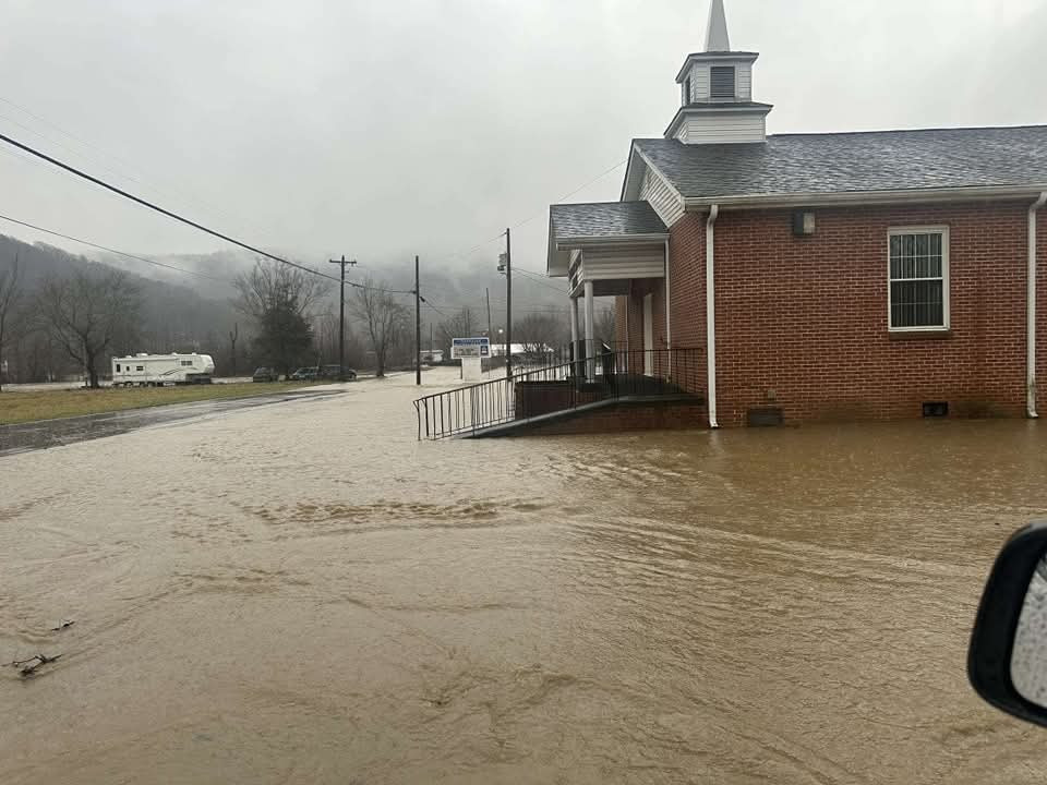
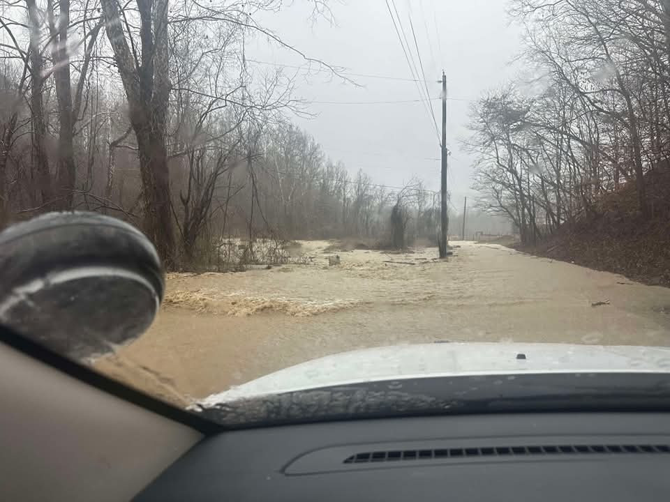
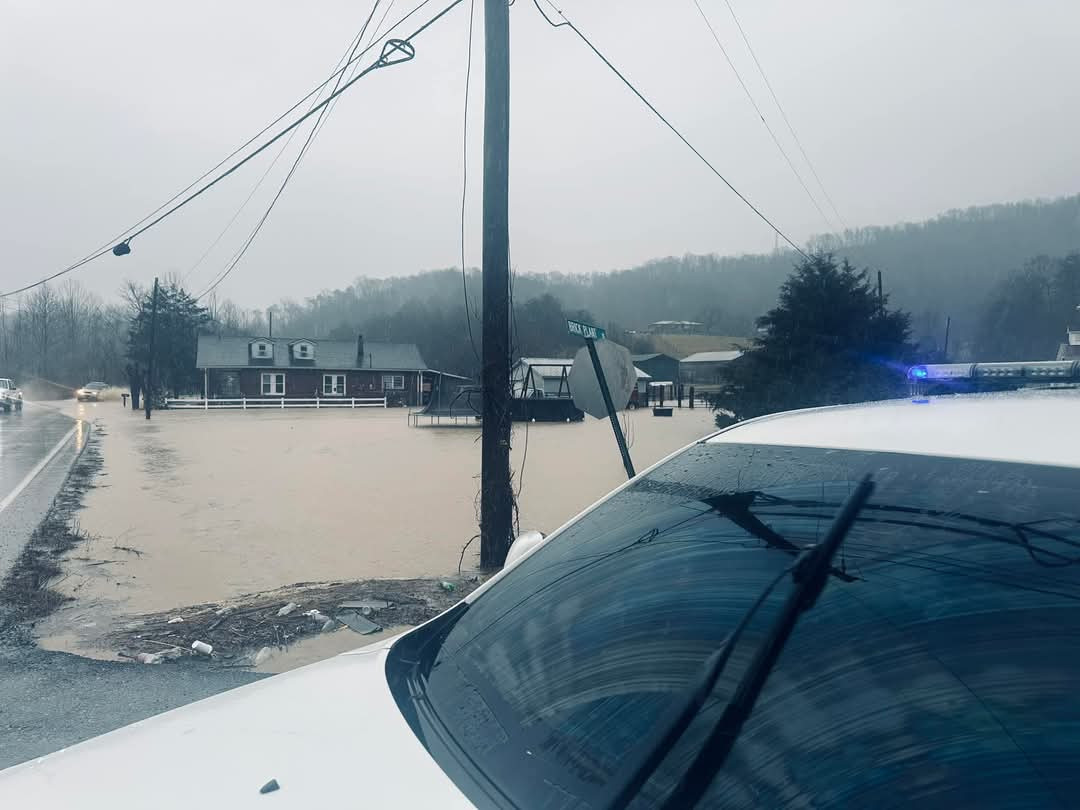
Around my area this afternoon. If we get poured on again tonight, some really dangerous situations may develop in the dark.
-
4
-
 1
1
-
 1
1
-
2
-
-
The ICON was similar to the Euro.
-
5
-
-
Each model is basically a little colder and a little heavier on the snow output than the runs from 00z.
-
5
-
Winter 24/25 Observations
in Tennessee Valley
Posted
Snow has been moderate at times this evening. The roads are even getting covered as the temps are in the 20s.