

John1122
-
Posts
9,688 -
Joined
-
Last visited
Content Type
Profiles
Blogs
Forums
American Weather
Media Demo
Store
Gallery
Posts posted by John1122
-
-
19.6 degrees, snow still flying. We'll talk about this week for a long time.
10.25 inches of snow, snow in the air for probably close to 40 hours. .10 freezing rain with temps around 29/30. Low of -8. Below freezing for a week+.
-
 3
3
-
 3
3
-
 1
1
-
-
35 minutes ago, Uncle Nasty said:
I'm happy for everyone. It was amazing the difference of a few miles in the Chattanooga area. I'm in Ooltewah where we might have received 1/4" of snow. 6 miles to our north started the accumulating snowfall. 2" and then higher totals of 6-10. All the snow was north and east of us 6 miles. Maybe 8 miles away in Harrison near the lake 4" was widespread. We received the warm nose shaft here. Oh so close.
Sent from my SM-S916U using Tapatalk
My brother in Hixson not far from the high school, got about 3 to 4 inches. Sorry it missed you.
-
2
-
-
Big fluffy flakes flying out there. Snow flow here seems to always pick up as we get towards dark. Some of the biggest flakes of the day flying out there right now.
-
2
-
-
It's a beautiful day with 2 fresh inches of snow. A bit windy though.
-
7
-
-
The Plateau NW flow radar blind spot couldn't be more obvious than it is today. The snow looks like it just magically regenerates at the edge of it today. It's a perfect wind direction for Knox to get in on it.
-
5
-
-
This week is basically straight out of the 1970s and early to mid 80s. Back then we'd have a period like this every winter. Sometimes two or three.
-
9
-
-
Steady snow showers still rolling this afternoon in the NW flow. We may not see flakes fall for a good long time after today, so I'm enjoying it.22
-
4
-
-
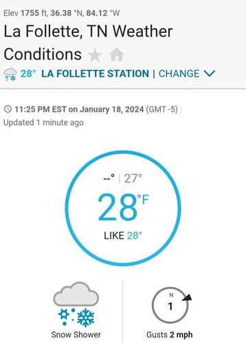
Picked up an inch overnight into today. Have had some aggressive snow shower activitity. Arctic air is flowing in now. Gusty winds and temps are now in the 20s after being 31 an hour ago.
-
1
-
-
Back to a pretty good snow shower right now. It's freezing drizzle, snow, freezing drizzle.
-
1
-
-
With the deeper returns exiting, I'm back to heavy freezing drizzle/mist with a temp in the upper 20s. There's 6 inches of snow on the ground, a crust of ice, a 1/4th inch of snow on top of that ice and now a glaze of ice going over that. With some sleet in the layer too.
-
2
-
-
1 minute ago, Save the itchy algae! said:
It looks like this is pretty much it then the storm is done, anyone else seeing something different?
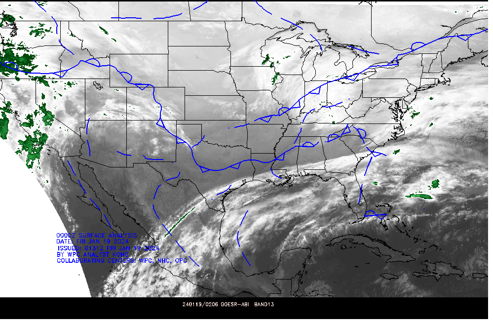
.Upslope and extreme cold are the big parts of this one still to come. I expect there should be wide spread snow showers around tomorrow just from the Arctic air squeezing out every bit of moisture possible. It's rare to have a front that sends temps falling into the 10s during daylight hours that doesn't have snow showers. So I'd expect a good dusting to maybe 1/2 inch even in non-flow areas tomorrow.
-
4
-
1
-
-
Temp is falling a bit more and I've gotten about 1/4th inch of snow on top of about .10 ice.
-
2
-
-
54 minutes ago, Jesse from KY said:
In Northern Bell County, we've had some light snow the last while. It's tapered off now, though.
Could we see another surge before the night is over? Current temp: 32F
I would think you'll get some upslope from this. Maybe an inch or two but don't hold me to that.
-
The whole county is basically emergency travel only now.
-
1
-
-
4 minutes ago, jaxjagman said:
Still think you can get some more snow.The inverted trough that helped with the warm nose,the cold front is stationary,we could get a few flakes here maybe but seems to me the higher elevations could get something,wont be much but it seems to me you could squeeze maybe a tenth or so before it done.That map is a hour old
I hope so. I believe there's issues with getting moisture to the dgz because we shift back to drizzle when it's not coming down hard.
-
3
-
-
Approaching mm134. At least it's not freezing rain any more. They can't clear the interstate so tdot can't salt.

-
3
-
-
10 minutes ago, jaxjagman said:
you should stay snow now
Hopefully, but it's about gone until any NW flow might happen. It was odd that 30 degrees today felt warm.
-
1
-
-
Now have moderate snow with a few sleet pellets.
-
2
-
-
3 minutes ago, PowellVolz said:
Can’t find Campbell Co on my free scanner for some reason. Are you listening to public safety of highway patrol?
.It's 453.1875 on a scanner.
-
1
-
-
Campbell County e911, plus LaFollette.
-
1
-
-
5 minutes ago, PowellVolz said:
Are you listening to Anderson Co or Campbell Co scanner?
.Campbell County. There was just another wreck southbound. They are going to try and shut it down at the KY border it sounds like.
-
It's bad. There probably needs to be some kind of notification that's a more severe warning than a winter weather advisory in such unique circumstances. The roads were primed for this to become a disaster area with freezing rain because of the extreme cold.
A police officer also wrecked a few minutes ago trying to get to the interstate.
-
2
-
-
I've now switched to sleet and snow.
-
2
-
-
6 minutes ago, PowellVolz said:
Scanner? How are you getting your info?
.Scanner.
-
1
-
Cold Shot: Part Duex - January 18-20th Arctic Blast and Freezing Rain/Snow Event
in Tennessee Valley
Posted
My cousin just sent me this picture of I-75 right now. It's just to my NW in the area of no radar returns.