

John1122
-
Posts
9,688 -
Joined
-
Last visited
Content Type
Profiles
Blogs
Forums
American Weather
Media Demo
Store
Gallery
Posts posted by John1122
-
-
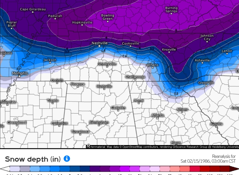
The 1986 event. This is snow depth the next day.
-
 3
3
-
-
2 hours ago, PowellVolz said:
I remember the Valentines snow in 86, I was in middle school. Help me out here… was that sorta of a surprise for people north of 40 in Knox Co? Maybe I’m getting that part confused but I remember doing Valentines Day stuff in school and it starts snowing chicken feathers. My dad had the only 4x4 in my subdivision and he made several trips to and from picking up kids and getting them home. (How I would love to go back to a time when no one worried about a kid getting kidnapped or abused if you sent them home with a parent of another student ). So in my middle school years I remember two major snow events. The V Day storm and one that happened maybe in April? One of these storms was a surprise because we all got stuck at school. I remember watching the weather later that night and they showed South Knoxville with only rain while Powell/Halls had 6-10”.
.The snowline in 1986 was south of 40 in East Tennessee. It snowed 5-6 inches in Oak Ridge, Lenoir City, and at McGhee-Tys. By Athens and Chattanooga there was only a trace though. The highs south of 40 were around 35, along 40 around 32, and along the Kentucky/VA border, upper 20s. Strangely for the set up, it only snowed 2 inches in Crossville with a high of 33 on .70 precip. It snowed 6-8 inches in Fentress County just north of Crossville.
I don't remember it being a surprise though. Just that back them you went to school and if it started snowing, you went home.
-
3
-
-
1 hour ago, Carvers Gap said:
Day 8-14 analogs:
19800207
19530209
19650228
19680207
20040209
19770211
19780216
19700209
19860206
20060207
2-07-80 8 inches of snow from 2-6 to 2-8. But it was the middle of a long/snowy stretch with quite a few below 0 lows and 17 straight days with snow on the ground here.
2-28-65, mild with highs in the 60s.
2-09-53 mild. Highs in the 50s
2-07-68 40s but went into the deep freeze the next day. Dry deep freeze.
2-09-04 slightlybn, 40s./20s
2-11-77 climbed out of the deep freeze to near 60.
2-16-78 chilly, 30s/20s, 2 inches of snow
2-09-70 a few bn days in a row. But 3 or 4 degrees bn
2-06-86 near 70 degree highs. We did get a huge Valentines day snow storm with 10 inches in 86.
2-07-06 a couple days around -5bn but dry.
-
2
-
 1
1
-
-
The EPO is going negative and the PNA positive around mid-month. That happened in the 2015 El Nino and we got harsh winter the last 10 days of February and the first week of March capped off winter with a West Tennessee blizzard.
-
7
-
1
-
-
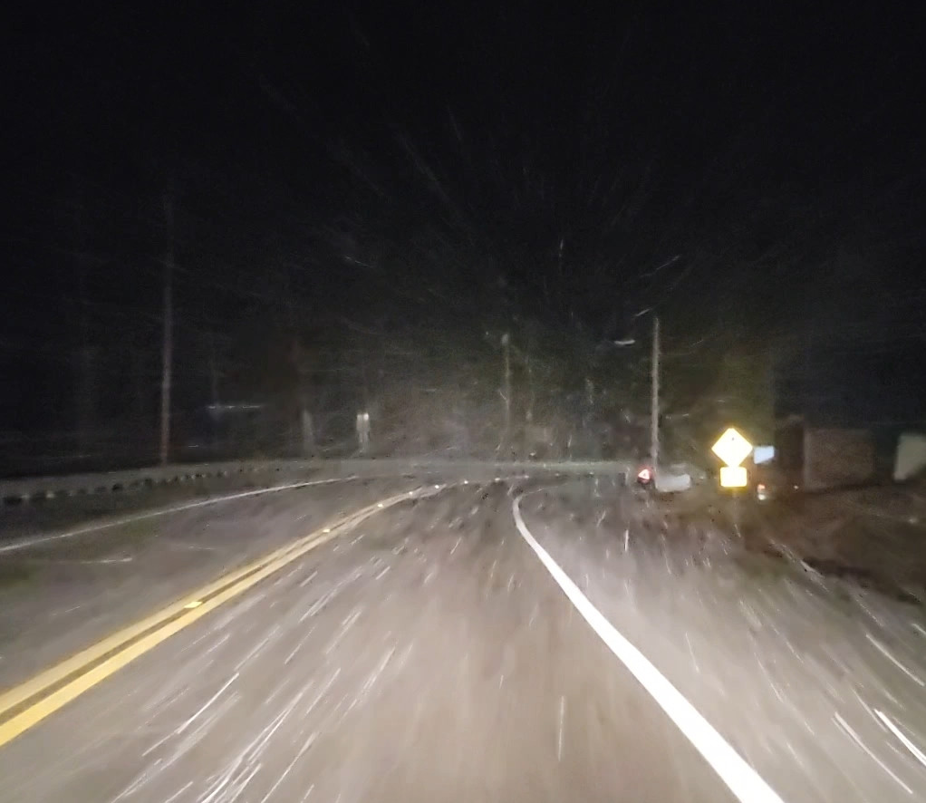
On the drive home a little while ago.
-
5
-
1
-
-
Thunder in mountains has proven correct again with a snow showery day.
-
4
-
-
42 minutes ago, dwagner88 said:
MRX messed up their event report for this. Officially KCHA got 1.7". MRX's report states that this is the most January snowfall for KCHA since 1996. They seem to have forgotten about the January 2011 snowstorm that brought nearly 8" to KCHA overnight. 1.7" being the largest event in 28 years is really sad. Even for here.
Chattanooga also got 5 inches on January 29th-30th 2010.
-
2
-
-
Had several rumbles of thunder and my current weather forecast says up to an inch of snow possible tomorrow night. We need more winter thunder.
-
3
-
-
I just saw some verification scores, and what should be much to it's embarrassment, the GFS at 500 has been scoring worse than even the JMA.
-
2
-
-
It has been in the mid 60s to near 70 across the entire area 3-4 days before that first Miller A on Valentines.
-
3
-
-
Look at the Euro and look at the Miller A tracks from Feb 1960. The Euro is slightly further north at the start.
Here are some snowfall totals for Feb 13-14th 1960.
Memphis 1.1 inches
Jackson Tn 3.5 inches
Nashville 6 inches.
Murfreesboro 8 inches
Chattanooga 9.5 inches
Cookeville 10 inches
Tri-Cities 11 inches
Middlesboro Ky 14 inches
Williamsburg Ky 15 inches
Crossville 15 inches
MBY 16.5 inches
Norris 16.5 inches
Tazewell 17 inches
Monteagle 17.5 inches
Knoxville 18.3 inches
The 18th-19th event that followed it was a widespread 4-8 inch event.
-
2
-
1
-
-
Eric Webb noted that the storm as modeled was the same setup as a massive March 1st 1927 event. That was a monster for East Tennessee. 8-12+ inches fell.
-
5
-
-
It gives us a little bit of backside snow. But that was a miller A dream track.
-
2
-
-
The Euro just had a great pass in what would likely be a nice winter storm here. I refuse to believe that a low dropping from 997 to 991 as it skirts the northern gulf coast from Louisiana over the panhandle of Florida would be precip free here.
-
3
-
-
28 minutes ago, Stovepipe said:
I had to head up to Jacksboro today and man, I nearly broke an axel. I've never seen the interstate in such bad shape. I was also fortunate enough to get stuck at the Caryville on-ramp while they shut I-75 down to patch some holes. Also, it's amazing how much fog builds over there around Cove Lake. Campbell county really is another world lol.
The lake was frozen over until yesterday and probably still was in parts. It generates a lot of fog when it's so cold and the air over top is so mild. It's foggy as heck here still right now, though most of the snow is gone, it's still holding on in a few places and along sides of the road in my area.
That section around 134 was the area that had 11 wrecks in about 15 minutes when the freezing rain hit.
75 from the Campbell County border to the Kentucky border is an absolute menace.
-
2
-
-
Today I observed rain, thunder and 9 cars on I-75 with flats from potholes.
-
1
-
-
Just drove through a thunderstorm in Clinton.
-
3
-
-
It just thundered loud here.
-
4
-
-
I've got around an inch left now. It's so foggy here you can't see a hundred feet with the warmer air over the remaining snow. It's went up to 46 now, after holding in the lower 40s all day. I expect the snow to be gone by morning mostly. When that fog arrives, I've always called it snow eating fog.
-
2
-
-
It's 43 degrees imby with 3 inches of snow still on the ground. It's 56 about 6 miles away where the snow melted off.
-
3
-
-
14 minutes ago, TellicoWx said:
22° temp spread across the county..sitting at 70.1 currently
That's insane!
-
2
-
-
Probably time for a February thread. Most anything in the median to long range is in February now.
-
1
-
-
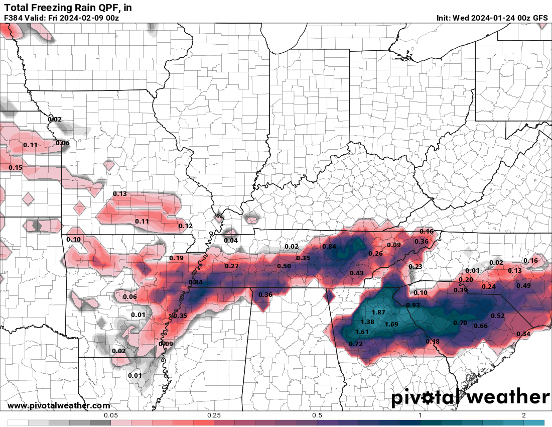
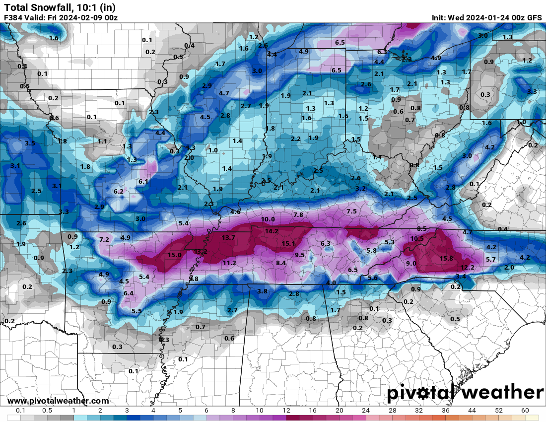
The GFS kinda brought back winter in early February....this is a result of a 3 or 4 day winter storm that just slams us. Lots of sleet too. This would be a repeat of Feb 1996.
-
6
-
 2
2
-
-
19 minutes ago, Shocker0 said:
Here is a screenshot from the 1996 snow taken from one of my girlfriends home movies. This is in Oakdale, TN (Morgan County).
Looks super deep to me. I should have a higher res version tomorrow as this was a quick screengrab while converting it to digital format.

It snowed truck beds full here. It was the first winter storm that I did a snow board and cleaned it off for measurements every three hours.
-
2
-

February 2024 mid/ long range
in Tennessee Valley
Posted
It happened a few years ago. I think the cold went to Asia. This is the map of all SSWs and where the cold is most likely to arrive. The Eastern U.S. is actually a very favorable destination on average.