

John1122
-
Posts
9,688 -
Joined
-
Last visited
Content Type
Profiles
Blogs
Forums
American Weather
Media Demo
Store
Gallery
Posts posted by John1122
-
-
There's now 8 wrecks at mm 132 to 133. 75 is shut down. Officers say they can barely stand up at the scene.
-
 1
1
-
 2
2
-
-
1 minute ago, PowellVolz said:
That is terrible.
.From what I can tell there's now 5 wrecks, 4 of them semis, on 75 in cc.
-
3
-
1
-
-
75N is a doomsday scenario. 3 wrecks involving semi trucks at mm133 including one overturned. Officers at the scene said it was so slick they couldn't get to one of them.
-
4
-
-
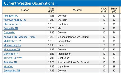
Strange OBS from Tys and Tri.
-
3
-
-
Back to sleet. Sleet when it's heavier, drizzle/freezing rain when it lightens up.
-
2
-
-
Now freezing rain here.
-
2
-
-
Still switching between snow and sleet. No freezing rain so far.
-
6
-
-
Temp has fallen to 29 with precip. I assume wetbulbing is happening.
-
2
-
-
4 minutes ago, Daniel Boone said:
I assume the further ENE one travels from there the slower snow to sleet changeover or mixing . I expect mainly Snow and sleet here, all Snow Wise on NE.
I'm hoping for upslope tomorrow as the main snow producer. The 3k NAM is spitting out about 2 inches of that here with 5+ over Cross Mountain. The freezing rain/sleet part looks qpf starved with less than .10 per MRX. MRX did note the warm nose won't reach SWVa at all.
-
1
-
-
Switched over to sleet with an occasional flake. Temp is 31.
-
4
-
-
Snow just started here.
-
5
-
-
Just now, Carvers Gap said:
Interesting. Yeah, this most recent winter storm occurred as we moved from 3 into 4. 3 is also a decent phase for winter storms. I need to get my hands on an MJO tendency plot for El Nino winters.
His chart was for North Carolina and while we can score in different ways and often do, most of the time we're all cold at the same time and the storm track that lends itself to NC snow events most is miller A storms. It was I believe an 8 percent chance in 7/8, 5 in 1, 3 in 2 during El Nino. It would take a lot of research to do it here, if had a way to get historical MJO phases I'd try to see how we stacked up.
C.O.D is king. It's a 12 percent probability in Nino years.
In nino Feb 2015 we were 8 to 7 to C.O.D when big winter hit in the second half of Feb.
-
3
-
-
I've made it to 27 degrees. I noticed the Crossville airport was at 33 but has fallen to 30. Dewpoints are low, in the 10s, so some wetbulbing will occur.
-
5
-
-
1 minute ago, Carvers Gap said:
Interesting. Yeah, I have never hated 7...but the CPC temp maps imply warmth here. I have always associated it with cold during later winter as well.
He actually made the statement that the MJO heading for 7/8 in February was one of the reasons for hope in the long range. It appears that 2 may be the worst phase for winter storms in El Nino years.
-
3
-
-
It was in an El Nino, phase 7/8 were the most likely to produce snow in NC of any phase but the c.o.d was best.
-
2
-
-
I believe Eric Webb found that southeast snow events in February were more frequent in Phase 7 of the MJO than some of the more traditionally wintery phases. That would imply that it was cold here during Phase 7 in February.
-
3
-
-
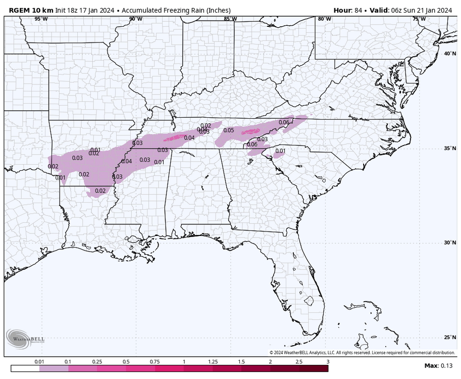
If this happens as a drizzle/ight rain scenario it's the worst way to get freezing rain for travel. If it rains hard it builds up on raised surfaces but the way roads are designed to shed water, the water starts running and it's harder to freeze. But light rain that slowly builds, that's just the worst.
-
4
-
-
Man, the HRRR spits out ice storm warning criteria ice here. Exactly what I don't need with temps near 0 returning.
-
4
-
-
2 hours ago, GaWx said:
I assume you realize that you turned out to have the right idea with Knoxville's actual low being 0 and Tri's actual low being +3 vs yesterday's 12Z GFS progging -14/-13. I counted at least the four prior runs as well as the 18Z having something similar. However, interestingly in case you didn't see it, the subsequent 3 runs starting with the 0Z suddenly warmed ~10 and thus were much closer to reality. We agree that it takes near perfect radiational conditions for the GFS to be close in these situations when it's extremely cold. That may have happened in some cities of TN from what I've read. If anyone could be more specific about these cities and post the 1/16 12Z GFS prog compared to what verified, please let us know. But most of the time, extreme GFS runs like that 12Z run you noted for Knoxville and Tri seem to end up quite a bit too cold. I first learned about this cold bias over fresh snowcover from a pro met whom I know.
I see that the -14 progged Knoxville low was a whopping 44 BN! So, the actual low of 0 was a "mere" 30 BN.
The GFS from 00z 1-16-24 had me at -8 and I ended up at -8. It had Newcomb, west of me at -6 and they ended up at -7. It had Oneida at -7 and they ended up at -9. It had Tazewell at -14 and they ended up at -12. Our posters in the area also seemed to have recorded -8 to -10. Unfortunately TYS is not actually in Knoxville or Knox County, and it's a notorious heat island, I believe they didn't get quite as much snow as areas very close by to the N and NW.
-
1
-
 1
1
-
-
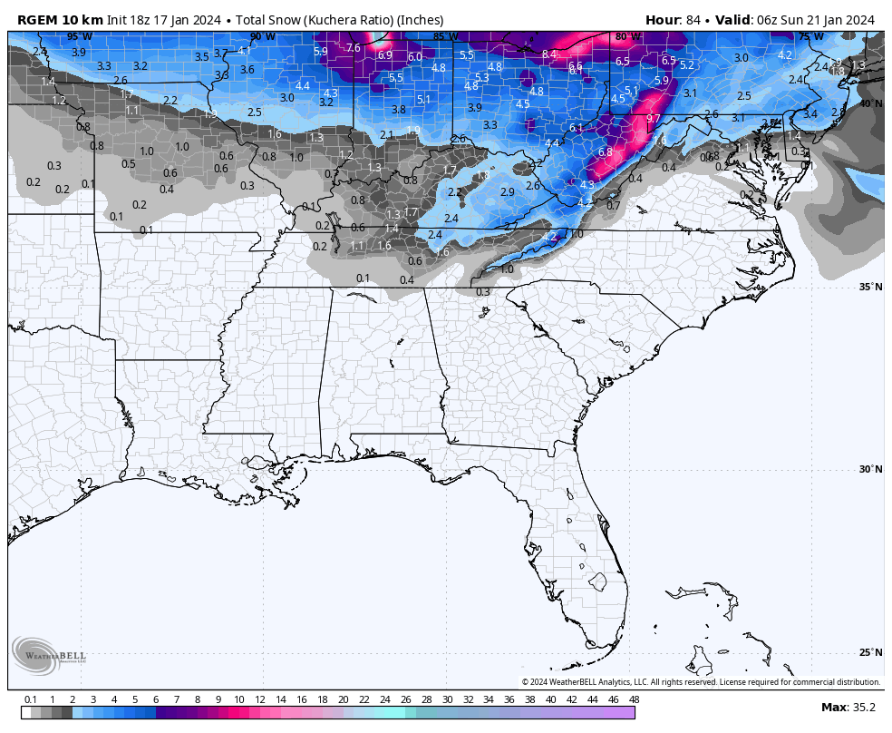
The Canadian crept south with the snow. The 3 inch line crept into NE Campbell County that run. The one inch line is down across Knox and Davidson in Middle Tn. Almost looks like the snow footprint models were putting out a few days ago.
-
3
-
-
I've just blew through my predicted low. My zone forecast says 15, my point forecast says 13. It's down to 9 degrees already.
-
5
-
-
42 minutes ago, Silas Lang said:
RGEM is persistent. Also been the best with temps, for me at least. It shows a chilly upper 20s in the early morning hours with rain for the central valley. Temp profiles seem to highlight snowpack fairly well.

The RGEM is good with northern stream stuff. Hope that's the case here.
-
1
-
-
33 minutes ago, Carvers Gap said:
This winter reminds me a lot of 95-96. It was showing up as an analog a few weeks back. There were a couple of storms maybe 3 weeks apart(I can't remember exactly). This may have that. I agree w/ Boone that the Feb pattern could have a big dog or two as we rarely see teleconnections line-up that well. I just wish the pattern hadn't been kicked back a week.
2014 we got below 0 cold in early January then a two week warm up and got frigid again in late January. So it was a double cold shot El Nino year.
-
2
-
-
I've made it to 22 but not sure I'll get much higher. The sun sets here pretty soon.
-
2
-
Cold Shot: Part Duex - January 18-20th Arctic Blast and Freezing Rain/Snow Event
in Tennessee Valley
Posted
11 wrecks now.