

John1122
-
Posts
9,702 -
Joined
-
Last visited
Content Type
Profiles
Blogs
Forums
American Weather
Media Demo
Store
Gallery
Posts posted by John1122
-
-
Just now, 1234snow said:
And this model will be replacing the NAM, HRRR, and the RAP?Yes, according to NOAA.
QuoteWithin the NOAA model unification effort, the RRFS represents the evolution of the NAM, RAP, HRRR, and HREF systems to a new unified deterministic and ensemble storm-scale system. This new system is targeted for initial operational implementation in late 2024 as a planned replacement for the NAMnest, HRRR, HiResWindows, and HREF.
-
 1
1
-
 1
1
-
-
3 minutes ago, Holston_River_Rambler said:
Is that the RRFS?
Yes, it looks a lot like the 3k NAM. Probably because it is essentially the 3k NAM and the HRRR wrapped in one. It runs as a hi-res deterministic model for the first, I think, 36 hours and finishes to 60 as an ensemble run.
-
1
-
-
1 minute ago, Greyhound said:

.It's the NAM upgrade coming to full time use later this year. Maybe it has the same biases the NAM does.
-
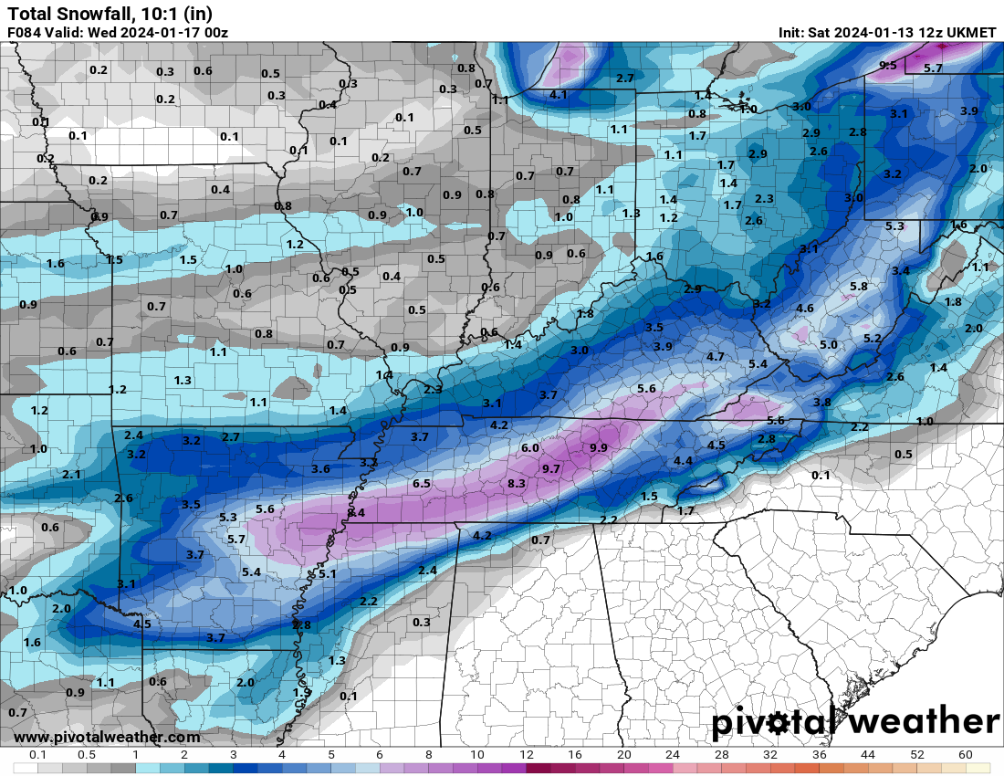
UKIE. 10:1 may be right here because it gets up into the lower 30s in the East. Probably a 75 mile shift SE.
-
3
-
-
The UKIE took a jump Southeast and is more in-line with the RGEM. The NAM family seems to be in the NW camp by itself now.
-
4
-
-
17 minutes ago, Holston_River_Rambler said:
Close to a big dog again on the 12z GFS for the late week system
Looks like it was more than close!
-
4
-
-
Well maybe it won't get better. It's warm nosing like crazy and has rain in Crossville and mid-40s up the Eastern areas.
-
The new NAM replacement is out to 53hrs and it's a little south of the NAM but not by a ton. Its snow shield is almost right along 40 in East Tennessee and west of I-81. But it will likely be getting better for the East towards 60. Memphis gets 4 inches of snow and changes over to sleet and freezing rain on it. What a nightmare that would be, if zr gets involved.
-
2
-
-
RAP at the end of it's run.


-
1
-
2
-
-
12z FV3 still snowing heavily Plateau and east at 60.

-
2
-
-
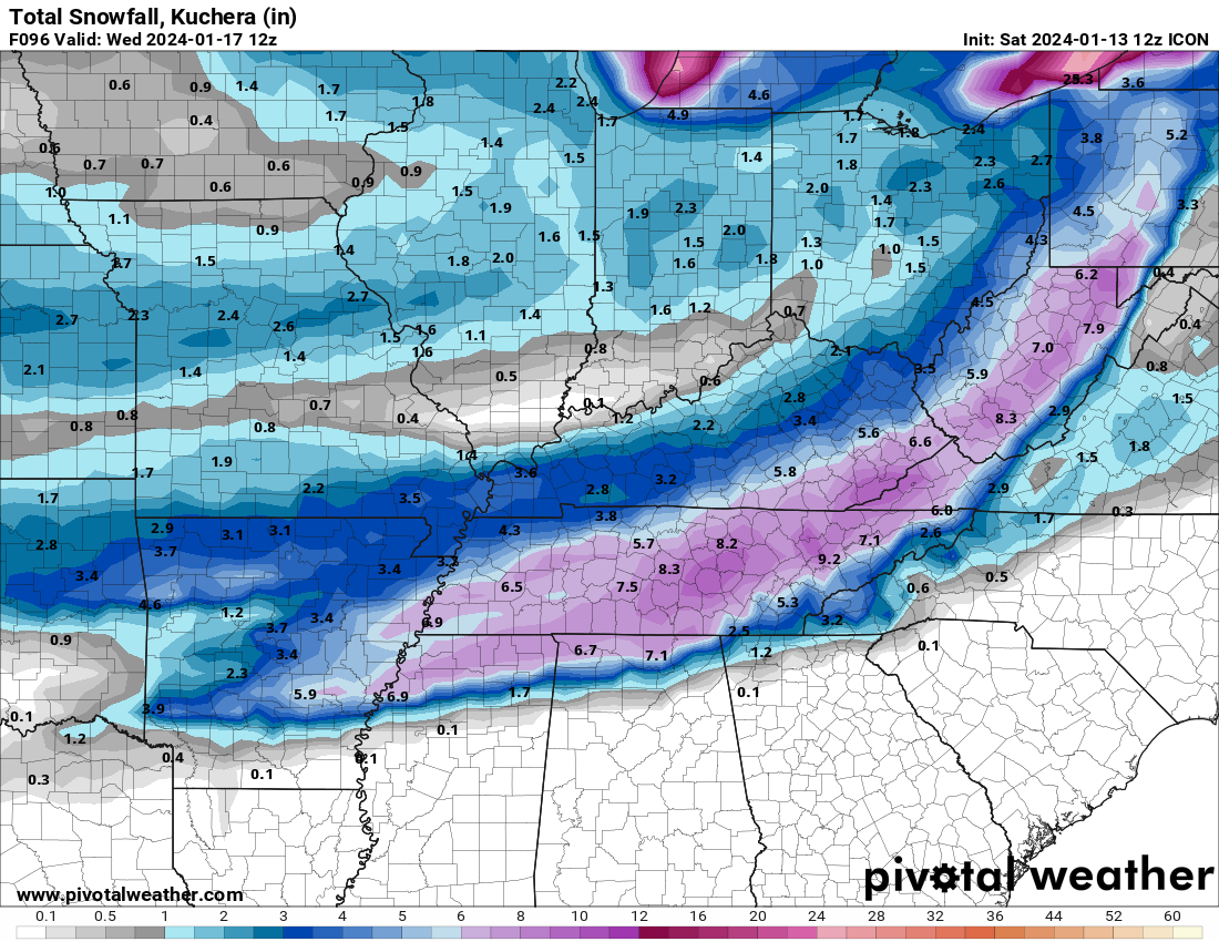
ICON keeps things pretty steady, it may be wrong but it's remarkably consistent.
-
2
-
2
-
-
GFS is furthest south because it's flatter, weaker and fastest out it looks like.
-
1
-
-
GFS was basically a repeat of 0z. Its the furthest south right now with the NAM being the furthest North. Usually they are in closer agreement like the UKIE and Euro, but those two are also at odds.
-
1
-
-
4 minutes ago, Stovepipe said:
From an east Tennessean perspective it doesn't feel good not having the NAM on board, but it is what it is.

It's on a very wonky island right now.
-
1
-
-
The ICON went back into super beast mode,

-
2
-
-
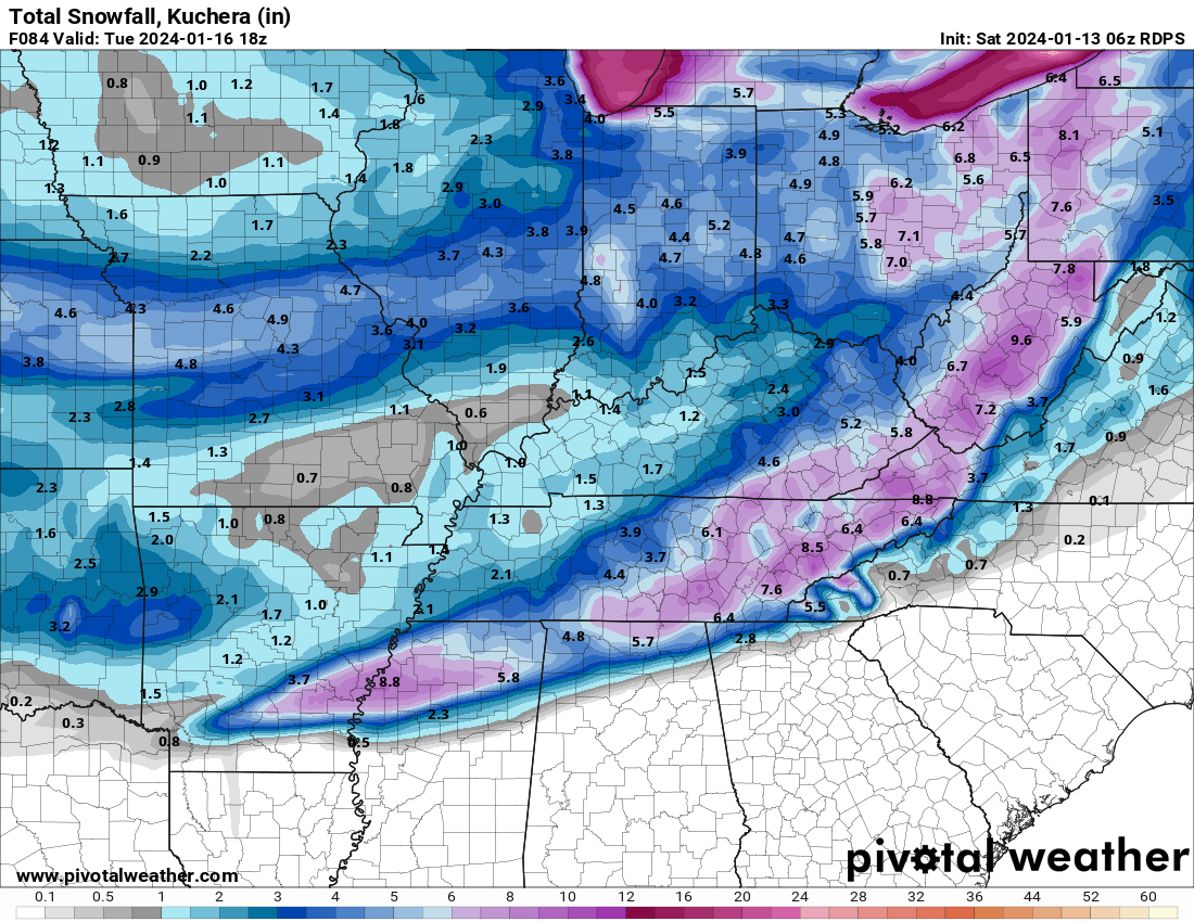
RGEM is a boom again though not as much around Memphis.\
-
2
-
-
The RGEM and ICON look around what all other modeling besides the NAM/UKIE are showing. Still not to the end yet though.
-
Looks like all of the Eastern valley except for Bradley and Polk are in the Winter Storm Watch. We may come close to a state wide watch.
-
I'm honest to goodness not even sure what to make of that NAM run. Sends a massive dry warm nose north while a monster snow/sleet and freezing rain band sits over the same area for a good 12 hours then pops a low off the South Carolina coast, but the precip band still sits in the same place for a few more hours.
-
The NAM has went crazy, amped up and raining.
-
The 06z NAM is having the dewpoint issue again. It has my DP at 0 at hour 45 and just above the surface at around 900mb it has the dewpoint at -30 degrees.
-
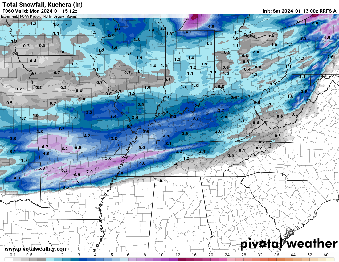
The new Hi-Res NOAA model that is in it's early stages. It goes to 18hrs most runs but goes to 60 some runs. This will replace the NAM/RAP/HRRR.
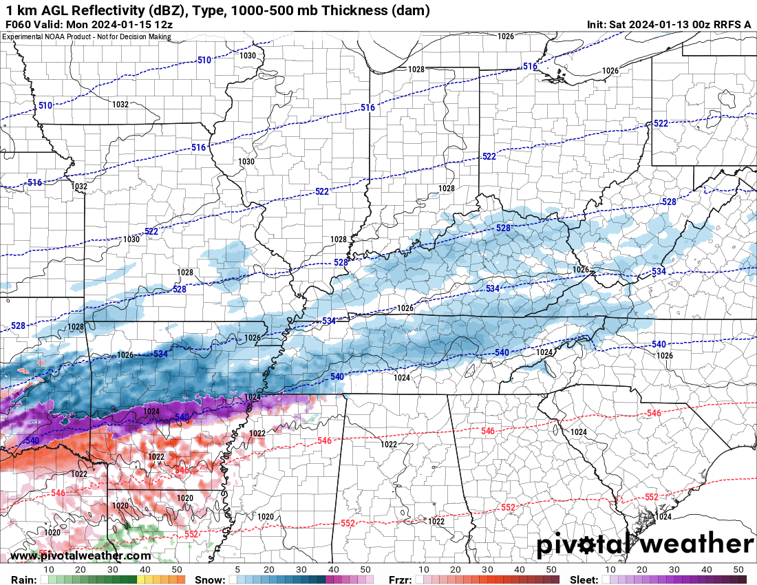
Where it had gotten to through 60.
-
1
-
-
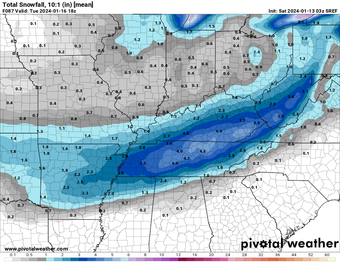
03z SREF 10:1 mean. These would be higher ratio'd.
-
1
-
-
The 03Z RAP at 51 which is the equivalent of the 54 hour panels on the 00z suite.

-
1
-
1
-
January 15th-17th 2024 Arctic Blast/Snow Event
in Tennessee Valley
Posted
I believe in the case of the RAP there, it's still very early in the storm evolution and it should still have 12 hours or so to go with hopefully a better cold press. But after looking at some of the NAM family members, maybe not.