

John1122
-
Posts
9,702 -
Joined
-
Last visited
Content Type
Profiles
Blogs
Forums
American Weather
Media Demo
Store
Gallery
Posts posted by John1122
-
-
Chattanooga, Knoxville and even Northern Alabama getting hit good, Northern Miss made out like a bandit.
-
 1
1
-
-
Euro is probably going to look like the GFS.
-
 1
1
-
-
The Euro is going to be south it appears. Hopefully not back its near nothing runs from yesterday.
-
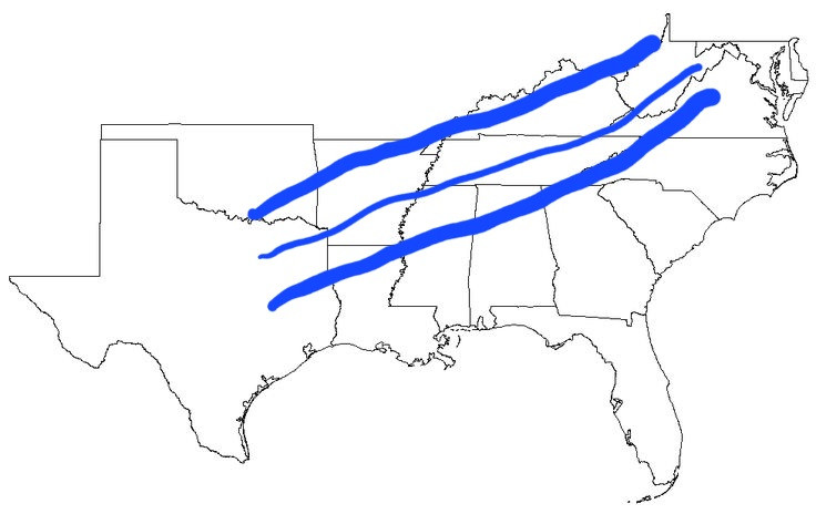
I'm not as good as Lil Flash but this seems to be the window.
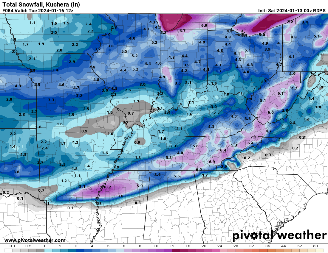
The UKIE/NAM are around the middle line to the NW line. The RGEM/ICON are around the middle line with some spillover. The GGEM and GFS are around the middle line and tilted toward the southern line. That's our window and I feel like it's set. Some but probably not all in the window will see 3+ inches and some will be on the outside looking in ala the Kermit picture from a few days ago.
-
2
-
2
-
-
Right now the NAM/UKIE are West/NW edge of guidance. The RGEM and ICON are in the middle. The GFS and Canadian are the southeast envelope.
-
The UKIE remains NW, even more than the NAM. 3+ inch line from Middleboro down to Campbell and far NW Morgan and Cumberland etc. Falls off fast east and southeast of that line. Monster run through the west and mid-state.
-
2 minutes ago, Stovepipe said:
The Dandridge Dollop?
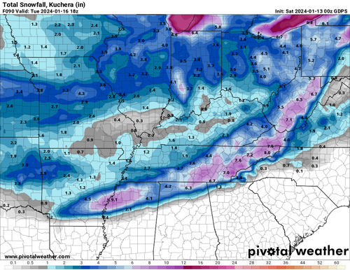
Sort of but bigger. About the southern half of Jefferson and a good part of Sevier co. The mean is a bit more East Tn centric than I'd noticed. The 3.5+ inch mean is basically Scott down to Cumberland and points east. Surprised that no one out west made it to 3.5 inches.
These are all 10:1 btw.
-
1
-
-
There was a set up like this in the early 2000s, I can't remember the year but I was probably 10 miles north of the snow band and it just went on all day with light snow where I got about an inch in 10 hours and just south of me got 4 to 6 inches. It was painful, 24 hours out I was in the bullseye, and was under a WSW for 4-8 inches.
-
1
-
 1
1
-
-
The GEFS mean was similar to the OP but lesser amounts towards Chattanooga and more towards the Kentucky border north of Nashville. One member just absolutely crushed the Eastern Valley near the mountains and it skewed the mean a little and there's a 5 inch bullseye east of Knoxville.
-
2 minutes ago, Stovepipe said:
Remind me, when is the Super Bowl again?
It's a few weeks down the road!
-
Uncle Nasty's plea was heard for this run.
-
4
-
 3
3
-
-
Canadian is going well for Chattanooga too.
-
2 minutes ago, tnweathernut said:
Pretty normal oscillations happening, IMO. In the overall scheme of things we see models waffling back and forth about 75-100 miles. Probably not unreasonable. We can all hope the overrunning is a bit more robust when we get to game time.
Yep, there's going to be a snow band that's probably 150-200 miles north to south but because of the angle, someone likely gets left out. I am surprised the window actually opened wider vs 12z and 18z when it was narrowing.
-
Looks like the GFS is going to get the south siders this run.
-
4 minutes ago, Hurricaneguy said:
I'm in Greeneville. I do not like seeing the cutoff right on our county. When it's been nearly two years since a decent snow that drives you crazy lol
I completely understand that. One year in the 2000s, back around the time Stove was referencing earlier, it literally came a 4+ in snow in every single county in the area except here in my area. It was around 4 events that I just missed to the West, East, North and South. There was about a 10 mile circle with almost nothing and I was in it.
-
2
-
2
-
-
Just now, Hurricaneguy said:
Icon and Nam bust for East TN. Man we are so close to this event. It's frustrating.
I'd actually call the ICON pretty kind to probably 80 percent of East Tennessee.
-
5
-
-
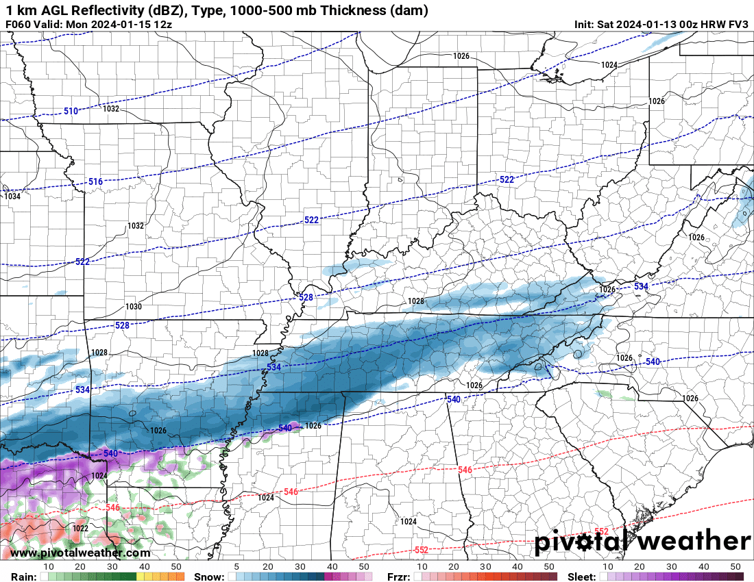
This is the highest res of the NAM nest at hour 60. Actually looks like the RGEM more so than the 12k NAM.
-
1
-
-
1 minute ago, tnweathernut said:
It shouldn’t be, but I have learned to never discount it completely.
Knowing your microclimate is basically the be all/end all for forecasting here.
-
3 minutes ago, tnweathernut said:
Agree. I was waiting for the heavier snow bands on the icon to pivot through NE TN. For some reason they just dissipate. Not likely, but I suppose it could have been downslope aided.
I honestly would've thought downslope wouldn't be a thing with this particular set up.
-
3
-
-
-
2 minutes ago, tnweathernut said:
ICON spreading the overrunning love here at 0z
It's rocking. So far the 12k NAM was the outlier at 18z and looks like it's 2 to 1 against it at 00z.
The positive, someone is getting a big snow. The Memphis to Nashville are just about locked in across all modeling. The Plateau is close to it as well. NE Tn, SETn and NW Tn SWVa seem to get less on various models.
-
1
-
-
ICON looks like it will also maintain a good hit for basically the whole forum.
-
2
-
1
-
-
-
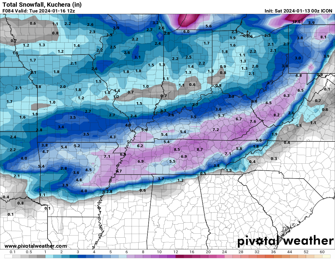
The RGEM is actually south of its 18z and less QPF.
-
2
-
January 15th-17th 2024 Arctic Blast/Snow Event
in Tennessee Valley
Posted
The Euro was a little north of the GFS that run. And it brought much more QPF than the prior two runs.