

weatherwiz
-
Posts
71,023 -
Joined
-
Last visited
Content Type
Profiles
Blogs
Forums
American Weather
Media Demo
Store
Gallery
Posts posted by weatherwiz
-
-
Does look like there could be a chance for some elevated convection tomorrow night and if we can get enough breaks of sun Thursday maybe a few decent localized storms.
-
 1
1
-
-
Actually I wonder if there is some room late tomorrow evening for some activity?
EDIT: Oops..was looking at the wrong day.
-
14 minutes ago, OceanStWx said:
Well modeling definitely coming into agreement on the release of an EML plume for the coming weekend, but unfortunately for severe weenies heights are also rising through the weekend. So Kevin gets his HHH. Maybe the best shot at storms comes as that air mass tries to move into the area.
I was checking to see if we would have a shot at some fun with the warm front but I wasn't overly impressed. Sometimes when we get those secondary warm fronts to push through (the ones that really bring in the HHH) they can be active but it's a bit rare. I remember one event in the late 90's or so where we had supercells in CT like early afternoon in association with the warm front. I wish I remembered the date but it was sometime in late June or July b/c I remember being out of school. I don't remember the day of the week either :/
-
Quite a bit of MUCape later on
-
Funky Murphy’s was great and fairly central located.
-
NAM interesting across south coast as well for Saturday night. I know that's been discussed for a few days.
-
1
-
-
Grauple/small hail showers Monday?
-
1 minute ago, Damage In Tolland said:
And such?
?
-
17 hours ago, OceanStWx said:
Half serious anyway. Right now we only differentiate between hardwood and softwood (and some mets probably don't know the difference) and not by species. Hell if I know if ash or elm breaks first in strong wind.
You know what's interesting...after seeing the damage across western CT after the event I started to notice that there seemed to be a striking similarity with regards to the type of trees that were knocked down and which weren't. I don't know anything about tree species and such but my friend from NH does. I wish when he was done for a few weeks I had thought about this b/c I could have mentioned it to him and he could have looked at the trees and such. But it was weird b/c you would have an area of damage and the trees that were down seemed to be a similar species.
-
stuff west of CT starting to come up
-
Good lord...glad you're alright
-
8 minutes ago, CT Rain said:
They sure do.
It's really becoming quite intriguing, especially when you take into account the consistency hi-res models have on activity moving into the state...this coincides with combination of best shear/instability (well maybe weakening instability but still sufficient).
4 minutes ago, OceanStWx said:With moist low levels and steep low level lapse rates, you do get buoyancy in those lower levels for stretching/mix down potential. So while mid level lapse rates would be nice, we don't need 40+ kft towers for strong storms today.
Yeah good point...these low-level lapse rates are quite steep so won't take much for strong wind gusts. Even some Td's of 71-73 not far SW...that alone will help compensate a bit for crappy mid-level lapse rates.
-
RAP/HRRR continue to really suggest enlarging hodographs as we move into the evening as stronger winds aloft move in. Also looks like a surge of higher theta-e air moving into western areas with a push of higher low-level moisture. that could help keep instability up there even for a few hours after sunset. Too bad lapse rates are awful but if some cell can get some updraft enhancement it will have lots to work with.
-
3 minutes ago, Damage In Tolland said:
I dunno. Everything looks widely scattered. I don’t see anything indicating a line . Head to NW Mass
the HRRR, NAM Nest, and RPM all been pretty consistent with a line (perhaps broken) moving through the state. Best chance for any severe is certainly up around NW MA though but I definitely won't make it there. I might not even be able to make it to BDL b/c traffic from HFD to BDL at 6:00 when I get into HFD area will be horrific. Unless I take back roads from WeHa to Bloomfield and catch 91 there
-
2 minutes ago, Damage In Tolland said:
There’s a good chance there’s no storms at either place

nah I think we'll see a line of thunderstorms move through the state. Just a few embedded strong-to-severe thunderstorms (particularly west and north-central CT). We have stronger flow working in aloft, decent height falls, the instability.
-
This sucks...my camcorder's dead and i can't find my charger. I won't have time after work either to go buy one and then get to BDL from Branford before the storms come
 Maybe I'll just go to a golf course in WeHa or something.
-
3 minutes ago, OceanStWx said:
I believe it is outputting CAPE in the same layer you are calculating shear. So if you have 0-6 selected, it's CAPE in that layer.
That's what i was thinking but the value doesn't seem to change when you adjust the level. Unless for some odd reason it's the same CAPE values at each level lol. I'll try a different model too...was just using the 15z HRRR for BDL
-
I don't think its the warm front but there looks to be ome sort of boundary that runs from around ALB into MA down into northern CT
-
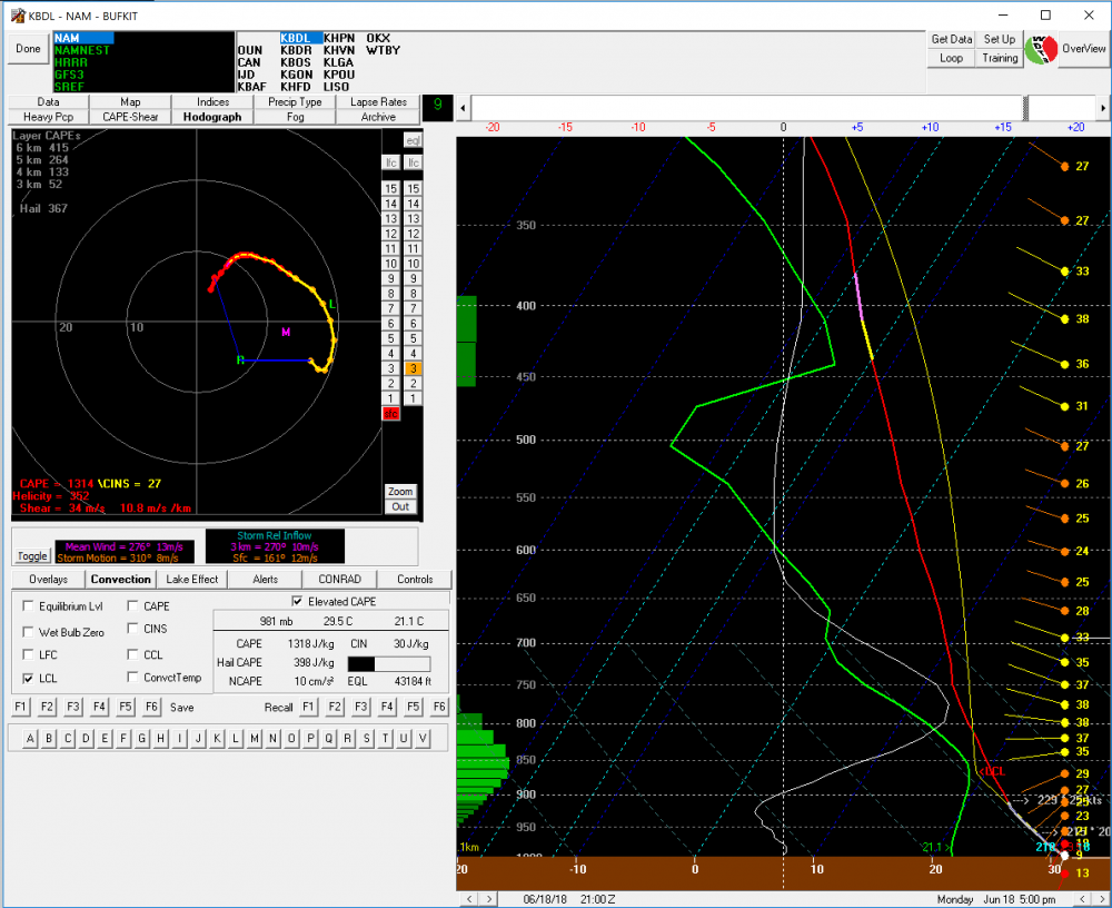
Here's a question I've always had but never found an answer. On bufkit in the hodograph section, on the bottom left of the hodograph there is an output for Cape and Helicity...does anyone know what level the Cape is measured in? is it surfaced-based (I'm guessing it is not sfc-based output) mixed-layer, or most-unstable? If i had to guess I would guess mixed-layer. I even tried playing with the llc values on the right to see if that would adjust Cape values but it only does so with helicity
-
1 minute ago, Typhoon Tip said:
actually for that matter... lake interface/trigger is nearing activation too with those lines of TCU along the eastern shores..
whoops...quoted wrong post but the convective temp is around 90 per forecast soundings
-
42 minutes ago, CT Rain said:
I've seen much worse setups...
This is certainly intriguing!
-
Wasn’t completely impressed with the 12z soundings from ALB and OKX but I was shocked to see that the H7-H5 lapse rates were 7...though they are weakening during the day. Shear isn’t terrible and still some directional shear in lowest few km.
There will be a few decent storms around the region today.
-
Some pretty impressive looking hodos tomorrow. Lapse rates and better forcing being a bit late hurt things but from C Ny into western SNE there will be some really good storms
-
Some decent looking holographs to watch too. If the plume of steeper lapse rates does time better tomorrow could be solid. Real shocked there isn’t a slight or even enhanced risk

General Severe Weather Discussion 2018
in New England
Posted
Could be quite interesting tomorrow night across NNE...NAM Nest has shown a decent looking squall line for a few runs.
This is WAY out there but next weekend could have some big potential if we can get things to time properly and get an EML advection.