

weatherwiz
-
Posts
76,468 -
Joined
-
Last visited
Content Type
Profiles
Blogs
Forums
American Weather
Media Demo
Store
Gallery
Posts posted by weatherwiz
-
-
Just now, RUNNAWAYICEBERG said:
Let’s not forget how dumb folks are thinking it’s rain when it’s zr so they drive like they normally do.
I love the famous "I have 4-wheel drive I'll be fine" line (it's ice not snow...unless your tires have custom made ice skates...good luck)
-
Just now, WxWatcher007 said:
Me too, but I think an upper end of 5” works here because pingers are never as far behind as one thinks down here. I’m hesitant to pull the trigger on a big icing forecast but I think it’s a legit mess.
I typically bump up the expected changeover by an hour or two from what models indicate. Yeah I'm not sure if this will be a big icing event...but we may straddle the line between issues and a bit more in the way of major issues (major issues being scattered power outages and some tree damage)
-
 1
1
-
-
Just now, RUNNAWAYICEBERG said:
The 4 northern counties as usual, agree. The ice is the bigger story.
With this...that makes the snowfall forecast just as important. If we get 3-4'' of snow followed by ice it will further enhance potential for some bigger issues.
-
1 minute ago, RUNNAWAYICEBERG said:
I could see a 4-6” swap across CCT before the ip/zr fest.
That's certainly in my mind...though I am going to place that closer to the border...mlvls always seem to warm rather quick. I am a little concerned b/c if we see ice accretion pushing .4'' that's sticking the head right into the start of some trouble territory.
-
I don't like how the NAM only has central/northern CT only in the upper 20's to around 30 for much of tomorrow.
Also props to @JGNYK03 for pointing out the discrepancy with my initial ice forecast map from Saturday...definitely going to be a much larger (and more uniform) even close down to the coast. Going to correct that with an update later this morning...along with adding a 4-6'' stripe along the CT/MA border.
-
 1
1
-
-
1 minute ago, RUNNAWAYICEBERG said:
13z hrrr already going colder so wait until go time to use it.
Looks like it will go sick with the thump....great sign
-
Has anyone had the chance to see how much longer after the model initiation start time does the HRRv4 actually initialize? 12z a no go yet on cod
-
there could be some nasty snow squalls Wednesday.
-
This deserve thread of the
yeardecade -
2 minutes ago, ORH_wxman said:
Guidance is showing the WAA sort of hit a brick wall in SNE earl tomorrow morning which is a good sign for some enhanced WCB precip....it almost starts getting shunted east a bit once it hits the wall.
I was getting a little nervous yesterday b/c it was looking like the core of the WAA was actually going to weaken prior to arriving into SNE...but the latest signals are a bit impressive. I am a bit nervous though down this way...there is some pretty strong lift overhead after the warmth aloft has moved through...we could have a period of some moderate-to-heavy ZR


-
1
-
-
2 minutes ago, ORH_wxman said:
Yeah this run showed maybe like 4-6" in about 6 hours. It's not a huge system, but it comes down pretty heavy for several hours at the peak.
It's a pretty good sign to see the front end lift here starting to emerge a bit more strongly on the models. You can actually see the isobars on the MSLP charts on the NAM really sort of tighten up and cluster closer together on the NAM...pretty good sign for heavier precip/lift
-
2 minutes ago, Typhoon Tip said:
Mm... but saying there's only 45 days of winter remaining on December 15 or 16 of any given year is so egregiously asinine it immediately molts all credibility of the person that makes the statement/sentiment. Personally, I don't care about the troll tactic - I don't actually take very much of who said what and why in here very seriously, and tend to ignore most of it because of it's intrinsically vapidity, and transparent cackling of the hoi polloi. However, it looks odd for you personally, Wiz', to defend that person - at all - when you're posts are nut-to-butt right up against one another. Just sayn' ... now you must know how defenders of Trump must feel. That sort of 'embarrassing timing' has been a regular folly of his Presidential tragic comedy.
I took the 45 days of winter (or however it was phrased) as more of a tongue-in-cheek comment than in actual seriousness. The bolded is pretty funny...and probably spot on

But trolling or whatever aside...the premise of the thoughts aren't very unreasonable. I don't have a problem with Dr. Dews or his posting style (everyone has their own) and not saying I endorsed anything...just that it isn't totally unreasonable given the uncertainties for the second half of this month.
-
1 minute ago, ORH_wxman said:
Thats a pretty damned big thump for the pike region through about 15z tomorrow.
Just over the border into MA...pretty good looking. Looks like some nice lift around the DGZ as well. Maybe 1.5''/Hr?

-
In all fairness Dr. Dews isn't completely off here. Obviously things can change moving into January and February (as we've seen in the past). Yes it isn't officially winter yet and yes we have been active in the storms department with many places above-average in snowfall...but we've also had our share of cutters and warm events. The signals moving through the remainder of the month and to at least start January are incredibly mixed and can go either way. The PAC is quite volatile and is going to remain that way for some time. As long as this is the case, all possibilities from one side of the spectrum to the other are always going to be at play. We've been lucky to cash in on the potential's we have had, however, that doesn't mean that will continue to be the theme.
As great as it is to have "favorable patterns" for snow/winter events...it doesn't always guarantee them. With our region we can easily have a great pattern and miss out...we can have an awful pattern but if the cards align perfectly we can cash in on that brief opportunity.
When you see models flip-flop like they have for the end of the month...that should be a huge flag and you can say all you want, analyze all you want, but until some sort of signal remains consistent...there is just no way of knowing which side will win.
-
2 minutes ago, STILL N OF PIKE said:
Wiz bc you understand soundings much more than I do
have you ever gone back and looked at soundings from say 10 warning level Events for HFD and say 10 advisory level events and looked at soundings. I imagine if you understand sounding this would be a valuable idea . I just say this bc you post them with all the forecasts (which I wished I cared More to understand them fully) but it seems like if I was studying met it might actually be something in the curriculum they already had you do to make someone understand not just system flags but also soundings limitations (positive “surprises”)..thou I don’t know if I’m right (as to how valuable that would be or not )
I've never done so for winter...but it's something I want to do. I really thought when I went back to school I could do a ton more with studying/research and the exact opposite happened...like I don't really think I have gained any additional (or very little) knowledge in winter wx or severe wx forecasting in the past 6-7 years.
I'm sure some of the better schools go into some depth/detail on what you mentioned in the bold but not where I went...overall the program is pretty bad. Outside of the equations and atmospheric physics/chemistry (which is tremendous to know and understand and can be a great value when applied to understanding forecast models) I learned absolutely ZERO about forecasting while in school...absolutely nothing. If I never found this board back in 2007 and just went to school I would have little to no knowledge of how to forecast...outside of rip and reading MOS and just looking at the basics on models.
In terms of forecast soundings we didn't do much with them...except look at a few examples from some random weather events in the 90's and just go over how to differentiate between Precip-types.
I honestly get really pissed when I think about things b/c of how little I learned over the past 6-7 years. Between school and working 2-3 jobs I had zero time to do much in my own time.
-
Just now, CoastalWx said:
But models do simulate convection. So while the process is real to a point, this isn't 1995 and guidance not handling convection properly. It would have to completely miss the mark on this.
so that's where the issues stemmed in the past? It had to do with poor handling/simulation of convection? Ok...that makes plenty of sense then. I just wasn't sure if there were other aspects involved.
-
One thing I've never truly understood is how convection plays a role in how precipitation evolves. From what I've always gathered if there is a ton of convection in the south that can rob moisture and end up screwing us? (Maybe they have a MetEd module on this process...or some papers). Anyways, is that possible here? It seems pretty ripe in the south for convection today. This 12z sounding at LCH is pretty amazing for mid-December. Should be right on the cusp of where convective initiation occurs.

-
On 12/13/2019 at 10:30 PM, OceanStWx said:
You know it must be a good December if we're talking about EMLs
")
Functionally I don't think there is any difference between the source region. What there has been some research into is the role aerosols play in worsening tornado outbreaks (hypothesis is that adding aerosols warms the lower levels, lowers LCLs, and increases wind shear). It's definitely an emerging area of research, but I think the Mexican aspect loops in because EMLs originating in that area tend of have more aerosols from Central American slash and burn operations.
Thanks for the reply!
I think it was after the May high risk issuance that didn't really pan out that I encountered some information on how EML origins from Mexico...couldn't remember what it was but the aerosols ring a bell. I will say...the hypothesis though is quite interesting. However, I think one of the bigger concerns in reading was smoke from wildfires. The aerosols aspect is very interesting though!
-
11 minutes ago, dendrite said:
That early H4-H5 lift usually winds up in virga.
I was trying to time that strongest lift with the arrival of the heavier precip...it did seem to somewhat match. But I do think we'll be dealing with some virga initially but if the intensities pan out hopefully it's brief.
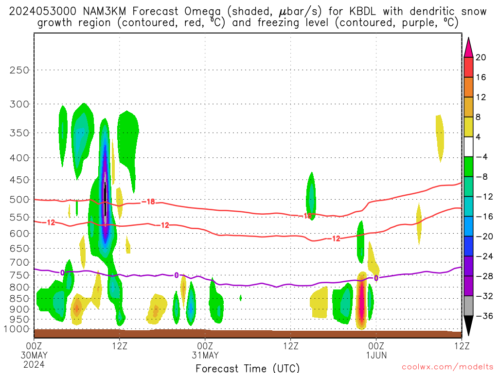
12 minutes ago, The 4 Seasons said:Coolwx is a great site to get a quick glance at omega/growth and p-type accumulation, if bufkit isn't your thing. Even so, it's still faster than downloading and loading profiles into bufkit.
6Z GFS has a lot of ice for CT ranging from .1-.6 and NAM from .1-.4 with the exception of BDL. Again southern CT inland from the immediate coast looks to be in the most trouble.
.666 Ice for OXC on the GFS

.thumb.png.18323c924d1dd88790d8598b2d1ce041.png)
Coolwx is certainly much more efficient then loading up bufkit profiles. A pretty underrated site as well for data.
The ice aspect is definitely a tad concerning...though I still think we will fall sort of a significant icing event but it will be bad enough to impact travel.
But in terms of the school cancellation stuff...tomorrow isn't really about snow...it's more the ice aspect. But I remember it being nearly impossible for West Hartford to cancel school growing up...every other surrounding school would be closed and we would be open or delayed. Snow totals had to be like 6-8"+ for us to have school cancelled...with the majority still falling during the early morning.
-
Just now, Snow88 said:
They cancel school for 4 inches ?
They cancel school for 2 flakes now.
-
 1
1
-
-
I certainly wonder if there can be like a 4-6'' spot up along the CT/MA border. Strongest lift here is just above the DGZ but the front end potential with this looks pretty intriguing.
-
1
-
-
The NAM never seems to handle these events well...outside of the CAD in the valleys but like Ray said it’s often too aggressive with mlvl warmth. Also seems to want to be too dry at the onset of things. After all the experience we have had with these in the boards...you almost don’t even need to look at models inside if like 24-48 hours to see how these event's will perform
I came home to...hardly any snow pack. When I left the morning I still had some inches but it’s virtually gone
-
2 minutes ago, dendrite said:
May randomly ban a few people if I don't get a few inches of snow to insulate my bamboo rhizomes before the neggies hit later this week.
Can’t ban me
-
1
-
-
6 minutes ago, JGNYK03 said:
Which is exactly why I think that line maybe be farther south. Going to be snow then mainly sleet and only some freezing rain north of 84 if the current colder trends continue.
Oh yeah...if the colder trends continue then absolutely. I would certainly adjust if that were the case. Right now though not 100% confident that happens (though I would hedge that way)


.png.0251878ea0b7892935720effe266f012.png)
12/17 Messy Mix
in New England
Posted
yeah the RGEM has me pretty damn concerned. that's a pretty decent signal across central CT.